
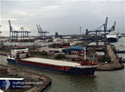
RONJA
General Cargo
Current Trip
| Time Travelled | 1 day |
|---|---|
| Remaining Time | 4 h, 10 mins |
| Distance Travelled | 312.37 nm |
| Remaining Distance | 39.55 nm |
| AVG Speed | 9.7 Knopen |
| MAX Speed | 12.3 Knopen |
| AVG Wind | 7.7 knots |
| MAX Wind | 14.8 knots |
| MIN Temp | 8.1°C / 46.58°F |
| MAX Temp | 14.6°C / 58.28°F |
| Diepgang | 5.7 M |
| Positie ontvangen | Nu |
Current Position
| Lengtegraad | -5.74667° |
|---|---|
| Breedtegraat | 49.91605° |
| Status | Under way using engine |
| Snelheid | 9.1 Knopen |
| Koers | 92.8° |
| Gebied | Celtic Sea |
| Station | T-AIS |
| Positie ontvangen | Nu |
Info
Information
The current position of RONJA is in Celtic Sea with coordinates 49.91605° / -5.74667° as reported on 2024-06-03 05:01 by AIS to our vessel tracker app. The vessel's current speed is 9.1 Knopen and is heading at the port of FALMOUTH. The estimated time of arrival as calculated by MyShipTracking vessel tracking app is 2024-06-03 09:11 LT
The vessel RONJA (IMO: 9434046, MMSI: 212569000) is a General Cargo that was built in 2008 ( 16 Jaar oud ). It's sailing under the flag of [CY] Cyprus.
In this page you can find informations about the vessels current position, last detected port calls, and current voyage information. If the vessels is not in coverage by AIS you will find the latest position.
The current position of RONJA is detected by our AIS receivers and we are not responsible for the reliability of the data. The last position was recorded while the vessel was in Coverage by the Ais receivers of our vessel tracking app.
The current draught of RONJA as reported by AIS is 5.7 meters
Weather
| Temperature | 14.5°C / 58.1°F |
|---|---|
| Wind Speed | 8 knots |
| Direction | 334° NNW |
| Pressure | 1025.2 hPa |
| Humidity | 81.9 % |
| Cloud Coverage | 82 % |
Featured Company
Last Port Calls
| Port | Arrival | Departure | Time In Port |
|---|---|---|---|
| 2024-05-31 18:56 | 2024-06-01 19:32 | 1 d | |
| 2024-05-31 01:11 | 2024-05-31 01:59 | 47 m | |
| 2024-05-31 00:28 | 2024-05-31 00:48 | 19 m | |
| 2024-05-29 18:38 | 2024-05-30 23:39 | 1 d | |
| 2024-05-29 17:28 | 2024-05-29 17:50 | 21 m | |
| 2024-05-29 16:29 | 2024-05-29 17:06 | 37 m | |
| 2024-05-27 07:55 | 2024-05-28 08:32 | 1 d | |
| 2024-05-24 10:38 | 2024-05-25 23:23 | 1 d | |
| 2024-05-23 18:21 | 2024-05-24 08:39 | 14 h | |
| 2024-05-21 22:20 | 2024-05-22 21:42 | 23 h |
Last Trips
| Origin | Departure | Destination | Arrival | Distance | |
|---|---|---|---|---|---|
| 2024-05-31 02:59 | 2024-05-31 19:56 | 148.72 nm | |||
| 2024-05-31 01:48 | 2024-05-31 02:11 | 1.67 nm | |||
| 2024-05-31 00:39 | 2024-05-31 01:28 | 4.72 nm | |||
| 2024-05-29 18:50 | 2024-05-29 19:38 | 5.01 nm | |||
| 2024-05-29 18:06 | 2024-05-29 18:28 | 1.90 nm | |||
| 2024-05-28 09:32 | 2024-05-29 17:29 | 278.11 nm | |||
| 2024-05-26 00:23 | 2024-05-27 08:55 | 270.96 nm | |||
| 2024-05-22 22:42 | 2024-05-24 11:38 | 161.37 nm | |||
| 2024-05-22 22:42 | 2024-05-23 19:21 | 137.58 nm | |||
| 2024-05-18 22:31 | 2024-05-21 23:20 | 625.17 nm |
Events
| Tijd | Evenement | Details | Positie / Bestemming | Info |
|---|---|---|---|---|
| 2024-06-03 02:14 | Status Changed | Under way using engine Default |
50.17639 / -5.99547
FALMOUTH
|
Snelheid: 8.4 kn Koers: 180° |
| 2024-06-03 02:04 | Status Changed | Default Under way using engine |
50.19946 / -5.99447
FALMOUTH
|
Snelheid: 8.2 kn Koers: 181° |
| 2024-06-02 23:14 | Status Changed | Under way using engine Default |
50.59091 / -5.98668
FALMOUTH
|
Snelheid: 8.7 kn Koers: 183° |
| 2024-06-02 23:12 | Status Changed | Default Under way using engine |
50.59536 / -5.98645
FALMOUTH
|
Snelheid: 8.7 kn Koers: 184.1° |
| 2024-06-02 22:31 | Status Changed | Under way using engine Default |
50.69791 / -5.98401
FALMOUTH
|
Snelheid: 9 kn Koers: 182° |
| 2024-06-02 22:28 | Status Changed | Default Under way using engine |
50.70459 / -5.98396
FALMOUTH
|
Snelheid: 9 kn Koers: 181.3° |
| 2024-06-02 21:04 | Status Changed | Under way using engine Default |
50.92040 / -5.98501
FALMOUTH
|
Snelheid: 9.4 kn Koers: 180° |
| 2024-06-02 20:04 | Status Changed | Default Under way using engine |
51.07626 / -5.98281
FALMOUTH
|
Snelheid: 9.3 kn Koers: 180° |
| 2024-06-02 20:04 | Status Changed | Under way using engine Default |
51.07759 / -5.98279
FALMOUTH
|
Snelheid: 9.4 kn Koers: 181° |
| 2024-06-02 20:00 | Binnenbereik |
51.07720 / -5.98280
Celtic Sea
FALMOUTH
|
Snelheid: 9.3 kn Koers: 180° |