
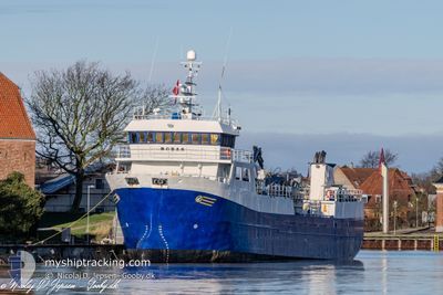
ROBAS
Fish Carrier
Current Trip
INFO CH 16
| Time Travelled | 2 days |
|---|---|
| Remaining Time | --- |
| Distance Travelled | 320.75 nm |
| Remaining Distance | --- |
| AVG Speed | 8 Knopen |
| MAX Speed | 11.7 Knopen |
| AVG Wind | 10.6 knots |
| MAX Wind | 18.8 knots |
| MIN Temp | 8.9°C / 48.02°F |
| MAX Temp | 21°C / 69.8°F |
| Diepgang | 5.3 M |
| Positie ontvangen | 11 m geleden |
Current Position
| Lengtegraad | 12.67115° |
|---|---|
| Breedtegraat | 66.54751° |
| Status | Under way using engine |
| Snelheid | 8.7 Knopen |
| Koers | 221.2° |
| Gebied | Norwegian Sea |
| Station | T-AIS |
| Positie ontvangen | 11 m geleden |
Info
Information
The current position of ROBAS is in Norwegian Sea with coordinates 66.54751° / 12.67115° as reported on 2024-09-01 05:08 by AIS to our vessel tracker app. The vessel's current speed is 8.7 Knopen
The vessel ROBAS (IMO: 9165487, MMSI: 259488000) is a Fish Carrier that was built in 1998 ( 26 Jaar oud ). It's sailing under the flag of [NO] Norway.
In this page you can find informations about the vessels current position, last detected port calls, and current voyage information. If the vessels is not in coverage by AIS you will find the latest position.
The current position of ROBAS is detected by our AIS receivers and we are not responsible for the reliability of the data. The last position was recorded while the vessel was in Coverage by the Ais receivers of our vessel tracking app.
The current draught of ROBAS as reported by AIS is 5.3 meters
Weather
| Temperature | 12.5°C / 54.5°F |
|---|---|
| Wind Speed | 5 knots |
| Direction | 235° SW |
| Pressure | 1028.4 hPa |
| Humidity | 81.4 % |
| Cloud Coverage | 54 % |
Featured Company
Last Port Calls
| Port | Arrival | Departure | Time In Port |
|---|---|---|---|
| 2024-08-29 11:40 | 2024-08-29 13:19 | 1 h | |
| 2024-08-25 16:33 | 2024-08-25 19:15 | 2 h | |
| 2024-08-22 19:38 | 2024-08-23 01:05 | 5 h | |
| 2024-08-21 09:25 | 2024-08-21 12:24 | 2 h | |
| 2024-08-15 19:30 | 2024-08-15 23:11 | 3 h | |
| 2024-08-11 18:37 | 2024-08-11 20:41 | 2 h | |
| 2024-08-06 03:26 | 2024-08-07 23:58 | 1 d | |
| 2024-07-29 19:59 | 2024-07-31 17:06 | 1 d | |
| 2024-07-25 01:42 | 2024-07-25 01:50 | 8 m | |
| 2024-07-21 20:07 | 2024-07-22 06:36 | 10 h |
Last Trips
| Origin | Departure | Destination | Arrival | Distance | |
|---|---|---|---|---|---|
| 2024-08-25 19:15 | 2024-08-29 11:40 | 380.33 nm | |||
| 2024-08-23 01:05 | 2024-08-25 16:33 | 268.72 nm | |||
| 2024-08-21 12:24 | 2024-08-22 19:38 | 287.42 nm | |||
| 2024-08-15 23:11 | 2024-08-21 09:25 | 828.73 nm | |||
| 2024-08-11 20:41 | 2024-08-15 19:30 | 437.84 nm | |||
| 2024-08-07 23:58 | 2024-08-11 18:37 | 550.72 nm | |||
| 2024-07-31 17:06 | 2024-08-06 03:26 | 1059.84 nm | |||
| 2024-07-25 01:50 | 2024-07-29 19:59 | 224.85 nm | |||
| 2024-07-22 06:36 | 2024-07-25 01:42 | 452.47 nm | |||
| 2024-07-18 17:33 | 2024-07-21 20:07 | 444.20 nm |
Events
| Tijd | Evenement | Details | Positie / Bestemming | Info |
|---|---|---|---|---|
| 2024-09-01 02:28 | ETA Changed | 2024/09/01 09:00 2025/08/31 23:00 |
66.67569 / 13.42169
INFO CH 16
|
Snelheid: 8.9 kn Koers: 287.2° |
| 2024-09-01 02:21 | Draught Changed | 5.3 3.3 |
66.67127 / 13.45970
INFO CH 16
|
Snelheid: 8.9 kn Koers: 285° |
| 2024-09-01 02:01 | Start beweging | 6.61 nm, East of JEKTVIK |
66.65010 / 13.55283
INFO CH 16
|
Snelheid: 5.7 kn Koers: 314.1° |
| 2024-09-01 00:08 | ETA Changed | 2025/08/31 23:00 2024/08/31 23:00 |
66.64825 / 13.56283
INFO CH 16
|
Snelheid: Koers: 100° |
| 2024-08-31 22:03 | Stop beweging | 6.82 nm, East of JEKTVIK |
66.64839 / 13.56288
INFO CH 16
|
Snelheid: 0.1 kn Koers: 96° |
| 2024-08-31 13:44 | Draught Changed | 3.3 5.3 |
65.91531 / 12.38037
INFO CH 16
|
Snelheid: 11.2 kn Koers: 30.6° |
| 2024-08-31 11:54 | ETA Changed | 2024/08/31 23:00 2024/08/31 07:00 |
65.64517 / 12.25769
INFO CH 16
|
Snelheid: 8.7 kn Koers: 10.1° |
| 2024-08-31 06:16 | Start beweging | 8.23 nm, North of ROERVIK |
64.98838 / 11.13404
INFO CH 16
|
Snelheid: 7.9 kn Koers: 46.8° |
| 2024-08-31 05:00 | Stop beweging | 8.07 nm, North of ROERVIK |
64.98556 / 11.13392
INFO CH 16
|
Snelheid: Koers: 1° |
| 2024-08-31 04:51 | Start beweging | 8.22 nm, North of ROERVIK |
64.98735 / 11.12823
INFO CH 16
|
Snelheid: 4.1 kn Koers: 163° |