
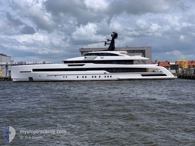
RIO
Pleasure Craft
Current Trip
| Time Travelled | 13 h, 17 mins |
|---|---|
| Remaining Time | --- |
| Distance Travelled | 82.11 nm |
| Remaining Distance | --- |
| AVG Speed | 12.3 Knopen |
| MAX Speed | 12.8 Knopen |
| AVG Wind | 8.5 knots |
| MAX Wind | 14 knots |
| MIN Temp | 20.8°C / 69.44°F |
| MAX Temp | 21.3°C / 70.34°F |
| Diepgang | 3.2 M |
| Positie ontvangen | 6 h, 37 m geleden |
Current Position
| Lengtegraad | --- |
|---|---|
| Breedtegraat | --- |
| Status | Under way using engine |
| Snelheid | 12.6 Knopen |
| Koers | 239.9° |
| Gebied | North Atlantic Ocean |
| Station | T-AIS |
| Positie ontvangen | 6 h, 37 m geleden |
Info
Information
The current position of RIO is in North Atlantic Ocean with coordinates 27.52086° / -17.26462° as reported on 2025-12-09 18:18 by AIS to our vessel tracker app. The vessel's current speed is 12.6 Knopen and is heading at the port of PHILIPSBURG. The estimated time of arrival as calculated by MyShipTracking vessel tracking app is 2025-12-18 08:00 LT
The vessel RIO (IMO: 9851024, MMSI: 229830000) is a Pleasure Craft It's sailing under the flag of [MT] Malta.
In this page you can find informations about the vessels current position, last detected port calls, and current voyage information. If the vessels is not in coverage by AIS you will find the latest position.
The current position of RIO is detected by our AIS receivers and we are not responsible for the reliability of the data. The last position was recorded while the vessel was in Coverage by the Ais receivers of our vessel tracking app.
The current draught of RIO as reported by AIS is 3.2 meters
Weather
| Temperature | 21.2°C / 70.16°F |
|---|---|
| Wind Speed | 7 knots |
| Direction | 314° NW |
| Pressure | 1022.3 hPa |
| Humidity | 59.4 % |
| Cloud Coverage | 38 % |
Featured Company
Most Visited Ports (Last year)
| Port | Arrivals | |
|---|---|---|
| 7 | ||
| 2 | ||
| 2 | ||
| 1 | ||
| 1 | ||
| 1 |
Events
| Tijd | Evenement | Details | Positie / Bestemming | Info |
|---|---|---|---|---|
| 2025-12-09 18:18 | Buitenbereik |
27.52086 / -17.26462
North Atlantic Ocean
SINT MAARTEN
|
Snelheid: 12.6 kn Koers: 239.9° |
|
| 2025-12-09 17:34 | Binnenbereik |
27.59478 / -17.11999
North Atlantic Ocean
SINT MAARTEN
|
Snelheid: 12.3 kn Koers: 239.3° |
|
| 2025-12-09 16:23 | Buitenbereik |
27.72042 / -16.87489
North Atlantic Ocean
SINT MAARTEN
|
Snelheid: 12.6 kn Koers: 240.4° |
|
| 2025-12-09 12:09 | Destination Changed | SINT MAARTEN TENERIFE |
28.35656 / -16.27122
SINT MAARTEN
|
Snelheid: 12.2 kn Koers: 198.7° |
| 2025-12-09 12:02 | ETA Changed | 2025/12/18 12:00 2025/12/08 03:00 |
28.37794 / -16.26283
TENERIFE
|
Snelheid: 12.3 kn Koers: 199.1° |
| 2025-12-09 12:02 | Status Changed | Under way using engine Moored |
28.38003 / -16.26201
TENERIFE
|
Snelheid: 12.3 kn Koers: 199.5° |
| 2025-12-09 11:38 | Vertrekhaven |
|
28.45184 / -16.24676
TENERIFE
|
Snelheid: 7.6 kn Koers: 174° |
| 2025-12-09 11:33 | Start beweging |
28.46055 / -16.24592
[ES] TENERIFE
|
Snelheid: 5.5 kn Koers: 212° |
|
| 2025-12-08 02:38 | Destination Changed | TENERIFE SINT MAARTEN |
28.46220 / -16.24438
[ES] TENERIFE
|
Snelheid: Koers: 205° |
| 2025-12-08 02:38 | ETA Changed | 2025/12/08 03:00 2025/12/16 10:00 |
28.46220 / -16.24438
[ES] TENERIFE
|
Snelheid: Koers: 205° |