
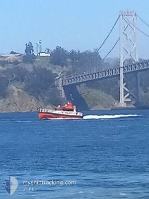
PV GOLDEN GATE
Pilot Vessel
Current Trip
| Trip Time | 2 h, 18 mins |
|---|---|
| Trip Distance | 28.79 nm |
| AVG Speed | 17.1 Knopen |
| MAX Speed | 17.1 Knopen |
| Diepgang | 0 M |
| AVG Wind | 3.7 knots |
| MAX Wind | 6 knots |
| MIN Temp | 8.4°C / 47.12°F |
| MAX Temp | 10.7°C / 51.26°F |
| Positie ontvangen | 1 m geleden |
Current Position
| Lengtegraad | --- |
|---|---|
| Breedtegraat | --- |
| Status | Under way using engine |
| Snelheid | 0.1 Knopen |
| Koers | 182° |
| Gebied | North Pacific Ocean |
| Station | T-AIS |
| Positie ontvangen | 1 m geleden |
Info
Information
The current position of PV GOLDEN GATE is in North Pacific Ocean with coordinates 37.81036° / -122.32446° as reported on 2025-12-05 15:40 by AIS to our vessel tracker app. The vessel's current speed is 0.1 Knopen and is currently inside the port of OAKLAND.
The vessel PV GOLDEN GATE (MMSI: 368302170) is a Pilot Vessel It's sailing under the flag of [US] USA.
In this page you can find informations about the vessels current position, last detected port calls, and current voyage information. If the vessels is not in coverage by AIS you will find the latest position.
The current position of PV GOLDEN GATE is detected by our AIS receivers and we are not responsible for the reliability of the data. The last position was recorded while the vessel was in Coverage by the Ais receivers of our vessel tracking app.
Weather
| Temperature | 8.4°C / 47.12°F |
|---|---|
| Wind Speed | 3 knots |
| Direction | 50° NE |
| Pressure | 1022.1 hPa |
| Humidity | 53.5 % |
| Cloud Coverage | --- |
Featured Company
Last Port Calls
| Port | Arrival | Departure | Time In Port |
|---|---|---|---|
| 2025-12-05 07:38 | |||
| 2025-12-05 05:17 | 2025-12-05 05:20 | 3 m | |
| 2025-12-05 02:33 | 2025-12-05 03:18 | 44 m | |
| 2025-12-04 23:26 | 2025-12-05 01:43 | 2 h | |
| 2025-12-04 23:10 | 2025-12-04 23:15 | 5 m | |
| 2025-12-04 20:52 | 2025-12-04 22:21 | 1 h | |
| 2025-12-04 16:27 | 2025-12-04 20:27 | 3 h | |
| 2025-12-04 16:06 | 2025-12-04 16:19 | 12 m | |
| 2025-12-04 15:30 | 2025-12-04 15:36 | 6 m | |
| 2025-12-04 14:18 | 2025-12-04 14:47 | 28 m |
Most Visited Ports (Last year)
| Port | Arrivals | |
|---|---|---|
| 2728 | ||
| 1954 | ||
| 27 |
Last Trips
| Origin | Departure | Destination | Arrival | Distance | |
|---|---|---|---|---|---|
| 2025-12-05 05:20 | 2025-12-05 07:38 | 28.79 nm | |||
| 2025-12-05 03:18 | 2025-12-05 05:17 | 43.42 nm | |||
| 2025-12-05 01:43 | 2025-12-05 02:33 | 12.03 nm | |||
| 2025-12-04 23:15 | 2025-12-04 23:26 | 2.55 nm | |||
| 2025-12-04 22:21 | 2025-12-04 23:10 | 13.20 nm | |||
| 2025-12-04 20:27 | 2025-12-04 20:52 | 8.22 nm | |||
| 2025-12-04 16:19 | 2025-12-04 16:27 | 2.70 nm | |||
| 2025-12-04 15:36 | 2025-12-04 16:06 | 8.75 nm | |||
| 2025-12-04 14:47 | 2025-12-04 15:30 | 11.18 nm | |||
| 2025-12-04 13:52 | 2025-12-04 14:18 | 8.44 nm |
Events
| Tijd | Evenement | Details | Positie / Bestemming | Info |
|---|---|---|---|---|
| 2025-12-05 15:38 | Stop beweging |
37.81037 / -122.32450
[US] OAKLAND
|
Snelheid: 0.1 kn Koers: 171° |
|
| 2025-12-05 15:38 | Aankomsthaven |
|
37.81037 / -122.32450
[US] OAKLAND
|
Snelheid: 0.6 kn Koers: 168° |
| 2025-12-05 15:28 | Start beweging | 2.04 nm, East of SAN FRANCISCO |
37.76762 / -122.33837
SEA
|
Snelheid: 20 kn Koers: 349.3° |
| 2025-12-05 15:27 | Stop beweging | 2.06 nm, East of SAN FRANCISCO |
37.76573 / -122.33801
SEA
|
Snelheid: 0.3 kn Koers: 329° |
| 2025-12-05 15:16 | Start beweging | 4.25 nm, South East of SAN FRANCISCO |
37.71767 / -122.31946
SEA
|
Snelheid: 11.9 kn Koers: 16.9° |
| 2025-12-05 15:03 | Stop beweging | 4.3 nm, South East of SAN FRANCISCO |
37.71581 / -122.32067
SEA
|
Snelheid: 0.3 kn Koers: 340° |
| 2025-12-05 14:21 | Start beweging | 2.58 nm, West of TREASURE ISLAND |
37.81019 / -122.41956
SEA
|
Snelheid: 4.1 kn Koers: 300° |
| 2025-12-05 14:00 | Stop beweging | 2.5 nm, West of TREASURE ISLAND |
37.80921 / -122.41757
SEA
|
Snelheid: 0.3 kn Koers: 313° |
| 2025-12-05 13:37 | Start beweging | 3.29 nm, South East of SAN FRANCISCO |
37.72245 / -122.34475
SEA
|
Snelheid: 24.4 kn Koers: 340.5° |
| 2025-12-05 13:35 | Stop beweging | 3.4 nm, South East of SAN FRANCISCO |
37.72119 / -122.34283
SEA
|
Snelheid: 0.2 kn Koers: 147° |