
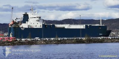
MINCHAH
Vehicles Carrier
Current Trip
| Trip Time | 2 days |
|---|---|
| Trip Distance | 975.54 nm |
| AVG Speed | 16.9 Knopen |
| MAX Speed | 19 Knopen |
| Diepgang | 5 M |
| AVG Wind | 11.9 knots |
| MAX Wind | 22 knots |
| MIN Temp | 22.5°C / 72.5°F |
| MAX Temp | 28.2°C / 82.76°F |
| Positie ontvangen | 1 d geleden |
Current Position
| Lengtegraad | -74.63350° |
|---|---|
| Breedtegraat | 20.83833° |
| Status | Under way using engine |
| Snelheid | 17.4 Knopen |
| Koers | 299° |
| Gebied | North Atlantic Ocean |
| Station | T-AIS |
| Positie ontvangen | 1 d geleden |
Info
Information
The current position of MINCHAH is in North Atlantic Ocean with coordinates 20.83833° / -74.63350° as reported on 2024-04-24 13:29 by AIS to our vessel tracker app. The vessel's current speed is 17.4 Knopen and is currently inside the port of MARIEL.
The vessel MINCHAH (IMO: 9131955, MMSI: 352001233) is a Vehicles Carrier that was built in 1997 ( 27 Jaar oud ). It's sailing under the flag of [PA] Panama.
In this page you can find informations about the vessels current position, last detected port calls, and current voyage information. If the vessels is not in coverage by AIS you will find the latest position.
The current position of MINCHAH is detected by our AIS receivers and we are not responsible for the reliability of the data. The last position was recorded while the vessel was in Coverage by the Ais receivers of our vessel tracking app.
The current draught of MINCHAH as reported by AIS is 5 meters
Weather
| Temperature | 26°C / 78.8°F |
|---|---|
| Wind Speed | 18 knots |
| Direction | 48° NE |
| Pressure | 1015.2 hPa |
| Humidity | 58 % |
| Cloud Coverage | --- |
Featured Company
Last Port Calls
| Port | Arrival | Departure | Time In Port |
|---|---|---|---|
| 2024-04-25 21:16 | |||
| 2024-04-21 12:07 | 2024-04-23 09:14 | 1 d | |
| 2024-04-17 15:13 | 2024-04-18 07:35 | 16 h | |
| 2024-04-17 14:45 | 2024-04-17 14:54 | 9 m | |
| 2024-04-15 10:55 | 2024-04-15 22:25 | 11 h | |
| 2024-04-08 11:14 | 2024-04-09 08:24 | 21 h | |
| 2024-04-03 00:51 | 2024-04-03 20:40 | 19 h | |
| 2024-03-30 07:41 | 2024-03-30 22:54 | 15 h | |
| 2024-03-30 07:16 | 2024-03-30 07:22 | 6 m | |
| 2024-03-26 01:13 | 2024-03-26 20:07 | 18 h |
Most Visited Ports (Last year)
| Port | Arrivals | |
|---|---|---|
| 24 | ||
| 21 | ||
| 20 | ||
| 7 | ||
| 6 | ||
| 4 |
Last Trips
| Origin | Departure | Destination | Arrival | Distance | |
|---|---|---|---|---|---|
| 2024-04-23 05:14 | 2024-04-25 17:16 | 975.54 nm | |||
| 2024-04-18 03:35 | 2024-04-21 08:07 | 949.11 nm | |||
| 2024-04-17 10:54 | 2024-04-17 11:13 | 0.75 nm | |||
| 2024-04-15 18:25 | 2024-04-17 10:45 | 647.41 nm | |||
| 2024-04-09 04:24 | 2024-04-15 06:55 | 1394.03 nm | |||
| 2024-04-03 16:40 | 2024-04-08 07:14 | 1498.95 nm | |||
| 2024-03-30 18:54 | 2024-04-02 20:51 | 951.09 nm | |||
| 2024-03-30 03:22 | 2024-03-30 03:41 | 0.83 nm | |||
| 2024-03-26 16:07 | 2024-03-30 03:16 | 959.38 nm | |||
| 2024-03-25 01:24 | 2024-03-25 21:13 | 233.58 nm |
Events
| Tijd | Evenement | Details | Positie / Bestemming | Info |
|---|---|---|---|---|
| 2024-04-25 22:23 | Stop beweging |
23.00703 / -82.76042
[CU] MARIEL
|
Snelheid: Koers: 150° |
|
| 2024-04-25 21:16 | Aankomsthaven |
|
23.02167 / -82.75833
[CU] MARIEL
|
Snelheid: 11 kn Koers: 179° |
| 2024-04-24 13:37 | Status Changed | Default Under way using engine |
20.86167 / -74.67667
CU MAR
|
Snelheid: 17.4 kn Koers: 299° |
| 2024-04-24 13:29 | Status Changed | Under way using engine Default |
20.83833 / -74.63350
CU MAR
|
Snelheid: 17 kn Koers: 299° |
| 2024-04-24 13:29 | Buitenbereik |
20.83833 / -74.63350
North Atlantic Ocean
CU MAR
|
Snelheid: 17.4 kn Koers: 299° |
|
| 2024-04-24 12:58 | Status Changed | Default Under way using engine |
20.76833 / -74.50166
CU MAR
|
Snelheid: 17 kn Koers: 299° |
| 2024-04-24 12:48 | Status Changed | Under way using engine Default |
20.74400 / -74.45267
CU MAR
|
Snelheid: 17 kn Koers: 300° |
| 2024-04-24 12:01 | Status Changed | Default Under way using engine |
20.63167 / -74.24667
CU MAR
|
Snelheid: 17.5 kn Koers: 299° |
| 2024-04-24 08:53 | Gevonden in zee | Cuban part of the North Atlantic Ocean |
19.92817 / -73.99700
North Atlantic Ocean
CU MAR
|
Snelheid: 16.1 kn Koers: 20° |
| 2024-04-24 07:49 | Wijzig zee gebeid | Cuban part of the Caribbean Sea Domican Republic part of the Caribbean Sea |
19.65550 / -74.10384
Caribbean Sea
CU MAR
|
Snelheid: 16.3 kn Koers: 20° |