
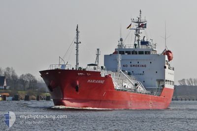
MARIANNE
Lpg Tanker
Current Trip
| Time Travelled | 16 h, 41 mins |
|---|---|
| Remaining Time | --- |
| Distance Travelled | 188.54 nm |
| Remaining Distance | --- |
| AVG Speed | 11.9 Knopen |
| MAX Speed | 12.6 Knopen |
| AVG Wind | 11.2 knots |
| MAX Wind | 16 knots |
| MIN Temp | 13.8°C / 56.84°F |
| MAX Temp | 14.7°C / 58.46°F |
| Diepgang | 5.9 M |
| Positie ontvangen | 38 m geleden |
Current Position
| Lengtegraad | -9.95543° |
|---|---|
| Breedtegraat | 40.67941° |
| Status | Under way using engine |
| Snelheid | 12.3 Knopen |
| Koers | 358.8° |
| Gebied | North Atlantic Ocean |
| Station | T-AIS |
| Positie ontvangen | 38 m geleden |
Info
Information
The current position of MARIANNE is in North Atlantic Ocean with coordinates 40.67941° / -9.95543° as reported on 2024-05-02 19:47 by AIS to our vessel tracker app. The vessel's current speed is 12.3 Knopen
The vessel MARIANNE (IMO: 9474539, MMSI: 205769000) is a Lpg Tanker that was built in 2009 ( 15 Jaar oud ). It's sailing under the flag of [BE] Belgium.
In this page you can find informations about the vessels current position, last detected port calls, and current voyage information. If the vessels is not in coverage by AIS you will find the latest position.
The current position of MARIANNE is detected by our AIS receivers and we are not responsible for the reliability of the data. The last position was recorded while the vessel was in Coverage by the Ais receivers of our vessel tracking app.
The current draught of MARIANNE as reported by AIS is 5.9 meters
Weather
| Temperature | 14.5°C / 58.1°F |
|---|---|
| Wind Speed | 16 knots |
| Direction | 260° W |
| Pressure | 1018.6 hPa |
| Humidity | 63.6 % |
| Cloud Coverage | 1 % |
Featured Company
Last Port Calls
| Port | Arrival | Departure | Time In Port |
|---|---|---|---|
| 2024-05-01 06:43 | 2024-05-02 03:44 | 21 h | |
| 2024-04-28 20:44 | 2024-04-30 08:08 | 1 d | |
| 2024-04-23 04:24 | 2024-04-23 22:36 | 18 h | |
| 2024-04-17 20:37 | 2024-04-19 07:39 | 1 d | |
| 2024-04-14 23:15 | 2024-04-16 14:34 | 1 d | |
| 2024-04-13 08:39 | 2024-04-14 20:57 | 1 d | |
| 2024-04-08 07:27 | 2024-04-09 07:41 | 1 d | |
| 2024-03-27 23:23 | 2024-04-01 08:16 | 4 d | |
| 2024-03-20 11:23 | 2024-03-21 20:54 | 1 d | |
| 2024-03-16 14:08 | 2024-03-17 11:19 | 21 h |
Last Trips
| Origin | Departure | Destination | Arrival | Distance | |
|---|---|---|---|---|---|
| 2024-04-30 09:08 | 2024-05-01 07:43 | 255.27 nm | |||
| 2024-04-24 00:36 | 2024-04-28 21:44 | 393.41 nm | |||
| 2024-04-19 09:39 | 2024-04-23 06:24 | 1017.19 nm | |||
| 2024-04-16 16:34 | 2024-04-17 22:37 | 334.08 nm | |||
| 2024-04-14 22:57 | 2024-04-15 01:15 | 31.57 nm | |||
| 2024-04-09 08:41 | 2024-04-13 10:39 | 1155.56 nm | |||
| 2024-04-01 10:16 | 2024-04-08 08:27 | 1236.16 nm | |||
| 2024-03-21 21:54 | 2024-03-28 00:23 | 130.92 nm | |||
| 2024-03-17 12:19 | 2024-03-20 12:23 | 652.98 nm | |||
| 2024-03-14 13:49 | 2024-03-16 15:08 | 620.36 nm |
Events
| Tijd | Evenement | Details | Positie / Bestemming | Info |
|---|---|---|---|---|
| 2024-05-02 19:47 | Status Changed | Under way using engine Default |
40.67941 / -9.95543
PTSIE>NLRTM
|
Snelheid: 11.9 kn Koers: 359° |
| 2024-05-02 19:47 | Binnenbereik |
40.67941 / -9.95543
North Atlantic Ocean
PTSIE>NLRTM
|
Snelheid: 12.3 kn Koers: 358.8° |
|
| 2024-05-02 14:30 | Status Changed | Default Under way using engine |
39.66344 / -9.95955
PTSIE>NLRTM
|
Snelheid: 12.5 kn Koers: 359.1° |
| 2024-05-02 14:22 | Buitenbereik |
39.63626 / -9.95869
North Atlantic Ocean
PTSIE>NLRTM
|
Snelheid: 12.5 kn Koers: 359.1° |
|
| 2024-05-02 04:13 | Draught Changed | 5.9 5.8 |
37.97753 / -8.95028
PTSIE>NLRTM
|
Snelheid: 11.5 kn Koers: 318.9° |
| 2024-05-02 03:49 | Draught Changed | 5.8 4.9 |
37.92616 / -8.89086
PTSIE>NLRTM
|
Snelheid: 9.4 kn Koers: 260.6° |
| 2024-05-02 03:49 | Destination Changed | PTSIE>NLRTM PTLEI>PTSIE |
37.92616 / -8.89086
PTSIE>NLRTM
|
Snelheid: 9.4 kn Koers: 260.6° |
| 2024-05-02 03:49 | ETA Changed | 2024/05/05 22:00 2024/05/01 04:00 |
37.92616 / -8.89086
PTSIE>NLRTM
|
Snelheid: 9.4 kn Koers: 260.6° |
| 2024-05-02 03:44 | Vertrekhaven |
|
37.93423 / -8.88443
PTLEI>PTSIE
|
Snelheid: 7.4 kn Koers: 181° |
| 2024-05-02 03:37 | Start beweging |
37.94720 / -8.88538
[PT] SINES
|
Snelheid: 4.3 kn Koers: 177° |