
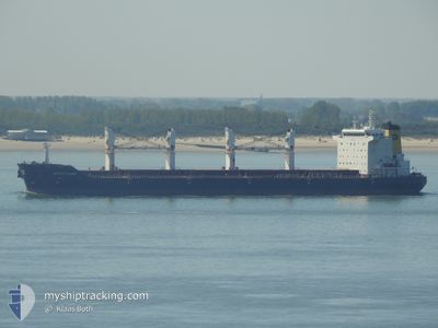
KSL RUNYANG
Bulk Carrier
Current Trip
| Trip Time | 1 day |
|---|---|
| Trip Distance | 142.43 nm |
| AVG Speed | 9.9 Knopen |
| MAX Speed | 12.3 Knopen |
| Diepgang | 10.4 M |
| AVG Wind | 9.8 knots |
| MAX Wind | 16.3 knots |
| MIN Temp | 14.9°C / 58.82°F |
| MAX Temp | 21.4°C / 70.52°F |
| Positie ontvangen | 18 h, 13 m geleden |
Current Position
| Lengtegraad | --- |
|---|---|
| Breedtegraat | --- |
| Status | Under way using engine |
| Snelheid | 5.9 Knopen |
| Koers | 296.6° |
| Gebied | Persian Gulf |
| Station | T-AIS |
| Positie ontvangen | 18 h, 13 m geleden |
Info
Information
The current position of KSL RUNYANG is in Persian Gulf with coordinates 30.00157° / 47.96980° as reported on 2025-12-12 01:38 by AIS to our vessel tracker app. The vessel's current speed is 5.9 Knopen and is currently inside the port of UMM QASR.
The vessel KSL RUNYANG (IMO: 9331696, MMSI: 538003716) is a Bulk Carrier that was built in 2009 ( 16 Jaar oud ). It's sailing under the flag of [MH] Marshall Is.
In this page you can find informations about the vessels current position, last detected port calls, and current voyage information. If the vessels is not in coverage by AIS you will find the latest position.
The current position of KSL RUNYANG is detected by our AIS receivers and we are not responsible for the reliability of the data. The last position was recorded while the vessel was in Coverage by the Ais receivers of our vessel tracking app.
The current draught of KSL RUNYANG as reported by AIS is 10.4 meters
Weather
| Temperature | 18.6°C / 65.48°F |
|---|---|
| Wind Speed | 4 knots |
| Direction | 74° ENE |
| Pressure | 1016.1 hPa |
| Humidity | 40.1 % |
| Cloud Coverage | 25 % |
Featured Company
Most Visited Ports (Last year)
| Port | Arrivals | |
|---|---|---|
| 1 | ||
| 1 | ||
| 1 | ||
| 1 | ||
| 1 | ||
| 1 |
Events
| Tijd | Evenement | Details | Positie / Bestemming | Info |
|---|---|---|---|---|
| 2025-12-12 11:07 | Stop beweging |
30.05878 / 47.92845
[IQ] UMM QASR
|
Snelheid: Koers: 139° |
|
| 2025-12-12 10:05 | Aankomsthaven |
|
30.03706 / 47.95215
[IQ] UMM QASR
|
Snelheid: 4.9 kn Koers: 331° |
| 2025-12-12 10:01 | Start beweging | 0.2 nm, South East of UMM QASR |
30.03120 / 47.95577
UMM_QASR;:_
|
Snelheid: 4.9 kn Koers: 331° |
| 2025-12-12 02:05 | Stop beweging | 0.36 nm, South of UMM QASR |
30.02791 / 47.95562
UMM_QASR;:_
|
Snelheid: 0.3 kn Koers: 13° |
| 2025-12-12 01:45 | Status Changed | Default Under way using engine |
30.00874 / 47.96096
UMM_QASR;:_
|
Snelheid: 5.9 kn Koers: 296.6° |
| 2025-12-12 01:38 | Buitenbereik |
30.00157 / 47.96980
Persian Gulf
UMM_QASR;:_
|
Snelheid: 5.9 kn Koers: 296.6° |
|
| 2025-12-12 01:23 | Wijzig zee gebeid | Iraqi part of the Persian Gulf Kuwaiti part of the Persian Gulf |
29.99439 / 48.00820
Persian Gulf
UMM_QASR;:_
|
Snelheid: 10 kn Koers: 272.4° |
| 2025-12-12 01:14 | Wijzig zee gebeid | Kuwaiti part of the Persian Gulf Iraqi part of the Persian Gulf |
30.00862 / 48.03252
Persian Gulf
UMM_QASR;:_
|
Snelheid: 11 kn Koers: 222° |
| 2025-12-12 01:08 | Status Changed | Under way using engine Default |
30.02068 / 48.04556
UMM_QASR;:_
|
Snelheid: 12.2 kn Koers: 247° |
| 2025-12-12 01:01 | Status Changed | Default Under way using engine |
30.03126 / 48.07121
UMM_QASR;:_
|
Snelheid: 12.1 kn Koers: 273° |