
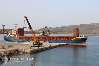
KARIBOU
General Cargo
Current Trip
| Trip Time | 13 h, 1 mins |
|---|---|
| Trip Distance | 124.09 nm |
| AVG Speed | 9.5 Knopen |
| MAX Speed | 10.2 Knopen |
| Diepgang | 3.4 M |
| AVG Wind | 8.5 knots |
| MAX Wind | 17 knots |
| MIN Temp | 11.1°C / 51.98°F |
| MAX Temp | 15.2°C / 59.36°F |
| Positie ontvangen | 3 m geleden |
Current Position
| Lengtegraad | --- |
|---|---|
| Breedtegraat | --- |
| Status | Moored |
| Snelheid | |
| Koers | 109° |
| Gebied | Aegean Sea |
| Station | T-AIS |
| Positie ontvangen | 3 m geleden |
Info
Information
The current position of KARIBOU is in Aegean Sea with coordinates 40.63505° / 22.91715° as reported on 2025-12-05 10:55 by AIS to our vessel tracker app. The vessel's current speed is 0 Knopen and is currently inside the port of THESSALONIKI.
The vessel KARIBOU (IMO: 9041306, MMSI: 241880000) is a General Cargo that was built in 1992 ( 33 Jaar oud ). It's sailing under the flag of [GR] Greece.
In this page you can find informations about the vessels current position, last detected port calls, and current voyage information. If the vessels is not in coverage by AIS you will find the latest position.
The current position of KARIBOU is detected by our AIS receivers and we are not responsible for the reliability of the data. The last position was recorded while the vessel was in Coverage by the Ais receivers of our vessel tracking app.
The current draught of KARIBOU as reported by AIS is 3.4 meters
Weather
| Temperature | 12.3°C / 54.14°F |
|---|---|
| Wind Speed | 13 knots |
| Direction | 82° E |
| Pressure | 1004.2 hPa |
| Humidity | 83.2 % |
| Cloud Coverage | 100 % |
Featured Company
Last Port Calls
| Port | Arrival | Departure | Time In Port |
|---|---|---|---|
| 2025-12-05 09:30 | |||
| 2025-12-03 13:45 | 2025-12-04 20:29 | 1 d | |
| 2025-12-02 08:30 | 2025-12-02 15:54 | 7 h | |
| 2025-11-29 16:10 | 2025-12-01 22:12 | 2 d | |
| 2025-11-28 11:34 | |||
| 2025-11-24 19:53 | 2025-11-25 20:18 | 1 d | |
| 2025-11-22 23:19 | 2025-11-23 16:49 | 17 h | |
| 2025-11-20 17:36 | 2025-11-21 20:10 | 1 d | |
| 2025-11-19 00:05 | 2025-11-19 13:46 | 13 h | |
| 2025-11-16 11:56 | 2025-11-17 21:02 | 1 d |
Most Visited Ports (Last year)
| Port | Arrivals | |
|---|---|---|
| 20 | ||
| 16 | ||
| 10 | ||
| 7 | ||
| 6 | ||
| 5 |
Last Trips
| Origin | Departure | Destination | Arrival | Distance | |
|---|---|---|---|---|---|
| 2025-12-04 20:29 | 2025-12-05 09:30 | 124.09 nm | |||
| 2025-12-02 15:54 | 2025-12-03 13:45 | 205.26 nm | |||
| 2025-12-01 22:12 | 2025-12-02 08:30 | 92.23 nm | |||
| 2025-11-28 11:34 | 2025-11-29 16:10 | 244.69 nm | |||
| 2025-11-23 16:49 | 2025-11-24 19:53 | 256.80 nm | |||
| 2025-11-21 20:10 | 2025-11-22 23:19 | 265.43 nm | |||
| 2025-11-19 13:46 | 2025-11-20 17:36 | 256.79 nm | |||
| 2025-11-17 21:02 | 2025-11-19 00:05 | 264.76 nm | |||
| 2025-11-15 08:56 | 2025-11-16 11:56 | 259.07 nm | |||
| 2025-11-12 20:32 | 2025-11-13 23:43 | 261.94 nm |
Events
| Tijd | Evenement | Details | Positie / Bestemming | Info |
|---|---|---|---|---|
| 2025-12-05 08:22 | Status Changed | Moored Under way using engine |
40.63506 / 22.91715
[GR] THESSALONIKI
|
Snelheid: Koers: 109° |
| 2025-12-05 08:13 | Stop beweging |
40.63497 / 22.91703
[GR] THESSALONIKI
|
Snelheid: 0.2 kn Koers: 107° |
|
| 2025-12-05 07:30 | Aankomsthaven |
|
40.56767 / 22.88939
[GR] THESSALONIKI
|
Snelheid: 9.9 kn Koers: 49.2° |
| 2025-12-05 05:55 | Draught Changed | 3.4 5.6 |
40.35054 / 22.82292
GR.SKG
|
Snelheid: 9.2 kn Koers: 334.9° |
| 2025-12-05 05:55 | Destination Changed | GR.SKG GR.VOL |
40.35054 / 22.82292
GR.SKG
|
Snelheid: 9.2 kn Koers: 334.9° |
| 2025-12-05 05:55 | ETA Changed | 2025/12/05 08:00 2025/12/03 12:00 |
40.35054 / 22.82292
GR.SKG
|
Snelheid: 9.2 kn Koers: 334.9° |
| 2025-12-05 03:58 | Status Changed | Under way using engine Default |
40.06133 / 22.96204
GR.VOL
|
Snelheid: 9.4 kn Koers: 340° |
| 2025-12-05 03:57 | Status Changed | Default Under way using engine |
40.05797 / 22.96359
GR.VOL
|
Snelheid: 9.4 kn Koers: 341.4° |
| 2025-12-05 03:47 | Status Changed | Under way using engine Default |
40.03528 / 22.97391
GR.VOL
|
Snelheid: 9.5 kn Koers: 341° |
| 2025-12-05 03:37 | Status Changed | Default Under way using engine |
40.00832 / 22.98569
GR.VOL
|
Snelheid: 9.3 kn Koers: 342.1° |