
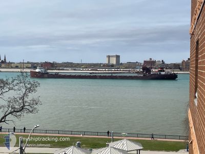
HERBERT C JACKSON
Self Discharging Bulk Carrier
Current Trip
USRRJ>CAMDB
| Time Travelled | 2 days |
|---|---|
| Remaining Time | --- |
| Distance Travelled | 278.57 nm |
| Remaining Distance | --- |
| AVG Speed | 8.9 Knopen |
| MAX Speed | 11.7 Knopen |
| AVG Wind | 9.1 knots |
| MAX Wind | 23 knots |
| MIN Temp | -11.2°C / 11.84°F |
| MAX Temp | 0.8°C / 33.44°F |
| Diepgang | 5.4 M |
| Positie ontvangen | 1 d geleden |
Current Position
| Lengtegraad | --- |
|---|---|
| Breedtegraat | --- |
| Status | Under way using engine |
| Snelheid | 6.2 Knopen |
| Koers | 355.5° |
| Gebied | --- |
| Station | T-AIS |
| Positie ontvangen | 1 d geleden |
Info
Information
The current position of HERBERT C JACKSON is in --- with coordinates 43.39104° / -82.21172° as reported on 2025-12-06 09:04 by AIS to our vessel tracker app. The vessel's current speed is 6.2 Knopen
The vessel HERBERT C JACKSON (IMO: 5148417, MMSI: 366904930) is a Self Discharging Bulk Carrier that was built in 1959 ( 66 Jaar oud ). It's sailing under the flag of [US] USA.
In this page you can find informations about the vessels current position, last detected port calls, and current voyage information. If the vessels is not in coverage by AIS you will find the latest position.
The current position of HERBERT C JACKSON is detected by our AIS receivers and we are not responsible for the reliability of the data. The last position was recorded while the vessel was in Coverage by the Ais receivers of our vessel tracking app.
The current draught of HERBERT C JACKSON as reported by AIS is 5.4 meters
Weather
| Temperature | -5.6°C / 21.92°F |
|---|---|
| Wind Speed | 12 knots |
| Direction | 275° W |
| Pressure | 1017.1 hPa |
| Humidity | 58.9 % |
| Cloud Coverage | 100 % |
Featured Company
Last Port Calls
| Port | Arrival | Departure | Time In Port |
|---|---|---|---|
| 2025-12-04 04:39 | 2025-12-04 18:13 | 13 h | |
| 2025-12-03 04:00 | 2025-12-03 21:06 | 17 h | |
| 2025-12-02 10:54 | 2025-12-02 22:27 | 11 h | |
| 2025-11-25 15:40 | 2025-11-28 16:58 | 3 d | |
| 2025-11-22 06:11 | 2025-11-22 20:11 | 14 h | |
| 2025-11-21 14:05 | 2025-11-21 22:38 | 8 h | |
| 2025-11-20 22:02 | 2025-11-21 08:50 | 10 h | |
| 2025-11-17 15:36 | 2025-11-18 02:30 | 10 h | |
| 2025-11-11 08:27 | 2025-11-12 00:26 | 15 h | |
| 2025-11-08 10:10 | 2025-11-08 19:42 | 9 h |
Most Visited Ports (Last year)
| Port | Arrivals | |
|---|---|---|
| 39 | ||
| 30 | ||
| 16 | ||
| 11 | ||
| 10 | ||
| 9 |
Last Trips
| Origin | Departure | Destination | Arrival | Distance | |
|---|---|---|---|---|---|
| 2025-12-03 21:06 | 2025-12-04 04:39 | 74.15 nm | |||
| 2025-12-02 22:27 | 2025-12-03 04:00 | 47.98 nm | |||
| 2025-11-28 16:58 | 2025-12-02 10:54 | 639.85 nm | |||
| 2025-11-22 20:11 | 2025-11-25 15:40 | 514.30 nm | |||
| 2025-11-21 22:38 | 2025-11-22 06:11 | 74.47 nm | |||
| 2025-11-21 08:50 | 2025-11-21 14:05 | 48.25 nm | |||
| 2025-11-18 02:30 | 2025-11-20 22:02 | 581.00 nm | |||
| 2025-11-12 00:26 | 2025-11-17 15:36 | 881.06 nm | |||
| 2025-11-08 19:42 | 2025-11-11 08:27 | 348.72 nm | |||
| 2025-11-08 03:30 | 2025-11-08 10:10 | 63.93 nm |
Events
| Tijd | Evenement | Details | Positie / Bestemming | Info |
|---|---|---|---|---|
| 2025-12-07 07:54 | Stop beweging |
45.91333 / -83.22334
USRRJ>CAMDB
|
Snelheid: Koers: -1° |
|
| 2025-12-06 09:10 | Status Changed | Default Under way using engine |
43.40015 / -82.21278
USRRJ>CAMDB
|
Snelheid: 6.2 kn Koers: 355.5° |
| 2025-12-06 09:04 | Status Changed | Under way using engine Default |
43.39104 / -82.21172
USRRJ>CAMDB
|
Snelheid: 6.4 kn Koers: 355° |
| 2025-12-06 09:04 | Buitenbereik |
43.39104 / -82.21172
|
Snelheid: 6.2 kn Koers: 355.5° |
|
| 2025-12-06 08:39 | Status Changed | Default Under way using engine |
43.32182 / -82.22465
USRRJ>CAMDB
|
Snelheid: 11.5 kn Koers: 9.5° |
| 2025-12-06 07:13 | Start beweging | 6.2 nm, North of PORT HURON |
43.09233 / -82.38701
USRRJ>CAMDB
|
Snelheid: 3.1 kn Koers: 99° |
| 2025-12-06 02:00 | Stop beweging | 6.18 nm, North of PORT HURON |
43.09266 / -82.39015
USRRJ>CAMDB
|
Snelheid: 0.3 kn Koers: 208° |
| 2025-12-06 01:39 | Start beweging | 6.71 nm, North East of PORT HURON |
43.09584 / -82.36620
USRRJ>CAMDB
|
Snelheid: 4.3 kn Koers: 252° |
| 2025-12-05 05:43 | Stop beweging | 6.78 nm, North East of PORT HURON |
43.09621 / -82.36325
USRRJ>CAMDB
|
Snelheid: 0.3 kn Koers: 161° |
| 2025-12-05 01:55 | Status Changed | Under way using engine Default |
42.59811 / -82.53759
USRRJ>CAMDB
|
Snelheid: 9 kn Koers: 36° |