
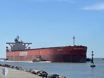
FRIENDSHIP
Bulk Carrier
Current Trip
CN LSN
| Time Travelled | 7 days |
|---|---|
| Remaining Time | --- |
| Distance Travelled | 1924.23 nm |
| Remaining Distance | --- |
| AVG Speed | 10.5 Knopen |
| MAX Speed | 14.3 Knopen |
| AVG Wind | 9.4 knots |
| MAX Wind | 19 knots |
| MIN Temp | 12.7°C / 54.86°F |
| MAX Temp | 31°C / 87.8°F |
| Diepgang | 18.3 M |
| Positie ontvangen | 6 d geleden |
Current Position
| Lengtegraad | 123.45543° |
|---|---|
| Breedtegraat | 34.09348° |
| Status | Under way using engine |
| Snelheid | 11.7 Knopen |
| Koers | 127° |
| Gebied | Yellow Sea |
| Station | T-AIS |
| Positie ontvangen | 6 d geleden |
Info
Information
The current position of FRIENDSHIP is in Yellow Sea with coordinates 34.09348° / 123.45543° as reported on 2024-04-26 23:31 by AIS to our vessel tracker app. The vessel's current speed is 11.7 Knopen
The vessel FRIENDSHIP (IMO: 9410454, MMSI: 636021000) is a Bulk Carrier that was built in 2009 ( 15 Jaar oud ). It's sailing under the flag of [LR] Liberia.
In this page you can find informations about the vessels current position, last detected port calls, and current voyage information. If the vessels is not in coverage by AIS you will find the latest position.
The current position of FRIENDSHIP is detected by our AIS receivers and we are not responsible for the reliability of the data. The last position was recorded while the vessel was in Coverage by the Ais receivers of our vessel tracking app.
The current draught of FRIENDSHIP as reported by AIS is 18.3 meters
Weather
| Temperature | 29.3°C / 84.74°F |
|---|---|
| Wind Speed | 6 knots |
| Direction | 38° NE |
| Pressure | 1008.2 hPa |
| Humidity | 70.8 % |
| Cloud Coverage | 100 % |
Featured Company
Events
| Tijd | Evenement | Details | Positie / Bestemming | Info |
|---|---|---|---|---|
| 2024-04-26 23:39 | Status Changed | Default Under way using engine |
34.07834 / 123.47833
CN LSN
|
Snelheid: 11.7 kn Koers: 127° |
| 2024-04-26 23:31 | Buitenbereik |
34.09348 / 123.45543
Yellow Sea
|
Snelheid: 11.7 kn Koers: 127° |
|
| 2024-04-26 23:29 | Status Changed | Under way using engine Default |
34.09643 / 123.45082
CN LSN
|
Snelheid: 11.7 kn Koers: 129° |
| 2024-04-26 23:21 | Status Changed | Default Under way using engine |
34.11500 / 123.42333
CN LSN
|
Snelheid: 11.7 kn Koers: 134° |
| 2024-04-26 23:03 | Wijzig zee gebeid | South Korean part of the Yellow Sea Malaysian part of the Singapore Strait |
34.14270 / 123.37360
Yellow Sea
|
Snelheid: 8.7 kn Koers: 69° |
| 2024-04-26 23:03 | Status Changed | Under way using engine Default |
34.14257 / 123.37302
CN LSN
|
Snelheid: 7 kn Koers: 17° |
| 2024-04-26 22:46 | Binnenbereik |
34.14270 / 123.37360
Yellow Sea
|
Snelheid: 8.7 kn Koers: 69° |
|
| 2024-04-26 04:12 | Start beweging |
35.04333 / 120.01770
CN LSN
|
Snelheid: 3.6 kn Koers: 133° |
|
| 2024-04-26 03:32 | Stop beweging |
35.05113 / 120.01373
CN LSN
|
Snelheid: 0.3 kn Koers: 202° |
|
| 2024-04-25 23:12 | Vertrekhaven |
|
35.06503 / 119.39692
CN LSN
|
Snelheid: 8 kn Koers: 127° |