
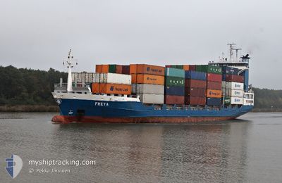
FREYA
Container Ship
Current Trip
BEZEE <> GBHUL
| Time Travelled | 1 day |
|---|---|
| Remaining Time | --- |
| Distance Travelled | 211.53 nm |
| Remaining Distance | --- |
| AVG Speed | 7.7 Knopen |
| MAX Speed | 17.1 Knopen |
| AVG Wind | 23.7 knots |
| MAX Wind | 28 knots |
| MIN Temp | 0.5°C / 32.9°F |
| MAX Temp | 5.8°C / 42.44°F |
| Diepgang | 5.4 M |
| Positie ontvangen | 15 m geleden |
Current Position
| Lengtegraad | --- |
|---|---|
| Breedtegraat | --- |
| Status | At anchor |
| Snelheid | 0.4 Knopen |
| Koers | 8° |
| Gebied | North Sea |
| Station | T-AIS |
| Positie ontvangen | 15 m geleden |
Info
Information
The current position of FREYA is in North Sea with coordinates 51.31154° / 2.57695° as reported on 2026-01-03 19:06 by AIS to our vessel tracker app. The vessel's current speed is 0.4 Knopen
The vessel FREYA (IMO: 9219874, MMSI: 244180000) is a Container Ship that was built in 2000 ( 26 Jaar oud ). It's sailing under the flag of [NL] Netherlands.
In this page you can find informations about the vessels current position, last detected port calls, and current voyage information. If the vessels is not in coverage by AIS you will find the latest position.
The current position of FREYA is detected by our AIS receivers and we are not responsible for the reliability of the data. The last position was recorded while the vessel was in Coverage by the Ais receivers of our vessel tracking app.
The current draught of FREYA as reported by AIS is 5.4 meters
Weather
| Temperature | 4.6°C / 40.28°F |
|---|---|
| Wind Speed | 21 knots |
| Direction | 315° NW |
| Pressure | 1009.8 hPa |
| Humidity | 69.1 % |
| Cloud Coverage | 100 % |
Featured Company
Last Port Calls
| Port | Arrival | Departure | Time In Port |
|---|---|---|---|
| 2025-12-31 06:00 | 2026-01-02 15:29 | 2 d | |
| 2025-12-30 06:34 | 2025-12-30 17:19 | 10 h | |
| 2025-12-24 06:43 | 2025-12-29 15:33 | 5 d | |
| 2025-12-23 09:11 | 2025-12-23 18:11 | 9 h | |
| 2025-12-21 08:13 | 2025-12-22 16:45 | 1 d | |
| 2025-12-20 09:37 | 2025-12-20 18:26 | 8 h | |
| 2025-12-19 08:03 | 2025-12-19 18:04 | 10 h | |
| 2025-12-18 09:36 | 2025-12-18 19:38 | 10 h | |
| 2025-12-17 06:52 | 2025-12-17 17:47 | 10 h | |
| 2025-12-16 07:22 | 2025-12-16 18:45 | 11 h |
Most Visited Ports (Last year)
| Port | Arrivals | |
|---|---|---|
| 124 | ||
| 123 | ||
| 1 |
Last Trips
| Origin | Departure | Destination | Arrival | Distance | |
|---|---|---|---|---|---|
| 2025-12-30 17:19 | 2025-12-31 06:00 | 209.77 nm | |||
| 2025-12-29 15:33 | 2025-12-30 06:34 | 209.65 nm | |||
| 2025-12-23 18:11 | 2025-12-24 06:43 | 209.56 nm | |||
| 2025-12-22 16:45 | 2025-12-23 09:11 | 218.34 nm | |||
| 2025-12-20 18:26 | 2025-12-21 08:13 | 209.93 nm | |||
| 2025-12-19 18:04 | 2025-12-20 09:37 | 218.53 nm | |||
| 2025-12-18 19:38 | 2025-12-19 08:03 | 208.55 nm | |||
| 2025-12-17 17:47 | 2025-12-18 09:36 | 215.85 nm | |||
| 2025-12-16 18:45 | 2025-12-17 06:52 | 211.40 nm | |||
| 2025-12-15 16:33 | 2025-12-16 07:22 | 200.68 nm |
Events
| Tijd | Evenement | Details | Positie / Bestemming | Info |
|---|---|---|---|---|
| 2026-01-03 19:18 | Status Changed | At anchor Default |
51.31147 / 2.57731
BEZEE <> GBHUL
|
Snelheid: 0.3 kn Koers: 7° |
| 2026-01-03 19:12 | Status Changed | Default At anchor |
51.31158 / 2.57701
BEZEE <> GBHUL
|
Snelheid: 0.4 kn Koers: 8° |
| 2026-01-03 19:06 | Status Changed | At anchor Default |
51.31154 / 2.57695
BEZEE <> GBHUL
|
Snelheid: 0.6 kn Koers: 9° |
| 2026-01-03 19:03 | Status Changed | Default At anchor |
51.31139 / 2.57722
BEZEE <> GBHUL
|
Snelheid: 0.4 kn Koers: 8° |
| 2026-01-03 18:36 | Status Changed | At anchor Default |
51.31137 / 2.57742
BEZEE <> GBHUL
|
Snelheid: 0.1 kn Koers: 2° |
| 2026-01-03 18:30 | Status Changed | Default At anchor |
51.31139 / 2.57748
BEZEE <> GBHUL
|
Snelheid: 0.1 kn Koers: 4° |
| 2026-01-03 18:18 | Status Changed | At anchor Default |
51.31132 / 2.57756
BEZEE <> GBHUL
|
Snelheid: 0.1 kn Koers: 6° |
| 2026-01-03 18:09 | Status Changed | Default At anchor |
51.31138 / 2.57747
BEZEE <> GBHUL
|
Snelheid: 0.1 kn Koers: 0° |
| 2026-01-03 18:03 | Status Changed | At anchor Under way using engine |
51.31141 / 2.57773
BEZEE <> GBHUL
|
Snelheid: 0.2 kn Koers: 356° |
| 2026-01-03 18:01 | Stop beweging | 12.49 nm, North West of NIEUWPOORT |
51.31133 / 2.57778
BEZEE <> GBHUL
|
Snelheid: 0.3 kn Koers: 8° |