
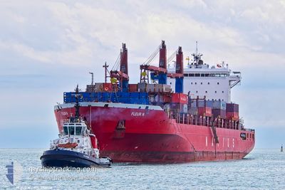
FLEUR N
Container Ship
Current Trip
| Time Travelled | 16 h, 24 mins |
|---|---|
| Remaining Time | --- |
| Distance Travelled | 22.27 nm |
| Remaining Distance | 4.81 nm |
| AVG Speed | 8.7 Knopen |
| MAX Speed | 13.8 Knopen |
| AVG Wind | 8 knots |
| MAX Wind | 11.3 knots |
| MIN Temp | 4.8°C / 40.64°F |
| MAX Temp | 8.9°C / 48.02°F |
| Diepgang | 12.3 M |
| Positie ontvangen | 4 m geleden |
Current Position
| Lengtegraad | --- |
|---|---|
| Breedtegraat | --- |
| Status | At anchor |
| Snelheid | |
| Koers | 351° |
| Gebied | Strait of Gibraltar |
| Station | T-AIS |
| Positie ontvangen | 4 m geleden |
Info
Information
The current position of FLEUR N is in Strait of Gibraltar with coordinates 36.08572° / -5.41061° as reported on 2026-01-07 00:12 by AIS to our vessel tracker app. The vessel's current speed is 0 Knopen and is heading at the port of ALGECIRAS. The estimated time of arrival as calculated by MyShipTracking vessel tracking app is 2026-01-07 00:40 LT
The vessel FLEUR N (IMO: 9509138, MMSI: 636019931) is a Container Ship that was built in 2012 ( 14 Jaar oud ). It's sailing under the flag of [LR] Liberia.
In this page you can find informations about the vessels current position, last detected port calls, and current voyage information. If the vessels is not in coverage by AIS you will find the latest position.
The current position of FLEUR N is detected by our AIS receivers and we are not responsible for the reliability of the data. The last position was recorded while the vessel was in Coverage by the Ais receivers of our vessel tracking app.
The current draught of FLEUR N as reported by AIS is 12.3 meters
Weather
| Temperature | 7.1°C / 44.78°F |
|---|---|
| Wind Speed | 8 knots |
| Direction | 295° WNW |
| Pressure | 1023.8 hPa |
| Humidity | 57.6 % |
| Cloud Coverage | 29 % |
Featured Company
Last Port Calls
| Port | Arrival | Departure | Time In Port |
|---|---|---|---|
| 2026-01-05 03:09 | 2026-01-06 08:53 | 1 d | |
| 2025-12-23 23:11 | 2025-12-26 09:26 | 2 d | |
| 2025-12-21 11:27 | 2025-12-22 13:27 | 1 d | |
| 2025-11-20 05:40 | 2025-11-21 02:31 | 20 h | |
| 2025-11-11 00:58 | 2025-11-13 00:07 | 1 d |
Most Visited Ports (Last year)
| Port | Arrivals | |
|---|---|---|
| 12 | ||
| 7 | ||
| 6 | ||
| 5 | ||
| 5 | ||
| 4 |
Last Trips
| Origin | Departure | Destination | Arrival | Distance | |
|---|---|---|---|---|---|
| 2025-12-26 09:26 | 2026-01-05 03:09 | 2162.17 nm | |||
| 2025-12-22 13:27 | 2025-12-23 23:11 | 99.27 nm | |||
| 2025-11-21 02:31 | 2025-12-21 11:27 | 2109.50 nm | |||
| 2025-11-13 00:07 | 2025-11-20 05:40 | 1990.17 nm | |||
| 2025-10-03 19:40 | 2025-11-11 00:58 | 242.71 nm |
Events
| Tijd | Evenement | Details | Positie / Bestemming | Info |
|---|---|---|---|---|
| 2026-01-06 23:54 | Status Changed | At anchor Default |
36.08573 / -5.41059
ESALG
|
Snelheid: 0.1 kn Koers: 345° |
| 2026-01-06 23:48 | Status Changed | Default At anchor |
36.08561 / -5.41046
ESALG
|
Snelheid: 0.1 kn Koers: 348° |
| 2026-01-06 23:45 | Status Changed | At anchor Default |
36.08556 / -5.41052
ESALG
|
Snelheid: 0.2 kn Koers: 353° |
| 2026-01-06 23:42 | Status Changed | Default At anchor |
36.08561 / -5.41060
ESALG
|
Snelheid: 0.2 kn Koers: 4° |
| 2026-01-06 22:58 | Stop beweging | 3.09 nm, South of ALGECIRAS |
36.08565 / -5.41059
ESALG
|
Snelheid: 0.3 kn Koers: 347° |
| 2026-01-06 22:57 | Status Changed | At anchor Under way using engine |
36.08572 / -5.41057
ESALG
|
Snelheid: 0.4 kn Koers: 342° |
| 2026-01-06 21:53 | Wijzig zee gebeid | Spanish part of the Strait of Gibraltar Moroccan part of the Strait of Gibraltar |
35.99989 / -5.37564
Strait of Gibraltar
ESALG
|
Snelheid: 9.5 kn Koers: 2.3° |
| 2026-01-06 21:44 | ETA Changed | 2026/01/06 23:40 2026/01/06 22:00 |
35.98304 / -5.39299
ESALG
|
Snelheid: 12.1 kn Koers: 58.8° |
| 2026-01-06 20:52 | Status Changed | Under way using engine Default |
35.87203 / -5.53464
ESALG
|
Snelheid: 3.2 kn Koers: 16° |
| 2026-01-06 20:51 | Status Changed | Default Under way using engine |
35.87081 / -5.53510
ESALG
|
Snelheid: 0.5 kn Koers: 27° |