
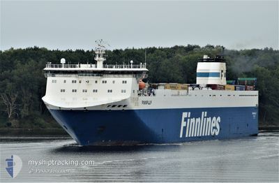
FINNPULP
Ro-Ro Cargo
Current Trip
| Trip Time | 12 h, 44 mins |
|---|---|
| Trip Distance | 159.27 nm |
| AVG Speed | 12.3 Knopen |
| MAX Speed | 13.5 Knopen |
| Diepgang | 6.1 M |
| AVG Wind | 9.7 knots |
| MAX Wind | 17.7 knots |
| MIN Temp | 2.6°C / 36.68°F |
| MAX Temp | 6.1°C / 42.98°F |
| Positie ontvangen | 2 h, 24 m geleden |
Current Position
| Lengtegraad | --- |
|---|---|
| Breedtegraat | --- |
| Status | Under way using engine |
| Snelheid | 14.5 Knopen |
| Koers | 217° |
| Gebied | Baltic Sea |
| Station | T-AIS |
| Positie ontvangen | 2 h, 24 m geleden |
Info
Information
The current position of FINNPULP is in Baltic Sea with coordinates 53.97601° / 10.90949° as reported on 2025-12-06 07:09 by AIS to our vessel tracker app. The vessel's current speed is 14.5 Knopen and is currently inside the port of TRAVEMUNDE.
The vessel FINNPULP (IMO: 9212644, MMSI: 230643000) is a Ro-Ro Cargo that was built in 2002 ( 23 Jaar oud ). It's sailing under the flag of [FI] Finland.
In this page you can find informations about the vessels current position, last detected port calls, and current voyage information. If the vessels is not in coverage by AIS you will find the latest position.
The current position of FINNPULP is detected by our AIS receivers and we are not responsible for the reliability of the data. The last position was recorded while the vessel was in Coverage by the Ais receivers of our vessel tracking app.
The current draught of FINNPULP as reported by AIS is 6.1 meters
Weather
| Temperature | 2.8°C / 37.04°F |
|---|---|
| Wind Speed | 11 knots |
| Direction | 156° SSE |
| Pressure | 1007.2 hPa |
| Humidity | 85.6 % |
| Cloud Coverage | 100 % |
Featured Company
Last Port Calls
| Port | Arrival | Departure | Time In Port |
|---|---|---|---|
| 2025-12-06 08:17 | |||
| 2025-12-05 06:24 | 2025-12-05 19:33 | 13 h | |
| 2025-12-04 15:17 | 2025-12-04 21:20 | 6 h | |
| 2025-12-03 05:36 | 2025-12-03 09:46 | 4 h | |
| 2025-12-01 06:25 | 2025-12-02 21:00 | 1 d | |
| 2025-11-29 08:17 | 2025-11-29 16:01 | 7 h | |
| 2025-11-28 06:11 | 2025-11-28 18:49 | 12 h | |
| 2025-11-27 08:21 | 2025-11-27 14:05 | 5 h | |
| 2025-11-24 06:34 | 2025-11-25 20:30 | 1 d | |
| 2025-11-22 09:16 | 2025-11-22 16:09 | 6 h |
Last Trips
| Origin | Departure | Destination | Arrival | Distance | |
|---|---|---|---|---|---|
| 2025-12-05 19:33 | 2025-12-06 08:17 | 159.27 nm | |||
| 2025-12-04 21:20 | 2025-12-05 06:24 | 159.89 nm | |||
| 2025-12-03 09:46 | 2025-12-04 15:17 | 565.09 nm | |||
| 2025-12-02 21:00 | 2025-12-03 05:36 | 87.32 nm | |||
| 2025-11-29 16:01 | 2025-12-01 06:25 | 630.64 nm | |||
| 2025-11-28 18:49 | 2025-11-29 08:17 | 158.93 nm | |||
| 2025-11-27 14:05 | 2025-11-28 06:11 | 160.45 nm | |||
| 2025-11-25 20:30 | 2025-11-27 08:21 | 634.84 nm | |||
| 2025-11-22 16:09 | 2025-11-24 06:34 | 631.00 nm | |||
| 2025-11-21 20:05 | 2025-11-22 09:16 | 159.64 nm |
Events
| Tijd | Evenement | Details | Positie / Bestemming | Info |
|---|---|---|---|---|
| 2025-12-06 07:45 | Stop beweging |
53.94535 / 10.85961
[DE] TRAVEMUNDE
|
Snelheid: Koers: 359° |
|
| 2025-12-06 07:17 | Status Changed | Default Under way using engine |
53.95987 / 10.88471
[DE] TRAVEMUNDE
|
Snelheid: 14.5 kn Koers: 217° |
| 2025-12-06 07:17 | Aankomsthaven |
|
53.95987 / 10.88471
[DE] TRAVEMUNDE
|
Snelheid: 14.5 kn Koers: 217° |
| 2025-12-06 07:09 | Buitenbereik |
53.97601 / 10.90949
Baltic Sea
[DE] TRAVEMUNDE
|
Snelheid: 14.5 kn Koers: 217° |
|
| 2025-12-06 03:10 | Wijzig zee gebeid | German part of the Baltic Sea Danish part of the Baltic Sea |
54.63706 / 11.02810
Baltic Sea
DETRV
|
Snelheid: 12.5 kn Koers: 125.9° |
| 2025-12-06 02:29 | Wijzig zee gebeid | Danish part of the Baltic Sea Danish part of the Kattegat |
54.73007 / 10.86976
Baltic Sea
DETRV
|
Snelheid: 12.2 kn Koers: 177.1° |
| 2025-12-05 22:19 | Status Changed | Under way using engine Default |
55.52379 / 10.85355
DETRV
|
Snelheid: 12.8 kn Koers: 159° |
| 2025-12-05 21:57 | Status Changed | Default Under way using engine |
55.59115 / 10.80075
DETRV
|
Snelheid: 12.6 kn Koers: 151° |
| 2025-12-05 20:47 | Status Changed | Under way using engine Default |
55.75830 / 10.52638
DETRV
|
Snelheid: 12.3 kn Koers: 151° |
| 2025-12-05 20:45 | Status Changed | Default Under way using engine |
55.76426 / 10.52032
DETRV
|
Snelheid: 12.2 kn Koers: 149.5° |