
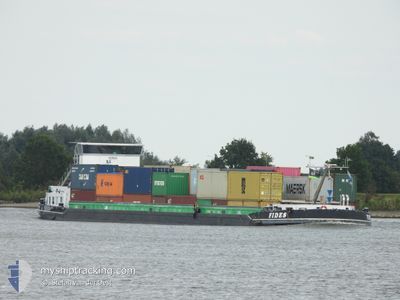
FIDES
Cargo
Current Trip
| Trip Time | 1 day |
|---|---|
| Trip Distance | 114.79 nm |
| AVG Speed | 6.6 Knopen |
| MAX Speed | 8.4 Knopen |
| Diepgang | 0 M |
| AVG Wind | 12.5 knots |
| MAX Wind | 18 knots |
| MIN Temp | 7.7°C / 45.86°F |
| MAX Temp | 9.5°C / 49.1°F |
| Positie ontvangen | 1 m geleden |
Current Position
| Lengtegraad | --- |
|---|---|
| Breedtegraat | --- |
| Status | Under way using engine |
| Snelheid | |
| Koers | --- |
| Gebied | North Sea |
| Station | T-AIS |
| Positie ontvangen | 1 m geleden |
Info
Information
The current position of FIDES is in North Sea with coordinates 53.22714° / 6.59255° as reported on 2025-12-07 10:42 by AIS to our vessel tracker app. The vessel's current speed is 0 Knopen and is currently inside the port of GRONINGEN.
The vessel FIDES (MMSI: 244650105) is a Cargo It's sailing under the flag of [NL] Netherlands.
In this page you can find informations about the vessels current position, last detected port calls, and current voyage information. If the vessels is not in coverage by AIS you will find the latest position.
The current position of FIDES is detected by our AIS receivers and we are not responsible for the reliability of the data. The last position was recorded while the vessel was in Coverage by the Ais receivers of our vessel tracking app.
Weather
| Temperature | 9.2°C / 48.56°F |
|---|---|
| Wind Speed | 11 knots |
| Direction | 215° SW |
| Pressure | 1006.2 hPa |
| Humidity | 90.9 % |
| Cloud Coverage | 100 % |
Featured Company
Last Port Calls
| Port | Arrival | Departure | Time In Port |
|---|---|---|---|
| 2025-12-07 11:35 | |||
| 2025-12-06 10:44 | 2025-12-06 11:19 | 35 m | |
| 2025-12-05 20:56 | 2025-12-05 23:17 | 2 h | |
| 2025-12-05 18:46 | 2025-12-05 20:04 | 1 h | |
| 2025-12-05 16:38 | 2025-12-05 18:16 | 1 h | |
| 2025-12-05 15:32 | 2025-12-05 16:07 | 35 m | |
| 2025-12-05 11:45 | 2025-12-05 14:48 | 3 h | |
| 2025-12-05 09:55 | 2025-12-05 10:31 | 36 m | |
| 2025-12-05 07:10 | 2025-12-05 08:51 | 1 h | |
| 2025-12-04 22:41 | 2025-12-05 07:05 | 8 h |
Most Visited Ports (Last year)
| Port | Arrivals | |
|---|---|---|
| 171 | ||
| 151 | ||
| 146 | ||
| 145 | ||
| 83 | ||
| 73 |
Last Trips
| Origin | Departure | Destination | Arrival | Distance | |
|---|---|---|---|---|---|
| 2025-12-06 11:19 | 2025-12-07 11:35 | 114.79 nm | |||
| 2025-12-05 23:17 | 2025-12-06 10:44 | 29.38 nm | |||
| 2025-12-05 20:04 | 2025-12-05 20:56 | 3.87 nm | |||
| 2025-12-05 18:16 | 2025-12-05 18:46 | 3.75 nm | |||
| 2025-12-05 16:07 | 2025-12-05 16:38 | 3.70 nm | |||
| 2025-12-05 14:48 | 2025-12-05 15:32 | 4.80 nm | |||
| 2025-12-05 10:31 | 2025-12-05 11:45 | 9.07 nm | |||
| 2025-12-05 08:51 | 2025-12-05 09:55 | 7.33 nm | |||
| 2025-12-05 07:05 | 2025-12-05 07:10 | 0.39 nm | |||
| 2025-12-04 21:45 | 2025-12-04 22:41 | 7.02 nm |
Events
| Tijd | Evenement | Details | Positie / Bestemming | Info |
|---|---|---|---|---|
| 2025-12-07 10:35 | Stop beweging |
53.22710 / 6.59255
[NL] GRONINGEN
|
Snelheid: 0.3 kn Koers: 511° |
|
| 2025-12-07 10:35 | Aankomsthaven |
|
53.22713 / 6.59251
[NL] GRONINGEN
|
Snelheid: 1.2 kn Koers: 511° |
| 2025-12-07 08:36 | Start beweging | 2.8 nm, West of BRILTIL |
53.24915 / 6.31370
SEINEHAVEN
|
Snelheid: 3.5 kn Koers: 80.7° |
| 2025-12-07 08:27 | Stop beweging | 2.91 nm, West of BRILTIL |
53.24885 / 6.31062
SEINEHAVEN
|
Snelheid: 0.3 kn Koers: 511° |
| 2025-12-07 08:24 | Start beweging | 3.02 nm, West of BRILTIL |
53.24847 / 6.30767
SEINEHAVEN
|
Snelheid: 3.7 kn Koers: 76.2° |
| 2025-12-07 08:17 | Stop beweging | 3.13 nm, West of BRILTIL |
53.24801 / 6.30466
SEINEHAVEN
|
Snelheid: 0.3 kn Koers: 511° |
| 2025-12-07 05:35 | Status Changed | Under way using engine Default |
53.16745 / 5.93346
SEINEHAVEN
|
Snelheid: Koers: -1° |
| 2025-12-07 05:35 | Start beweging | 1.52 nm, North East of WARTEN |
53.16745 / 5.93346
SEINEHAVEN
|
Snelheid: 5.8 kn Koers: 11.2° |
| 2025-12-07 05:20 | Binnenbereik |
53.17068 / 5.93525
North Sea
|
Snelheid: 6.3 kn Koers: 26.3° |
|
| 2025-12-06 21:43 | Buitenbereik |
53.05069 / 5.78192
North Sea
|
Snelheid: 6.1 kn Koers: 47.1° |