
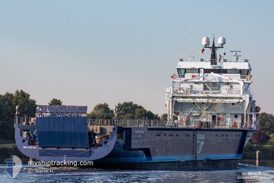
EASTERN ROCK
Cargo
Current Trip
| Time Travelled | 4 days |
|---|---|
| Remaining Time | --- |
| Distance Travelled | 1069.86 nm |
| Remaining Distance | --- |
| AVG Speed | 10.1 Knopen |
| MAX Speed | 14 Knopen |
| AVG Wind | 14.6 knots |
| MAX Wind | 28.6 knots |
| MIN Temp | 10.7°C / 51.26°F |
| MAX Temp | 15.5°C / 59.9°F |
| Diepgang | 4.4 M |
| Positie ontvangen | Nu |
Current Position
| Lengtegraad | -10.05335° |
|---|---|
| Breedtegraat | 38.55074° |
| Status | Under way using engine |
| Snelheid | 11 Knopen |
| Koers | 168.3° |
| Gebied | North Atlantic Ocean |
| Station | T-AIS |
| Positie ontvangen | Nu |
Info
Information
The current position of EASTERN ROCK is in North Atlantic Ocean with coordinates 38.55074° / -10.05335° as reported on 2024-05-15 12:08 by AIS to our vessel tracker app. The vessel's current speed is 11 Knopen and is heading at the port of MOTRIL. The estimated time of arrival as calculated by MyShipTracking vessel tracking app is 2024-05-16 20:00 LT
The vessel EASTERN ROCK (IMO: 9857119, MMSI: 244347000) is a Cargo It's sailing under the flag of [NL] Netherlands.
In this page you can find informations about the vessels current position, last detected port calls, and current voyage information. If the vessels is not in coverage by AIS you will find the latest position.
The current position of EASTERN ROCK is detected by our AIS receivers and we are not responsible for the reliability of the data. The last position was recorded while the vessel was in Coverage by the Ais receivers of our vessel tracking app.
The current draught of EASTERN ROCK as reported by AIS is 4.4 meters
Weather
| Temperature | 15.5°C / 59.9°F |
|---|---|
| Wind Speed | 14 knots |
| Direction | 312° NW |
| Pressure | 1015.2 hPa |
| Humidity | 67.8 % |
| Cloud Coverage | 31 % |
Featured Company
Last Port Calls
| Port | Arrival | Departure | Time In Port |
|---|---|---|---|
| 2024-05-09 21:31 | 2024-05-11 06:22 | 1 d | |
| 2024-05-05 16:16 | 2024-05-06 22:34 | 1 d | |
| 2024-05-01 17:01 | 2024-05-01 22:31 | 5 h | |
| 2024-04-30 19:03 | 2024-04-30 19:48 | 44 m | |
| 2024-04-28 17:34 | 2024-04-29 12:03 | 18 h | |
| 2024-04-21 16:47 | 2024-04-22 17:54 | 1 d | |
| 2024-04-15 06:24 | 2024-04-16 00:31 | 18 h | |
| 2024-04-09 05:05 | 2024-04-09 17:55 | 12 h | |
| 2024-04-02 17:21 | 2024-04-03 23:21 | 1 d | |
| 2024-03-24 04:06 | 2024-03-25 16:43 | 1 d |
Most Visited Ports (Last year)
| Port | Arrivals | |
|---|---|---|
| 3 | ||
| 3 | ||
| 2 | ||
| 2 | ||
| 2 | ||
| 2 |
Last Trips
| Origin | Departure | Destination | Arrival | Distance | |
|---|---|---|---|---|---|
| 2024-05-06 22:34 | 2024-05-09 21:31 | 762.39 nm | |||
| 2024-05-01 22:31 | 2024-05-05 16:16 | 942.48 nm | |||
| 2024-04-30 19:48 | 2024-05-01 17:01 | 186.71 nm | |||
| 2024-04-29 12:03 | 2024-04-30 19:03 | 377.21 nm | |||
| 2024-04-22 17:54 | 2024-04-28 17:34 | 1403.36 nm | |||
| 2024-04-16 00:31 | 2024-04-21 16:47 | 1317.73 nm | |||
| 2024-04-09 17:55 | 2024-04-15 06:24 | 1332.02 nm | |||
| 2024-04-03 23:21 | 2024-04-09 05:05 | 1320.33 nm | |||
| 2024-03-25 16:43 | 2024-04-02 17:21 | 1197.45 nm | |||
| 2024-03-19 18:11 | 2024-03-24 04:06 | 1030.14 nm |
Events
| Tijd | Evenement | Details | Positie / Bestemming | Info |
|---|---|---|---|---|
| 2024-05-15 05:37 | Status Changed | Under way using engine Default |
39.73737 / -10.10037
MOTRIL
|
Snelheid: 10.7 kn Koers: 178° |
| 2024-05-15 05:30 | Status Changed | Default Under way using engine |
39.75538 / -10.10055
MOTRIL
|
Snelheid: 11 kn Koers: 177.1° |
| 2024-05-15 05:11 | Gevonden in zee | Portuguese part of the North Atlantic Ocean |
39.81376 / -10.10141
North Atlantic Ocean
MOTRIL
|
Snelheid: 10.2 kn Koers: 178° |
| 2024-05-15 05:10 | Status Changed | Under way using engine Default |
39.81494 / -10.10145
MOTRIL
|
Snelheid: 10.5 kn Koers: 178° |
| 2024-05-15 05:10 | Binnenbereik |
39.81376 / -10.10141
North Atlantic Ocean
MOTRIL
|
Snelheid: 10.2 kn Koers: 178° |
|
| 2024-05-13 15:19 | Status Changed | Default Under way using engine |
45.32787 / -8.85828
MOTRIL
|
Snelheid: 9.2 kn Koers: 200.6° |
| 2024-05-13 15:17 | Buitenbereik |
45.33130 / -8.85672
North Atlantic Ocean
MOTRIL
|
Snelheid: 9.2 kn Koers: 200.6° |
|
| 2024-05-13 12:42 | Wijzig zee gebeid | Spanish part of the North Atlantic Ocean French part of the Celtic Sea |
45.71801 / -8.68157
North Atlantic Ocean
MOTRIL
|
Snelheid: 9.3 kn Koers: 198.6° |
| 2024-05-13 12:41 | Status Changed | Under way using engine Default |
45.72037 / -8.68060
MOTRIL
|
Snelheid: 9 kn Koers: 198° |
| 2024-05-13 12:33 | Binnenbereik |
45.71801 / -8.68157
North Atlantic Ocean
MOTRIL
|
Snelheid: 9.3 kn Koers: 198.6° |