
DOGAN
General Cargo
Current Trip
| Time Travelled | 25 days |
|---|---|
| Remaining Time | --- |
| Distance Travelled | 401.73 nm |
| Remaining Distance | --- |
| AVG Speed | 8.8 Knopen |
| MAX Speed | 13.6 Knopen |
| AVG Wind | 7.3 knots |
| MAX Wind | 16 knots |
| MIN Temp | 8.6°C / 47.48°F |
| MAX Temp | 29.7°C / 85.46°F |
| Diepgang | 5.3 M |
| Positie ontvangen | 1 m geleden |
Current Position
| Lengtegraad | 29.20336° |
|---|---|
| Breedtegraat | 40.87447° |
| Status | At anchor |
| Snelheid | |
| Koers | 22° |
| Gebied | Sea of Marmara |
| Station | T-AIS |
| Positie ontvangen | 1 m geleden |
Info
Information
The current position of DOGAN is in Sea of Marmara with coordinates 40.87447° / 29.20336° as reported on 2024-04-27 07:41 by AIS to our vessel tracker app. The vessel's current speed is 0 Knopen and is heading at the port of TERMINI IMERESE. The estimated time of arrival as calculated by MyShipTracking vessel tracking app is 2024-05-01 07:00 LT
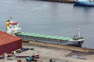
The vessel DOGAN (IMO: 9100152, MMSI: 304376000) is a General Cargo that was built in 1994 ( 30 Jaar oud ). It's sailing under the flag of [AG] Antigua Barbuda.
In this page you can find informations about the vessels current position, last detected port calls, and current voyage information. If the vessels is not in coverage by AIS you will find the latest position.
The current position of DOGAN is detected by our AIS receivers and we are not responsible for the reliability of the data. The last position was recorded while the vessel was in Coverage by the Ais receivers of our vessel tracking app.
The current draught of DOGAN as reported by AIS is 5.3 meters
Weather
| Temperature | 15.2°C / 59.36°F |
|---|---|
| Wind Speed | 14 knots |
| Direction | 83° E |
| Pressure | 1016.9 hPa |
| Humidity | 78.8 % |
| Cloud Coverage | 80 % |
Featured Company
Last Port Calls
| Port | Arrival | Departure | Time In Port |
|---|---|---|---|
| 2024-04-01 05:05 | 2024-04-01 09:45 | 4 h | |
| 2024-03-28 05:33 | 2024-03-28 22:34 | 17 h | |
| 2024-03-21 16:21 | 2024-03-23 01:13 | 1 d | |
| 2024-03-11 09:11 | 2024-03-12 07:00 | 21 h | |
| 2024-03-04 00:36 | |||
| 2024-02-28 11:45 | 2024-02-29 10:53 | 23 h | |
| 2024-02-13 13:14 | 2024-02-14 04:52 | 15 h | |
| 2024-02-04 10:30 | 2024-02-08 23:47 | 4 d |
Last Trips
| Origin | Departure | Destination | Arrival | Distance | |
|---|---|---|---|---|---|
| 2024-03-29 02:34 | 2024-04-01 08:05 | 574.74 nm | |||
| 2024-03-23 03:13 | 2024-03-28 09:33 | 652.06 nm | |||
| 2024-03-12 10:00 | 2024-03-21 18:21 | 474.17 nm | |||
| 2024-02-29 13:53 | 2024-03-04 04:36 | 505.02 nm | |||
| 2024-02-14 06:52 | 2024-02-28 14:45 | 415.29 nm | |||
| 2024-02-09 03:47 | 2024-02-13 15:14 | 560.70 nm | |||
| 2024-01-29 08:55 | 2024-02-04 14:30 | 671.43 nm |
Events
| Tijd | Evenement | Details | Positie / Bestemming | Info |
|---|---|---|---|---|
| 2024-04-27 05:36 | Status Changed | At anchor Under way using engine |
40.87536 / 29.20374
ITTRI
|
Snelheid: 0.5 kn Koers: 23° |
| 2024-04-27 05:33 | Stop beweging | 0.37 nm, South of KARTAL |
40.87557 / 29.20357
ITTRI
|
Snelheid: 0.3 kn Koers: 47° |
| 2024-04-27 03:58 | Start beweging | 1.59 nm, East of ZEYTINBURNU |
40.97183 / 28.92661
ITTRI
|
Snelheid: 5 kn Koers: 106.8° |
| 2024-04-27 03:54 | Status Changed | Under way using engine At anchor |
40.97160 / 28.92330
ITTRI
|
Snelheid: 0.1 kn Koers: 359° |
| 2024-04-27 01:24 | Status Changed | At anchor Under way using engine |
40.97205 / 28.92356
ITTRI
|
Snelheid: 0.2 kn Koers: 359° |
| 2024-04-27 01:24 | Stop beweging | 1.46 nm, East of ZEYTINBURNU |
40.97205 / 28.92357
ITTRI
|
Snelheid: 0.2 kn Koers: 359° |
| 2024-04-26 23:20 | Wijzig zee gebeid | Turkish part of the Sea of Marmara Turkish part of the Black Sea |
41.22833 / 29.12624
Sea of Marmara
ITTRI
|
Snelheid: 8.8 kn Koers: 176.5° |
| 2024-04-26 22:40 | Start beweging | 3.04 nm, North West of RUMELI FENERI |
41.27007 / 29.06985
ITTRI
|
Snelheid: 5.9 kn Koers: 102.6° |
| 2024-04-26 22:35 | Status Changed | Under way using engine At anchor |
41.27163 / 29.06358
ITTRI
|
Snelheid: 0.5 kn Koers: 129° |
| 2024-04-26 10:59 | Destination Changed | ITTRI TURKELI |
41.27050 / 29.06661
ITTRI
|
Snelheid: 0.1 kn Koers: 319° |