
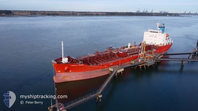
CHEMICAL RANGER
Tanker
Current Trip
| Time Travelled | 18 h, 26 mins |
|---|---|
| Remaining Time | 4 days |
| Distance Travelled | 116.88 nm |
| Remaining Distance | 1379.87 nm |
| AVG Speed | 11.4 Knopen |
| MAX Speed | 15.1 Knopen |
| AVG Wind | 17.3 knots |
| MAX Wind | 20.7 knots |
| MIN Temp | 17.1°C / 62.78°F |
| MAX Temp | 19.6°C / 67.28°F |
| Diepgang | 9.4 M |
| Positie ontvangen | 15 h, 25 m geleden |
Current Position
| Lengtegraad | --- |
|---|---|
| Breedtegraat | --- |
| Status | Under way using engine |
| Snelheid | 11.7 Knopen |
| Koers | 282.4° |
| Gebied | Mediterranean Sea - Eastern Basin |
| Station | T-AIS |
| Positie ontvangen | 15 h, 25 m geleden |
Info
Information
The current position of CHEMICAL RANGER is in Mediterranean Sea - Eastern Basin with coordinates 32.96234° / 34.42388° as reported on 2026-01-05 12:37 by AIS to our vessel tracker app. The vessel's current speed is 11.7 Knopen and is heading at the port of GENOVA. The estimated time of arrival as calculated by MyShipTracking vessel tracking app is 2026-01-10 16:19 LT
The vessel CHEMICAL RANGER (IMO: 9940746, MMSI: 538010423) is a Tanker It's sailing under the flag of [MH] Marshall Is.
In this page you can find informations about the vessels current position, last detected port calls, and current voyage information. If the vessels is not in coverage by AIS you will find the latest position.
The current position of CHEMICAL RANGER is detected by our AIS receivers and we are not responsible for the reliability of the data. The last position was recorded while the vessel was in Coverage by the Ais receivers of our vessel tracking app.
The current draught of CHEMICAL RANGER as reported by AIS is 9.4 meters
Weather
| Temperature | 17.9°C / 64.22°F |
|---|---|
| Wind Speed | 6 knots |
| Direction | 222° SW |
| Pressure | 1019.1 hPa |
| Humidity | 65.1 % |
| Cloud Coverage | 100 % |
Featured Company
Last Port Calls
| Port | Arrival | Departure | Time In Port |
|---|---|---|---|
| 2025-12-30 14:46 | 2026-01-05 11:36 | 5 d | |
| 2025-12-20 10:16 | 2025-12-22 04:28 | 1 d | |
| 2025-12-19 15:30 | 2025-12-20 08:26 | 16 h | |
| 2025-12-18 19:02 | 2025-12-19 15:00 | 19 h | |
| 2025-12-01 12:08 | 2025-12-04 13:48 | 3 d | |
| 2025-11-28 16:04 | 2025-11-29 16:34 | 1 d | |
| 2025-11-21 22:19 | 2025-11-25 18:42 | 3 d | |
| 2025-11-20 12:34 | 2025-11-21 20:20 | 1 d | |
| 2025-11-03 10:36 | 2025-11-07 20:23 | 4 d | |
| 2025-11-01 17:20 |
Most Visited Ports (Last year)
| Port | Arrivals | |
|---|---|---|
| 13 | ||
| 11 | ||
| 6 | ||
| 5 | ||
| 5 | ||
| 4 |
Last Trips
| Origin | Departure | Destination | Arrival | Distance | |
|---|---|---|---|---|---|
| 2025-12-22 04:28 | 2025-12-30 14:46 | 1194.07 nm | |||
| 2025-12-20 08:26 | 2025-12-20 10:16 | 13.18 nm | |||
| 2025-12-19 15:00 | 2025-12-19 15:30 | 2.45 nm | |||
| 2025-12-04 13:48 | 2025-12-18 19:02 | 3341.02 nm | |||
| 2025-11-29 16:34 | 2025-12-01 12:08 | 413.80 nm | |||
| 2025-11-25 18:42 | 2025-11-28 16:04 | 275.03 nm | |||
| 2025-11-21 20:20 | 2025-11-21 22:19 | 14.54 nm | |||
| 2025-11-07 20:23 | 2025-11-20 12:34 | 3354.65 nm | |||
| 2025-11-01 17:20 | 2025-11-03 10:36 | 22.90 nm |
Events
| Tijd | Evenement | Details | Positie / Bestemming | Info |
|---|---|---|---|---|
| 2026-01-05 12:40 | Status Changed | Default Under way using engine |
32.96433 / 34.40981
ITGOA
|
Snelheid: 11.7 kn Koers: 282.4° |
| 2026-01-05 12:37 | Buitenbereik |
32.96234 / 34.42388
Mediterranean Sea - Eastern Basin
ITGOA
|
Snelheid: 11.7 kn Koers: 282.4° |
|
| 2026-01-05 10:10 | Status Changed | Under way using engine Moored |
32.88812 / 34.94939
ITGOA
|
Snelheid: 9.6 kn Koers: 294.9° |
| 2026-01-05 09:36 | Vertrekhaven |
|
32.83278 / 35.02102
ITGOA
|
Snelheid: 8.5 kn Koers: 7° |
| 2026-01-05 09:26 | Start beweging |
32.81562 / 35.02468
[IL] HAIFA
|
Snelheid: 3.1 kn Koers: 321° |
|
| 2026-01-05 08:37 | ETA Changed | 2026/01/11 00:00 2026/01/10 18:00 |
32.81528 / 35.02900
[IL] HAIFA
|
Snelheid: 0.1 kn Koers: 251° |
| 2026-01-05 08:14 | Destination Changed | ITGOA ILHFA |
32.81527 / 35.02899
[IL] HAIFA
|
Snelheid: Koers: 250° |
| 2026-01-05 08:11 | Status Changed | Moored Under way using engine |
32.81527 / 35.02899
[IL] HAIFA
|
Snelheid: Koers: 251° |
| 2026-01-05 08:11 | Draught Changed | 9.4 6.7 |
32.81528 / 35.02900
[IL] HAIFA
|
Snelheid: Koers: 251° |
| 2026-01-05 08:11 | ETA Changed | 2026/01/10 18:00 2026/12/28 06:00 |
32.81528 / 35.02900
[IL] HAIFA
|
Snelheid: Koers: 251° |