
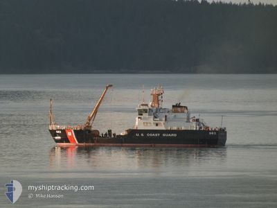
CG
Search and Rescue vessel
Current Trip
| Time Travelled | 1 day |
|---|---|
| Remaining Time | --- |
| Distance Travelled | 240.95 nm |
| Remaining Distance | --- |
| AVG Speed | 7.5 Knopen |
| MAX Speed | 13.6 Knopen |
| AVG Wind | 9.2 knots |
| MAX Wind | 17.3 knots |
| MIN Temp | 8.5°C / 47.3°F |
| MAX Temp | 14.4°C / 57.92°F |
| Diepgang | 3.7 M |
| Positie ontvangen | 1 m geleden |
Current Position
| Lengtegraad | -124.07622° |
|---|---|
| Breedtegraat | 46.92484° |
| Status | Under way using engine |
| Snelheid | 0.5 Knopen |
| Koers | 26° |
| Gebied | North Pacific Ocean |
| Station | T-AIS |
| Positie ontvangen | 1 m geleden |
Info
Information
The current position of CG is in North Pacific Ocean with coordinates 46.92484° / -124.07622° as reported on 2024-05-22 09:43 by AIS to our vessel tracker app. The vessel's current speed is 0.5 Knopen
The vessel CG (MMSI: 338922000) is a Search and Rescue vessel It's sailing under the flag of [US] USA.
In this page you can find informations about the vessels current position, last detected port calls, and current voyage information. If the vessels is not in coverage by AIS you will find the latest position.
The current position of CG is detected by our AIS receivers and we are not responsible for the reliability of the data. The last position was recorded while the vessel was in Coverage by the Ais receivers of our vessel tracking app.
The current draught of CG as reported by AIS is 3.7 meters
Weather
| Temperature | 9.2°C / 48.56°F |
|---|---|
| Wind Speed | 14 knots |
| Direction | 301° WNW |
| Pressure | 1014.2 hPa |
| Humidity | 74.7 % |
| Cloud Coverage | 73 % |
Featured Company
Last Port Calls
| Port | Arrival | Departure | Time In Port |
|---|---|---|---|
| 2024-04-29 21:56 | 2024-05-20 15:50 | 20 d | |
| 2024-04-29 15:01 | 2024-04-29 17:28 | 2 h | |
| 2024-04-26 22:11 | 2024-04-27 21:36 | 23 h | |
| 2024-04-04 23:30 | 2024-04-22 16:17 | 17 d | |
| 2024-04-03 18:48 | 2024-04-03 20:18 | 1 h | |
| 2024-03-29 15:51 | 2024-04-01 16:38 | 3 d | |
| 2024-03-18 15:49 | 2024-03-29 15:37 | 10 d | |
| 2024-03-15 16:59 | 2024-03-18 15:45 | 2 d | |
| 2024-03-08 17:13 | 2024-03-12 22:19 | 4 d | |
| 2024-03-08 17:09 |
Most Visited Ports (Last year)
| Port | Arrivals | |
|---|---|---|
| 30 | ||
| 8 | ||
| 4 | ||
| 2 | ||
| 1 | ||
| 1 |
Last Trips
| Origin | Departure | Destination | Arrival | Distance | |
|---|---|---|---|---|---|
| 2024-04-29 10:28 | 2024-04-29 14:56 | 40.42 nm | |||
| 2024-04-27 14:36 | 2024-04-29 08:01 | 90.75 nm | |||
| 2024-04-22 09:17 | 2024-04-26 15:11 | 239.39 nm | |||
| 2024-04-03 13:18 | 2024-04-04 16:30 | 82.77 nm | |||
| 2024-04-01 09:38 | 2024-04-03 11:48 | 122.38 nm | |||
| 2024-03-29 08:37 | 2024-03-29 08:51 | 1.02 nm | |||
| 2024-03-18 08:45 | 2024-03-18 08:49 | 0.31 nm | |||
| 2024-03-12 15:19 | 2024-03-15 09:59 | 162.95 nm | |||
| 2024-03-08 09:09 | 2024-03-08 09:13 | 0.40 nm |
Events
| Tijd | Evenement | Details | Positie / Bestemming | Info |
|---|---|---|---|---|
| 2024-05-22 02:39 | Stop beweging | 1.7 nm, North East of WESTPORT |
46.92533 / -124.07400
GRAYS HARBOR
|
Snelheid: 0.3 kn Koers: 257° |
| 2024-05-22 02:33 | Start beweging | 1.5 nm, North East of WESTPORT |
46.92296 / -124.07748
GRAYS HARBOR
|
Snelheid: 5.4 kn Koers: 32.7° |
| 2024-05-22 02:30 | Stop beweging | 1.38 nm, North East of WESTPORT |
46.92179 / -124.07985
GRAYS HARBOR
|
Snelheid: 0.1 kn Koers: 322° |
| 2024-05-22 02:30 | Status Changed | Under way using engine Restricted manoeuverability |
46.92181 / -124.07982
GRAYS HARBOR
|
Snelheid: 1.4 kn Koers: 281° |
| 2024-05-22 02:13 | Start beweging | 2.62 nm, East of WESTPORT |
46.92287 / -124.04677
GRAYS HARBOR
|
Snelheid: 3.8 kn Koers: 263° |
| 2024-05-22 00:13 | Stop beweging | 2.51 nm, East of WESTPORT |
46.92178 / -124.04915
GRAYS HARBOR
|
Snelheid: 0.3 kn Koers: 80° |
| 2024-05-22 00:04 | Start beweging | 1.73 nm, North East of WESTPORT |
46.92030 / -124.06871
GRAYS HARBOR
|
Snelheid: 5.5 kn Koers: 81.1° |
| 2024-05-21 22:13 | Status Changed | Restricted manoeuverability Under way using engine |
46.92011 / -124.07157
GRAYS HARBOR
|
Snelheid: 0.3 kn Koers: 114° |
| 2024-05-21 22:08 | Stop beweging | 1.65 nm, North East of WESTPORT |
46.92088 / -124.07132
GRAYS HARBOR
|
Snelheid: 0.2 kn Koers: 136° |
| 2024-05-21 21:53 | Status Changed | Under way using engine Restricted manoeuverability |
46.92401 / -124.09629
GRAYS HARBOR
|
Snelheid: 4.2 kn Koers: 154° |