
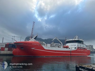
CASPIAN
Cargo
Current Trip
| Trip Time | 4 days |
|---|---|
| Trip Distance | 577.29 nm |
| AVG Speed | 8.7 Knopen |
| MAX Speed | 12.5 Knopen |
| Diepgang | 7.4 M |
| AVG Wind | 9.8 knots |
| MAX Wind | 39.3 knots |
| MIN Temp | -13.3°C / 8.06°F |
| MAX Temp | 6.8°C / 44.24°F |
| Positie ontvangen | 3 m geleden |
Current Position
| Lengtegraad | --- |
|---|---|
| Breedtegraat | --- |
| Status | Moored |
| Snelheid | |
| Koers | 217° |
| Gebied | Norwegian Sea |
| Station | T-AIS |
| Positie ontvangen | 3 m geleden |
Info
Information
The current position of CASPIAN is in Norwegian Sea with coordinates 68.79934° / 16.54982° as reported on 2025-12-05 11:27 by AIS to our vessel tracker app. The vessel's current speed is 0 Knopen and is currently inside the port of HARSTAD.
The vessel CASPIAN (IMO: 9939773, MMSI: 257735000) is a Cargo It's sailing under the flag of [NO] Norway.
In this page you can find informations about the vessels current position, last detected port calls, and current voyage information. If the vessels is not in coverage by AIS you will find the latest position.
The current position of CASPIAN is detected by our AIS receivers and we are not responsible for the reliability of the data. The last position was recorded while the vessel was in Coverage by the Ais receivers of our vessel tracking app.
The current draught of CASPIAN as reported by AIS is 7.4 meters
Weather
| Temperature | 1.9°C / 35.42°F |
|---|---|
| Wind Speed | 3 knots |
| Direction | 159° SSE |
| Pressure | 1017.1 hPa |
| Humidity | 96.2 % |
| Cloud Coverage | 100 % |
Featured Company
Last Port Calls
| Port | Arrival | Departure | Time In Port |
|---|---|---|---|
| 2025-12-04 23:11 | |||
| 2025-11-29 17:26 | 2025-11-30 06:58 | 13 h | |
| 2025-11-26 18:16 | 2025-11-28 03:06 | 1 d | |
| 2025-11-20 19:32 | 2025-11-20 19:53 | 20 m | |
| 2025-11-12 16:10 | 2025-11-12 16:28 | 18 m | |
| 2025-11-07 22:19 | 2025-11-12 15:15 | 4 d | |
| 2025-11-05 12:33 | 2025-11-05 12:55 | 21 m | |
| 2025-11-01 20:59 | 2025-11-05 08:27 | 3 d | |
| 2025-10-27 10:58 | 2025-10-27 15:35 | 4 h | |
| 2025-10-21 19:17 | 2025-10-21 20:18 | 1 h |
Last Trips
| Origin | Departure | Destination | Arrival | Distance | |
|---|---|---|---|---|---|
| 2025-11-30 06:58 | 2025-12-04 23:11 | 577.29 nm | |||
| 2025-11-28 03:06 | 2025-11-29 17:26 | 60.36 nm | |||
| 2025-11-20 19:53 | 2025-11-26 18:16 | 308.21 nm | |||
| 2025-11-12 16:28 | 2025-11-20 19:32 | 542.43 nm | |||
| 2025-11-12 15:15 | 2025-11-12 16:10 | 8.80 nm | |||
| 2025-11-05 12:55 | 2025-11-07 22:19 | 349.53 nm | |||
| 2025-11-05 08:27 | 2025-11-05 12:33 | 29.01 nm | |||
| 2025-10-27 15:35 | 2025-11-01 20:59 | 248.51 nm | |||
| 2025-10-21 20:18 | 2025-10-27 10:58 | 239.19 nm | |||
| 2025-10-21 16:36 | 2025-10-21 19:17 | 25.91 nm |
Events
| Tijd | Evenement | Details | Positie / Bestemming | Info |
|---|---|---|---|---|
| 2025-12-05 08:51 | ETA Changed | 2026/11/30 23:45 2025/12/04 22:00 |
68.79798 / 16.54678
[NO] HARSTAD
|
Snelheid: Koers: 218° |
| 2025-12-05 08:51 | Status Changed | Moored Under way using engine |
68.79798 / 16.54678
[NO] HARSTAD
|
Snelheid: Koers: 218° |
| 2025-12-04 22:28 | Stop beweging |
68.79799 / 16.54681
[NO] HARSTAD
|
Snelheid: 0.2 kn Koers: 216° |
|
| 2025-12-04 22:11 | Aankomsthaven |
|
68.80291 / 16.56168
[NO] HARSTAD
|
Snelheid: 3.3 kn Koers: 218° |
| 2025-12-04 21:35 | Start beweging | 3.36 nm, North East of HARSTAD |
68.84337 / 16.62821
HARSTAD
|
Snelheid: 3.5 kn Koers: 212° |
| 2025-12-04 21:15 | Stop beweging | 3.49 nm, North East of HARSTAD |
68.84574 / 16.62855
HARSTAD
|
Snelheid: 0.3 kn Koers: 108° |
| 2025-12-04 20:44 | Start beweging | 3.45 nm, North of HARSTAD |
68.84801 / 16.61141
HARSTAD
|
Snelheid: 3.3 kn Koers: 62° |
| 2025-12-04 20:17 | Stop beweging | 3.33 nm, North of HARSTAD |
68.84742 / 16.60091
HARSTAD
|
Snelheid: Koers: 342° |
| 2025-12-04 16:27 | Start beweging | 5.02 nm, East of MYRE |
68.90278 / 15.29865
HARSTAD
|
Snelheid: 3.5 kn Koers: 254° |
| 2025-12-04 12:30 | Destination Changed | HARSTAD ALSVAAG |
68.90262 / 15.28784
HARSTAD
|
Snelheid: Koers: 241° |