
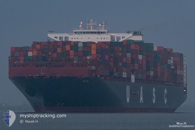
BRUSSELS EXPRESS
Not available
Current Trip
NLRTM-SGSIN
| Time Travelled | 45 days |
|---|---|
| Remaining Time | --- |
| Distance Travelled | 11999.62 nm |
| Remaining Distance | --- |
| AVG Speed | 14 Knopen |
| MAX Speed | 19.4 Knopen |
| AVG Wind | 11.6 knots |
| MAX Wind | 36 knots |
| MIN Temp | 8.5°C / 47.3°F |
| MAX Temp | 31.5°C / 88.7°F |
| Diepgang | 12.3 M |
| Positie ontvangen | 3 m geleden |
Current Position
| Lengtegraad | 104.04808° |
|---|---|
| Breedtegraat | 1.29457° |
| Status | At anchor |
| Snelheid | |
| Koers | 270° |
| Gebied | Singapore Strait |
| Station | T-AIS |
| Positie ontvangen | 3 m geleden |
Info
Information
The current position of BRUSSELS EXPRESS is in Singapore Strait with coordinates 1.29457° / 104.04808° as reported on 2024-05-23 17:21 by AIS to our vessel tracker app. The vessel's current speed is 0 Knopen
The vessel BRUSSELS EXPRESS (IMO: 9708784, MMSI: 211108000) is a Not available It's sailing under the flag of [DE] Germany.
In this page you can find informations about the vessels current position, last detected port calls, and current voyage information. If the vessels is not in coverage by AIS you will find the latest position.
The current position of BRUSSELS EXPRESS is detected by our AIS receivers and we are not responsible for the reliability of the data. The last position was recorded while the vessel was in Coverage by the Ais receivers of our vessel tracking app.
The current draught of BRUSSELS EXPRESS as reported by AIS is 12.3 meters
Weather
| Temperature | 28.1°C / 82.58°F |
|---|---|
| Wind Speed | 4 knots |
| Direction | 224° SW |
| Pressure | 1008.5 hPa |
| Humidity | 81.1 % |
| Cloud Coverage | 100 % |
Featured Company
Last Port Calls
| Port | Arrival | Departure | Time In Port |
|---|---|---|---|
| 2024-04-05 23:32 | 2024-04-08 12:47 | 2 d | |
| 2024-04-03 20:01 | 2024-04-04 19:49 | 23 h | |
| 2024-04-01 11:17 | 2024-04-02 16:40 | 1 d | |
| 2024-03-26 21:49 | 2024-03-29 18:08 | 2 d |
Most Visited Ports (Last year)
| Port | Arrivals | |
|---|---|---|
| 6 | ||
| 6 | ||
| 4 | ||
| 4 | ||
| 3 | ||
| 3 |
Last Trips
| Origin | Departure | Destination | Arrival | Distance | |
|---|---|---|---|---|---|
| 2024-04-04 21:49 | 2024-04-06 01:32 | 284.82 nm | |||
| 2024-04-02 18:40 | 2024-04-03 22:01 | 502.22 nm | |||
| 2024-03-29 18:08 | 2024-04-01 13:17 | 119.78 nm | |||
| 2024-02-22 13:28 | 2024-03-26 21:49 | 11972.89 nm |
Events
| Tijd | Evenement | Details | Positie / Bestemming | Info |
|---|---|---|---|---|
| 2024-05-23 15:44 | Status Changed | At anchor Default |
1.29359 / 104.04748
NLRTM-SGSIN
|
Snelheid: Koers: 278° |
| 2024-05-23 15:40 | Status Changed | Default At anchor |
1.29352 / 104.04747
NLRTM-SGSIN
|
Snelheid: 0.1 kn Koers: 282° |
| 2024-05-23 15:16 | Status Changed | At anchor Default |
1.29294 / 104.04707
NLRTM-SGSIN
|
Snelheid: 0.1 kn Koers: 326° |
| 2024-05-23 15:09 | Status Changed | Default At anchor |
1.29266 / 104.04676
NLRTM-SGSIN
|
Snelheid: 0.1 kn Koers: 326° |
| 2024-05-23 11:07 | Status Changed | At anchor Default |
1.29347 / 104.04440
NLRTM-SGSIN
|
Snelheid: 0.1 kn Koers: 67° |
| 2024-05-23 11:04 | Status Changed | Default At anchor |
1.29354 / 104.04431
NLRTM-SGSIN
|
Snelheid: Koers: 66° |
| 2024-05-23 09:43 | Status Changed | At anchor Default |
1.29426 / 104.04522
NLRTM-SGSIN
|
Snelheid: 0.1 kn Koers: 72° |
| 2024-05-23 09:40 | Status Changed | Default At anchor |
1.29418 / 104.04527
NLRTM-SGSIN
|
Snelheid: Koers: 75° |
| 2024-05-23 06:43 | Status Changed | At anchor Default |
1.29414 / 104.04555
NLRTM-SGSIN
|
Snelheid: Koers: 90° |
| 2024-05-23 06:40 | Status Changed | Default At anchor |
1.29414 / 104.04557
NLRTM-SGSIN
|
Snelheid: Koers: 91° |