
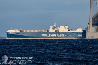
BOTNIA ENABLER
Cargo A
Current Trip
| Time Travelled | 4 h, 16 mins |
|---|---|
| Remaining Time | --- |
| Distance Travelled | 39.77 nm |
| Remaining Distance | --- |
| AVG Speed | 14.3 Knopen |
| MAX Speed | 16 Knopen |
| AVG Wind | 5.5 knots |
| MAX Wind | 7 knots |
| MIN Temp | --- |
| MAX Temp | 1°C / 33.8°F |
| Diepgang | 7.1 M |
| Positie ontvangen | 1 d geleden |
Current Position
| Lengtegraad | --- |
|---|---|
| Breedtegraat | --- |
| Status | Under way using engine |
| Snelheid | 14.1 Knopen |
| Koers | 52.4° |
| Gebied | Gulf of Bothnia |
| Station | T-AIS |
| Positie ontvangen | 1 d geleden |
Info
Information
The current position of BOTNIA ENABLER is in Gulf of Bothnia with coordinates 65.40262° / 24.11056° as reported on 2025-12-04 07:49 by AIS to our vessel tracker app. The vessel's current speed is 14.1 Knopen and is heading at the port of KEMI. The estimated time of arrival as calculated by MyShipTracking vessel tracking app is 2025-12-04 11:00 LT
The vessel BOTNIA ENABLER (IMO: 9884679, MMSI: 265022000) is a Cargo A It's sailing under the flag of [SE] Sweden.
In this page you can find informations about the vessels current position, last detected port calls, and current voyage information. If the vessels is not in coverage by AIS you will find the latest position.
The current position of BOTNIA ENABLER is detected by our AIS receivers and we are not responsible for the reliability of the data. The last position was recorded while the vessel was in Coverage by the Ais receivers of our vessel tracking app.
The current draught of BOTNIA ENABLER as reported by AIS is 7.1 meters
Weather
| Temperature | 0.2°C / 32.36°F |
|---|---|
| Wind Speed | 7 knots |
| Direction | 329° NNW |
| Pressure | 1022.2 hPa |
| Humidity | 86.2 % |
| Cloud Coverage | 100 % |
Featured Company
Last Port Calls
| Port | Arrival | Departure | Time In Port |
|---|---|---|---|
| 2025-12-05 03:55 | 2025-12-05 18:07 | 14 h | |
| 2025-12-04 11:17 | 2025-12-04 23:37 | 12 h | |
| 2025-12-03 20:47 | 2025-12-04 02:38 | 5 h | |
| 2025-12-03 07:17 | 2025-12-03 12:29 | 5 h | |
| 2025-11-28 05:07 | 2025-11-30 00:47 | 1 d | |
| 2025-11-27 17:02 | 2025-11-28 01:39 | 8 h | |
| 2025-11-24 06:49 | 2025-11-24 17:57 | 11 h | |
| 2025-11-22 06:36 | 2025-11-22 13:24 | 6 h | |
| 2025-11-21 01:34 | 2025-11-21 22:37 | 21 h | |
| 2025-11-20 11:36 | 2025-11-20 21:29 | 9 h |
Most Visited Ports (Last year)
| Port | Arrivals | |
|---|---|---|
| 45 | ||
| 25 | ||
| 24 | ||
| 24 | ||
| 24 | ||
| 22 |
Last Trips
| Origin | Departure | Destination | Arrival | Distance | |
|---|---|---|---|---|---|
| 2025-12-04 23:37 | 2025-12-05 03:55 | 51.04 nm | |||
| 2025-12-04 02:38 | 2025-12-04 11:17 | 120.04 nm | |||
| 2025-12-03 12:29 | 2025-12-03 20:47 | 121.94 nm | |||
| 2025-11-30 00:47 | 2025-12-03 07:17 | 1339.39 nm | |||
| 2025-11-28 01:39 | 2025-11-28 05:07 | 52.76 nm | |||
| 2025-11-24 17:57 | 2025-11-27 17:02 | 841.47 nm | |||
| 2025-11-22 13:24 | 2025-11-24 06:49 | 788.68 nm | |||
| 2025-11-21 22:37 | 2025-11-22 06:36 | 134.38 nm | |||
| 2025-11-20 21:29 | 2025-11-21 01:34 | 50.83 nm | |||
| 2025-11-19 19:21 | 2025-11-20 11:36 | 119.86 nm |
Events
| Tijd | Evenement | Details | Positie / Bestemming | Info |
|---|---|---|---|---|
| 2025-12-05 16:21 | Start beweging | 3.72 nm, West of OULU |
65.02950 / 25.30678
FIKEM
|
Snelheid: 14.3 kn Koers: 304° |
| 2025-12-05 16:07 | Vertrekhaven |
|
65.02950 / 25.30678
FIKEM
|
Snelheid: 0.6 kn Koers: 319° |
| 2025-12-05 01:55 | Stop beweging |
64.99774 / 25.41518
[FI] OULU
|
Snelheid: Koers: 318° |
|
| 2025-12-05 01:55 | Aankomsthaven |
|
64.99774 / 25.41518
[FI] OULU
|
Snelheid: 0.8 kn Koers: 322° |
| 2025-12-04 21:37 | Vertrekhaven |
|
65.64868 / 24.50437
FIKEM
|
Snelheid: 6.1 kn Koers: 196° |
| 2025-12-04 21:29 | Start beweging |
65.66190 / 24.51314
[FI] AJOS
|
Snelheid: 3.3 kn Koers: 202° |
|
| 2025-12-04 09:37 | Stop beweging |
65.66473 / 24.51725
[FI] AJOS
|
Snelheid: 0.3 kn Koers: 231° |
|
| 2025-12-04 09:17 | Aankomsthaven |
|
65.65899 / 24.51130
[FI] AJOS
|
Snelheid: 5.2 kn Koers: 12° |
| 2025-12-04 07:57 | Status Changed | Default Under way using engine |
65.42326 / 24.17526
FIKEM
|
Snelheid: 14.1 kn Koers: 52.4° |
| 2025-12-04 07:49 | Buitenbereik |
65.40262 / 24.11056
Gulf of Bothnia
FIKEM
|
Snelheid: 14.1 kn Koers: 52.4° |