
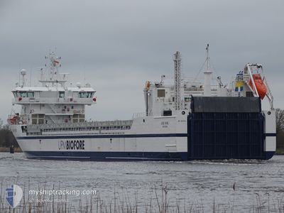
BORE WIND
Cargo
Current Trip
NLVLS VIA KIEL
| Time Travelled | 20 h, 53 mins |
|---|---|
| Remaining Time | --- |
| Distance Travelled | 196.94 nm |
| Remaining Distance | --- |
| AVG Speed | 9.4 Knopen |
| MAX Speed | 19.3 Knopen |
| AVG Wind | 14.7 knots |
| MAX Wind | 19 knots |
| MIN Temp | 12.7°C / 54.86°F |
| MAX Temp | 21.5°C / 70.7°F |
| Diepgang | 5.6 M |
| Positie ontvangen | 1 m geleden |
Current Position
| Lengtegraad | 7.54276° |
|---|---|
| Breedtegraat | 53.99320° |
| Status | Under way using engine |
| Snelheid | 9.9 Knopen |
| Koers | 254.1° |
| Gebied | North Sea |
| Station | T-AIS |
| Positie ontvangen | 1 m geleden |
Info
Information
The current position of BORE WIND is in North Sea with coordinates 53.99320° / 7.54276° as reported on 2024-05-16 02:25 by AIS to our vessel tracker app. The vessel's current speed is 9.9 Knopen
The vessel BORE WIND (IMO: 9892901, MMSI: 246000000) is a Cargo It's sailing under the flag of [NL] Netherlands.
In this page you can find informations about the vessels current position, last detected port calls, and current voyage information. If the vessels is not in coverage by AIS you will find the latest position.
The current position of BORE WIND is detected by our AIS receivers and we are not responsible for the reliability of the data. The last position was recorded while the vessel was in Coverage by the Ais receivers of our vessel tracking app.
The current draught of BORE WIND as reported by AIS is 5.6 meters
Weather
| Temperature | 14.5°C / 58.1°F |
|---|---|
| Wind Speed | 19 knots |
| Direction | 96° E |
| Pressure | 1007.8 hPa |
| Humidity | 79.3 % |
| Cloud Coverage | 1 % |
Featured Company
Last Port Calls
| Port | Arrival | Departure | Time In Port |
|---|---|---|---|
| 2024-05-13 14:21 | 2024-05-15 05:33 | 1 d | |
| 2024-05-09 21:56 | 2024-05-11 13:02 | 1 d | |
| 2024-05-06 14:14 | 2024-05-08 01:19 | 1 d | |
| 2024-05-03 03:43 | 2024-05-04 13:07 | 1 d | |
| 2024-04-29 16:58 | 2024-05-01 05:18 | 1 d | |
| 2024-04-26 03:25 | 2024-04-27 15:56 | 1 d | |
| 2024-04-22 14:19 | 2024-04-24 01:19 | 1 d | |
| 2024-04-19 03:30 | 2024-04-20 09:07 | 1 d | |
| 2024-04-14 20:21 | 2024-04-16 00:10 | 1 d | |
| 2024-03-15 13:07 | 2024-04-10 20:34 | 26 d |
Most Visited Ports (Last year)
| Port | Arrivals | |
|---|---|---|
| 45 | ||
| 45 | ||
| 2 | ||
| 1 | ||
| 1 | ||
| 1 |
Last Trips
| Origin | Departure | Destination | Arrival | Distance | |
|---|---|---|---|---|---|
| 2024-05-11 16:02 | 2024-05-13 16:21 | 589.05 nm | |||
| 2024-05-08 03:19 | 2024-05-10 00:56 | 592.30 nm | |||
| 2024-05-04 16:07 | 2024-05-06 16:14 | 589.92 nm | |||
| 2024-05-01 07:18 | 2024-05-03 06:43 | 592.03 nm | |||
| 2024-04-27 18:56 | 2024-04-29 18:58 | 589.81 nm | |||
| 2024-04-24 03:19 | 2024-04-26 06:25 | 592.31 nm | |||
| 2024-04-20 12:07 | 2024-04-22 16:19 | 590.52 nm | |||
| 2024-04-16 02:10 | 2024-04-19 06:30 | 956.40 nm | |||
| 2024-04-10 23:34 | 2024-04-14 22:21 | 1200.36 nm | |||
| 2024-03-13 03:55 | 2024-03-15 15:07 | 636.77 nm |
Events
| Tijd | Evenement | Details | Positie / Bestemming | Info |
|---|---|---|---|---|
| 2024-05-15 21:51 | Start beweging | 0.86 nm, South West of BRUNSBUETTEL |
53.89252 / 9.14321
NLVLS VIA KIEL
|
Snelheid: 4.3 kn Koers: 229° |
| 2024-05-15 21:50 | Wijzig zee gebeid | German part of the North Sea German part of the Baltic Sea |
53.89314 / 9.14443
North Sea
NLVLS VIA KIEL
|
Snelheid: 2.8 kn Koers: 230.3° |
| 2024-05-15 21:25 | Stop beweging | 0.76 nm, South West of BRUNSBUETTEL |
53.89371 / 9.14551
NLVLS VIA KIEL
|
Snelheid: 0.3 kn Koers: 229° |
| 2024-05-15 19:03 | Status Changed | Under way using engine Default |
54.10326 / 9.32945
NLVLS VIA KIEL
|
Snelheid: 7 kn Koers: 175° |
| 2024-05-15 18:58 | Status Changed | Default Under way using engine |
54.11339 / 9.32843
NLVLS VIA KIEL
|
Snelheid: 7 kn Koers: 184.5° |
| 2024-05-15 14:34 | Start beweging | 7.11 nm, West of KIEL |
54.34234 / 9.95802
NLVLS VIA KIEL
|
Snelheid: 3.3 kn Koers: 261° |
| 2024-05-15 14:19 | Stop beweging | 6.98 nm, West of KIEL |
54.34265 / 9.96170
NLVLS VIA KIEL
|
Snelheid: 0.3 kn Koers: 260° |
| 2024-05-15 13:10 | Start beweging | 1.41 nm, South West of STICKENHΟRN SPORT |
54.36659 / 10.13893
NLVLS VIA KIEL
|
Snelheid: 3.9 kn Koers: 286° |
| 2024-05-15 12:25 | Stop beweging | 1.36 nm, South West of STICKENHΟRN SPORT |
54.36606 / 10.14208
NLVLS VIA KIEL
|
Snelheid: 0.3 kn Koers: 285° |
| 2024-05-15 10:35 | Wijzig zee gebeid | German part of the Baltic Sea Danish part of the Baltic Sea |
54.56588 / 10.56549
Baltic Sea
NLVLS VIA KIEL
|
Snelheid: 15.9 kn Koers: 246.8° |