
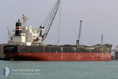
BELLEMAR
Bulk Carrier
Current Trip
| Time Travelled | 4 days |
|---|---|
| Remaining Time | --- |
| Distance Travelled | 495.05 nm |
| Remaining Distance | --- |
| AVG Speed | 11.1 Knopen |
| MAX Speed | 11.8 Knopen |
| AVG Wind | 9.2 knots |
| MAX Wind | 17.8 knots |
| MIN Temp | 11.5°C / 52.7°F |
| MAX Temp | 14.8°C / 58.64°F |
| Diepgang | 9.9 M |
| Positie ontvangen | 2 d geleden |
Current Position
| Lengtegraad | -57.72451° |
|---|---|
| Breedtegraat | -38.84013° |
| Status | Under way using engine |
| Snelheid | 11.2 Knopen |
| Koers | 251.5° |
| Gebied | South Atlantic Ocean |
| Station | T-AIS |
| Positie ontvangen | 2 d geleden |
Info
Information
The current position of BELLEMAR is in South Atlantic Ocean with coordinates -38.84013° / -57.72451° as reported on 2024-06-07 09:05 by AIS to our vessel tracker app. The vessel's current speed is 11.2 Knopen
The vessel BELLEMAR (IMO: 9376385, MMSI: 209411000) is a Bulk Carrier that was built in 2007 ( 17 Jaar oud ). It's sailing under the flag of [CY] Cyprus.
In this page you can find informations about the vessels current position, last detected port calls, and current voyage information. If the vessels is not in coverage by AIS you will find the latest position.
The current position of BELLEMAR is detected by our AIS receivers and we are not responsible for the reliability of the data. The last position was recorded while the vessel was in Coverage by the Ais receivers of our vessel tracking app.
The current draught of BELLEMAR as reported by AIS is 9.9 meters
Weather
| Temperature | 11.5°C / 52.7°F |
|---|---|
| Wind Speed | 10 knots |
| Direction | 263° W |
| Pressure | 1011.9 hPa |
| Humidity | 74.9 % |
| Cloud Coverage | 85 % |
Featured Company
Last Port Calls
| Port | Arrival | Departure | Time In Port |
|---|---|---|---|
| 2024-06-02 09:19 | 2024-06-06 02:18 | 3 d | |
| 2024-04-16 14:03 |
Most Visited Ports (Last year)
| Port | Arrivals | |
|---|---|---|
| 1 | ||
| 1 | ||
| 1 | ||
| 1 | ||
| 1 | ||
| 1 |
Last Trips
| Origin | Departure | Destination | Arrival | Distance | |
|---|---|---|---|---|---|
| 2024-04-16 14:03 | 2024-06-02 09:19 | 7157.67 nm |
Events
| Tijd | Evenement | Details | Positie / Bestemming | Info |
|---|---|---|---|---|
| 2024-06-08 02:10 | Stop beweging |
-39.29426 / -61.58791
BAHIA BLANCA
|
Snelheid: 0.1 kn Koers: 343° |
|
| 2024-06-07 09:13 | Status Changed | Default Under way using engine |
-38.84667 / -57.75167
BAHIA BLANCA
|
Snelheid: 11.2 kn Koers: 251.5° |
| 2024-06-07 09:05 | Status Changed | Under way using engine Default |
-38.84013 / -57.72451
BAHIA BLANCA
|
Snelheid: 11 kn Koers: 254° |
| 2024-06-07 09:05 | Buitenbereik |
-38.84013 / -57.72451
South Atlantic Ocean
BAHIA BLANCA
|
Snelheid: 11.2 kn Koers: 251.5° |
|
| 2024-06-07 08:49 | Binnenbereik |
-38.84013 / -57.72451
South Atlantic Ocean
BAHIA BLANCA
|
Snelheid: 11.2 kn Koers: 251.5° |
|
| 2024-06-07 07:45 | Status Changed | Default Under way using engine |
-38.67542 / -57.47911
BAHIA BLANCA
|
Snelheid: 11.5 kn Koers: 227.7° |
| 2024-06-07 07:39 | Buitenbereik |
-38.66232 / -57.46092
South Atlantic Ocean
BAHIA BLANCA
|
Snelheid: 11.5 kn Koers: 227.7° |
|
| 2024-06-06 23:52 | Binnenbereik |
-37.47290 / -56.33189
South Atlantic Ocean
BAHIA BLANCA
|
Snelheid: 11.6 kn Koers: 209.9° |
|
| 2024-06-06 22:24 | Buitenbereik |
-37.22400 / -56.15068
South Atlantic Ocean
BAHIA BLANCA
|
Snelheid: 11.8 kn Koers: 208.6° |
|
| 2024-06-06 20:11 | ETA Changed | 2024/06/08 04:00 2024/06/08 02:30 |
-36.84544 / -55.87271
BAHIA BLANCA
|
Snelheid: 11.8 kn Koers: 210° |