
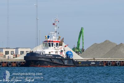
ATLANTIS
Towing
Current Trip
| Time Travelled | 1 day |
|---|---|
| Remaining Time | 7 days |
| Distance Travelled | 192.78 nm |
| Remaining Distance | 575.28 nm |
| AVG Speed | 5.4 Knopen |
| MAX Speed | 7.6 Knopen |
| AVG Wind | 7.9 knots |
| MAX Wind | 15.8 knots |
| MIN Temp | 6.3°C / 43.34°F |
| MAX Temp | 10.2°C / 50.36°F |
| Diepgang | 5.2 M |
| Positie ontvangen | 1 m geleden |
Current Position
| Lengtegraad | -5.59117° |
|---|---|
| Breedtegraat | 53.06772° |
| Status | Towing Astern |
| Snelheid | 3.8 Knopen |
| Koers | 187° |
| Gebied | Irish Sea and St. George's Channel |
| Station | T-AIS |
| Positie ontvangen | 1 m geleden |
Info
Information
The current position of ATLANTIS is in Irish Sea and St. George's Channel with coordinates 53.06772° / -5.59117° as reported on 2024-04-29 01:05 by AIS to our vessel tracker app. The vessel's current speed is 3.8 Knopen and is heading at the port of VLISSINGEN. The estimated time of arrival as calculated by MyShipTracking vessel tracking app is 2024-05-06 18:43 LT
The vessel ATLANTIS (IMO: 9660932, MMSI: 244850974) is a Towing It's sailing under the flag of [NL] Netherlands.
In this page you can find informations about the vessels current position, last detected port calls, and current voyage information. If the vessels is not in coverage by AIS you will find the latest position.
The current position of ATLANTIS is detected by our AIS receivers and we are not responsible for the reliability of the data. The last position was recorded while the vessel was in Coverage by the Ais receivers of our vessel tracking app.
The current draught of ATLANTIS as reported by AIS is 5.2 meters
Weather
| Temperature | 9.4°C / 48.92°F |
|---|---|
| Wind Speed | 13 knots |
| Direction | 214° SW |
| Pressure | 1006.3 hPa |
| Humidity | 87.2 % |
| Cloud Coverage | 100 % |
Featured Company
Last Port Calls
| Port | Arrival | Departure | Time In Port |
|---|---|---|---|
| 2024-04-24 10:22 | 2024-04-27 12:46 | 3 d | |
| 2024-04-17 09:58 | 2024-04-17 10:37 | 38 m | |
| 2024-04-16 13:42 | 2024-04-16 13:49 | 7 m | |
| 2024-04-16 12:42 | 2024-04-16 12:56 | 13 m | |
| 2024-04-14 22:05 | 2024-04-16 11:23 | 1 d | |
| 2024-03-25 11:15 | 2024-03-25 23:39 | 12 h | |
| 2024-03-11 17:24 | |||
| 2024-02-12 10:32 | 2024-02-14 11:05 | 2 d | |
| 2024-02-09 09:01 | 2024-02-09 09:08 | 6 m | |
| 2024-02-07 00:11 | 2024-02-09 08:55 | 2 d |
Last Trips
| Origin | Departure | Destination | Arrival | Distance | |
|---|---|---|---|---|---|
| 2024-04-17 12:37 | 2024-04-24 11:22 | 841.00 nm | |||
| 2024-04-16 15:49 | 2024-04-17 11:58 | 5.67 nm | |||
| 2024-04-16 14:56 | 2024-04-16 15:42 | 1.99 nm | |||
| 2024-04-16 13:23 | 2024-04-16 14:42 | 4.34 nm | |||
| 2024-03-25 23:39 | 2024-04-15 00:05 | 3572.42 nm | |||
| 2024-03-11 18:24 | 2024-03-25 11:15 | 1791.94 nm | |||
| 2024-02-09 10:08 | 2024-02-12 11:32 | 320.95 nm | |||
| 2024-02-09 09:55 | 2024-02-09 10:01 | 1.02 nm | |||
| 2024-02-07 01:05 | 2024-02-07 01:11 | 0.47 nm | |||
| 2024-02-06 06:40 | 2024-02-06 06:48 | 0.54 nm |
Events
| Tijd | Evenement | Details | Positie / Bestemming | Info |
|---|---|---|---|---|
| 2024-04-28 20:08 | Wijzig zee gebeid | Irish part of the Irish Sea and St. George's Channel United Kingdom part of the Irish Sea and St. George's Channel |
53.30335 / -5.53182
Irish Sea and St. George's Channel
NLVLI
|
Snelheid: 4.7 kn Koers: 189.6° |
| 2024-04-28 20:08 | Status Changed | Towing Astern Default |
53.30335 / -5.53182
NLVLI
|
Snelheid: 5.3 kn Koers: 188° |
| 2024-04-28 19:52 | Binnenbereik |
53.30335 / -5.53182
Irish Sea and St. George's Channel
NLVLI
|
Snelheid: 4.7 kn Koers: 189.6° |
|
| 2024-04-28 12:38 | Status Changed | Default Towing Astern |
54.04850 / -5.34652
NLVLI
|
Snelheid: 5.8 kn Koers: 188.6° |
| 2024-04-28 12:32 | Buitenbereik |
54.05857 / -5.34412
Irish Sea and St. George's Channel
NLVLI
|
Snelheid: 5.8 kn Koers: 188.6° |
|
| 2024-04-28 12:28 | Status Changed | Towing Astern Default |
54.06529 / -5.34259
NLVLI
|
Snelheid: 5.9 kn Koers: 188° |
| 2024-04-28 12:26 | Status Changed | Default Towing Astern |
54.06775 / -5.34203
NLVLI
|
Snelheid: 5.8 kn Koers: 188.7° |
| 2024-04-28 12:26 | Status Changed | Towing Astern Default |
54.06853 / -5.34185
NLVLI
|
Snelheid: 5.8 kn Koers: 188° |
| 2024-04-28 12:23 | Binnenbereik |
54.06529 / -5.34259
Irish Sea and St. George's Channel
NLVLI
|
Snelheid: 5.9 kn Koers: 187.2° |
|
| 2024-04-28 11:20 | Buitenbereik |
54.17803 / -5.31560
Irish Sea and St. George's Channel
NLVLI
|
Snelheid: 6.1 kn Koers: 188.7° |