
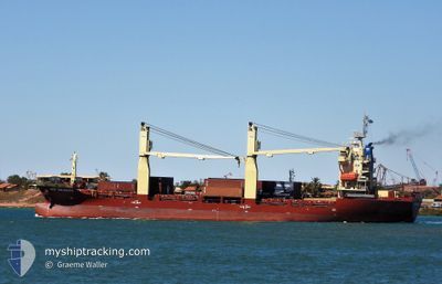
ANL BURRUP TRADER
General Cargo
Current Trip
| Time Travelled | 2 days |
|---|---|
| Remaining Time | --- |
| Distance Travelled | 527.21 nm |
| Remaining Distance | --- |
| AVG Speed | 10.2 Knopen |
| MAX Speed | 12 Knopen |
| AVG Wind | 8.6 knots |
| MAX Wind | 17 knots |
| MIN Temp | 27.4°C / 81.32°F |
| MAX Temp | 28.7°C / 83.66°F |
| Diepgang | 5.7 M |
| Positie ontvangen | 2 d geleden |
Current Position
| Lengtegraad | --- |
|---|---|
| Breedtegraat | --- |
| Status | Under way using engine |
| Snelheid | 9 Knopen |
| Koers | 336.5° |
| Gebied | Indian Ocean |
| Station | T-AIS |
| Positie ontvangen | 2 d geleden |
Info
Information
The current position of ANL BURRUP TRADER is in Indian Ocean with coordinates -20.22964° / 118.56258° as reported on 2025-12-07 22:27 by AIS to our vessel tracker app. The vessel's current speed is 9 Knopen and is heading at the port of SINGAPORE. The estimated time of arrival as calculated by MyShipTracking vessel tracking app is 2025-12-16 12:00 LT
The vessel ANL BURRUP TRADER (IMO: 9383481, MMSI: 212031000) is a General Cargo that was built in 2008 ( 17 Jaar oud ). It's sailing under the flag of [CY] Cyprus.
In this page you can find informations about the vessels current position, last detected port calls, and current voyage information. If the vessels is not in coverage by AIS you will find the latest position.
The current position of ANL BURRUP TRADER is detected by our AIS receivers and we are not responsible for the reliability of the data. The last position was recorded while the vessel was in Coverage by the Ais receivers of our vessel tracking app.
The current draught of ANL BURRUP TRADER as reported by AIS is 5.7 meters
Weather
| Temperature | 28.6°C / 83.48°F |
|---|---|
| Wind Speed | 8 knots |
| Direction | 231° SW |
| Pressure | 1008.4 hPa |
| Humidity | 69 % |
| Cloud Coverage | 95 % |
Featured Company
Last Port Calls
| Port | Arrival | Departure | Time In Port |
|---|---|---|---|
| 2025-12-07 11:48 | 2025-12-07 21:59 | 10 h | |
| 2025-12-04 11:08 | 2025-12-07 00:04 | 2 d | |
| 2025-11-26 13:48 | 2025-11-27 13:59 | 1 d | |
| 2025-11-17 09:59 | 2025-11-18 10:27 | 1 d | |
| 2025-11-14 02:32 | 2025-11-16 09:39 | 2 d | |
| 2025-11-07 02:12 | 2025-11-07 12:36 | 10 h | |
| 2025-11-05 21:56 | 2025-11-06 22:35 | 1 d | |
| 2025-10-29 10:13 | 2025-10-30 10:55 | 1 d | |
| 2025-10-16 15:53 | 2025-10-17 17:11 | 1 d | |
| 2025-10-08 00:16 | 2025-10-08 08:52 | 8 h |
Most Visited Ports (Last year)
| Port | Arrivals | |
|---|---|---|
| 18 | ||
| 17 | ||
| 15 | ||
| 7 | ||
| 1 | ||
| 1 |
Last Trips
| Origin | Departure | Destination | Arrival | Distance | |
|---|---|---|---|---|---|
| 2025-12-07 08:04 | 2025-12-07 19:48 | 140.72 nm | |||
| 2025-11-27 21:59 | 2025-12-04 19:08 | 1701.57 nm | |||
| 2025-11-18 18:27 | 2025-11-26 21:48 | 1781.15 nm | |||
| 2025-11-16 17:39 | 2025-11-17 17:59 | 157.97 nm | |||
| 2025-11-07 19:36 | 2025-11-14 10:32 | 1685.83 nm | |||
| 2025-11-07 06:35 | 2025-11-07 09:12 | 33.06 nm | |||
| 2025-10-30 18:55 | 2025-11-06 05:56 | 1764.39 nm | |||
| 2025-10-18 01:11 | 2025-10-29 18:13 | 2438.10 nm | |||
| 2025-10-08 16:52 | 2025-10-16 23:53 | 1722.59 nm | |||
| 2025-10-06 15:59 | 2025-10-08 08:16 | 254.82 nm |
Events
| Tijd | Evenement | Details | Positie / Bestemming | Info |
|---|---|---|---|---|
| 2025-12-07 22:36 | Status Changed | Default Under way using engine |
-20.20733 / 118.55573
SG PEBGA
|
Snelheid: 9 kn Koers: 336.5° |
| 2025-12-07 22:27 | Buitenbereik |
-20.22964 / 118.56258
Indian Ocean
SG PEBGA
|
Snelheid: 9 kn Koers: 336.5° |
|
| 2025-12-07 21:59 | Vertrekhaven |
|
-20.30346 / 118.57945
SG PEBGA
|
Snelheid: 10.2 kn Koers: 41° |
| 2025-12-07 21:54 | Start beweging |
-20.31290 / 118.57101
[AU] PORT HEDLAND
|
Snelheid: 4.3 kn Koers: 22° |
|
| 2025-12-07 21:38 | Status Changed | Under way using engine Moored |
-20.31441 / 118.57267
[AU] PORT HEDLAND
|
Snelheid: Koers: 167° |
| 2025-12-07 21:33 | Status Changed | Moored Default |
-20.31442 / 118.57264
[AU] PORT HEDLAND
|
Snelheid: Koers: 167° |
| 2025-12-07 21:27 | Status Changed | Default Moored |
-20.31439 / 118.57265
[AU] PORT HEDLAND
|
Snelheid: Koers: 167° |
| 2025-12-07 21:09 | Status Changed | Moored Default |
-20.31443 / 118.57265
[AU] PORT HEDLAND
|
Snelheid: Koers: 167° |
| 2025-12-07 21:06 | Status Changed | Default Moored |
-20.31443 / 118.57264
[AU] PORT HEDLAND
|
Snelheid: Koers: 167° |
| 2025-12-07 19:45 | Status Changed | Moored Default |
-20.31442 / 118.57273
[AU] PORT HEDLAND
|
Snelheid: Koers: 167° |