
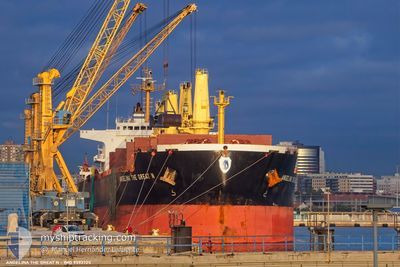
ANGELINA THE GREAT N
Bulk Carrier
Current Trip
| Time Travelled | 6 days |
|---|---|
| Remaining Time | --- |
| Distance Travelled | 1502.13 nm |
| Remaining Distance | --- |
| AVG Speed | 8.8 Knopen |
| MAX Speed | 13.9 Knopen |
| AVG Wind | 8.9 knots |
| MAX Wind | 29.5 knots |
| MIN Temp | 10.9°C / 51.62°F |
| MAX Temp | 18.9°C / 66.02°F |
| Diepgang | 9.5 M |
| Positie ontvangen | 1 d geleden |
Current Position
| Lengtegraad | --- |
|---|---|
| Breedtegraat | --- |
| Status | Under way using engine |
| Snelheid | 11.4 Knopen |
| Koers | 152.1° |
| Gebied | North Atlantic Ocean |
| Station | T-AIS |
| Positie ontvangen | 1 d geleden |
Info
Information
The current position of ANGELINA THE GREAT N is in North Atlantic Ocean with coordinates 18.12848° / -16.33929° as reported on 2025-12-15 06:43 by AIS to our vessel tracker app. The vessel's current speed is 11.4 Knopen
The vessel ANGELINA THE GREAT N (IMO: 9593725, MMSI: 538011862) is a Bulk Carrier that was built in 2012 ( 13 Jaar oud ). It's sailing under the flag of [MH] Marshall Is.
In this page you can find informations about the vessels current position, last detected port calls, and current voyage information. If the vessels is not in coverage by AIS you will find the latest position.
The current position of ANGELINA THE GREAT N is detected by our AIS receivers and we are not responsible for the reliability of the data. The last position was recorded while the vessel was in Coverage by the Ais receivers of our vessel tracking app.
The current draught of ANGELINA THE GREAT N as reported by AIS is 9.5 meters
Weather
| Temperature | 19°C / 66.2°F |
|---|---|
| Wind Speed | 13 knots |
| Direction | 24° NNE |
| Pressure | 1015.8 hPa |
| Humidity | 68.1 % |
| Cloud Coverage | --- |
Featured Company
Most Visited Ports (Last year)
| Port | Arrivals | |
|---|---|---|
| 1 |
Last Trips
| Origin | Departure | Destination | Arrival | Distance |
|---|
Events
| Tijd | Evenement | Details | Positie / Bestemming | Info |
|---|---|---|---|---|
| 2025-12-15 06:43 | Buitenbereik |
18.12848 / -16.33929
North Atlantic Ocean
NOUAKCHOTT
|
Snelheid: 11.4 kn Koers: 152.1° |
|
| 2025-12-15 06:43 | Wijzig zee gebeid | Mauritanian part of the North Atlantic Ocean Moroccan part of the Strait of Gibraltar |
18.12848 / -16.33929
North Atlantic Ocean
NOUAKCHOTT
|
Snelheid: 11.4 kn Koers: 152.1° |
| 2025-12-15 06:43 | Binnenbereik |
18.12848 / -16.33929
North Atlantic Ocean
NOUAKCHOTT
|
Snelheid: 11.4 kn Koers: 152.1° |
|
| 2025-12-11 01:40 | Buitenbereik |
35.92583 / -5.80054
Strait of Gibraltar
NOUAKCHOTT
|
Snelheid: 12.7 kn Koers: 239.6° |
|
| 2025-12-11 01:34 | Gevonden in zee | Moroccan part of the Strait of Gibraltar |
35.93567 / -5.78027
Strait of Gibraltar
NOUAKCHOTT
|
Snelheid: 12.6 kn Koers: 237.2° |
| 2025-12-10 23:35 | Wijzig zee gebeid | Spanish part of the Strait of Gibraltar Gibraltarian part of the Strait of Gibraltar |
36.07242 / -5.37213
Strait of Gibraltar
NOUAKCHOTT
|
Snelheid: 11.4 kn Koers: 179.5° |
| 2025-12-10 23:05 | Start beweging | 1.35 nm, South of GIBRALTAR |
36.12593 / -5.37089
NOUAKCHOTT
|
Snelheid: 3.1 kn Koers: 275° |
| 2025-12-10 22:58 | Status Changed | Under way using engine At anchor |
36.12537 / -5.36608
NOUAKCHOTT
|
Snelheid: 0.3 kn Koers: 289° |
| 2025-12-10 22:55 | Status Changed | At anchor Under way using engine |
36.12533 / -5.36587
NOUAKCHOTT
|
Snelheid: 0.3 kn Koers: 289° |
| 2025-12-10 22:55 | Status Changed | Under way using engine At anchor |
36.12532 / -5.36582
NOUAKCHOTT
|
Snelheid: 0.4 kn Koers: 290° |