
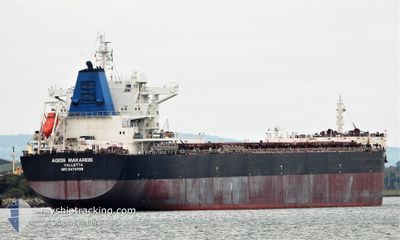
AGIOS MAKARIOS
Cargo
Current Trip
AU HPT
| Time Travelled | 5 days |
|---|---|
| Remaining Time | --- |
| Distance Travelled | 1453.62 nm |
| Remaining Distance | --- |
| AVG Speed | 9.9 Knopen |
| MAX Speed | 15.6 Knopen |
| AVG Wind | 9.3 knots |
| MAX Wind | 17.5 knots |
| MIN Temp | 25.1°C / 77.18°F |
| MAX Temp | 30°C / 86°F |
| Diepgang | 7.1 M |
| Positie ontvangen | 5 d geleden |
Current Position
| Lengtegraad | --- |
|---|---|
| Breedtegraat | --- |
| Status | Under way using engine |
| Snelheid | 9.9 Knopen |
| Koers | 34.4° |
| Gebied | Coral Sea |
| Station | T-AIS |
| Positie ontvangen | 5 d geleden |
Info
Information
The current position of AGIOS MAKARIOS is in Coral Sea with coordinates -20.98068° / 149.65776° as reported on 2025-12-31 07:09 by AIS to our vessel tracker app. The vessel's current speed is 9.9 Knopen
The vessel AGIOS MAKARIOS (IMO: 9474709, MMSI: 215849000) is a Cargo It's sailing under the flag of [MT] Malta.
In this page you can find informations about the vessels current position, last detected port calls, and current voyage information. If the vessels is not in coverage by AIS you will find the latest position.
The current position of AGIOS MAKARIOS is detected by our AIS receivers and we are not responsible for the reliability of the data. The last position was recorded while the vessel was in Coverage by the Ais receivers of our vessel tracking app.
The current draught of AGIOS MAKARIOS as reported by AIS is 7.1 meters
Weather
| Temperature | 29.2°C / 84.56°F |
|---|---|
| Wind Speed | 11 knots |
| Direction | 354° N |
| Pressure | 1007.5 hPa |
| Humidity | 70 % |
| Cloud Coverage | 100 % |
Featured Company
Most Visited Ports (Last year)
| Port | Arrivals | |
|---|---|---|
| 1 | ||
| 1 | ||
| 1 | ||
| 1 | ||
| 1 | ||
| 1 |
Last Trips
| Origin | Departure | Destination | Arrival | Distance | |
|---|---|---|---|---|---|
| 2025-10-18 12:33 | 2025-12-30 05:23 | 11377.33 nm |
Events
| Tijd | Evenement | Details | Positie / Bestemming | Info |
|---|---|---|---|---|
| 2025-12-31 07:16 | Status Changed | Default Under way using engine |
-20.96631 / 149.66806
AU HPT
|
Snelheid: 9.9 kn Koers: 34.4° |
| 2025-12-31 07:09 | Status Changed | Under way using engine Default |
-20.98068 / 149.65776
AU HPT
|
Snelheid: 10 kn Koers: 34° |
| 2025-12-31 07:09 | Buitenbereik |
-20.98068 / 149.65776
Coral Sea
|
Snelheid: 9.9 kn Koers: 34.4° |
|
| 2025-12-31 06:36 | Status Changed | Default Under way using engine |
-21.05852 / 149.60054
AU HPT
|
Snelheid: 10.1 kn Koers: 30.8° |
| 2025-12-31 04:14 | Vertrekhaven |
|
-21.26696 / 149.32037
AU HPT
|
Snelheid: 7 kn Koers: 121° |
| 2025-12-31 04:03 | Start beweging |
-21.25161 / 149.30874
[AU] DALRYMPLE
|
Snelheid: 3.1 kn Koers: 139° |
|
| 2025-12-31 03:35 | Status Changed | Under way using engine Moored |
-21.25031 / 149.30586
[AU] DALRYMPLE
|
Snelheid: 0.1 kn Koers: 149° |
| 2025-12-30 23:49 | Status Changed | Moored Default |
-21.25023 / 149.30582
[AU] DALRYMPLE
|
Snelheid: Koers: 149° |
| 2025-12-30 23:46 | Status Changed | Default Moored |
-21.25023 / 149.30582
[AU] DALRYMPLE
|
Snelheid: Koers: 149° |
| 2025-12-30 21:43 | Status Changed | Moored Default |
-21.25023 / 149.30584
[AU] DALRYMPLE
|
Snelheid: 0.1 kn Koers: 149° |