
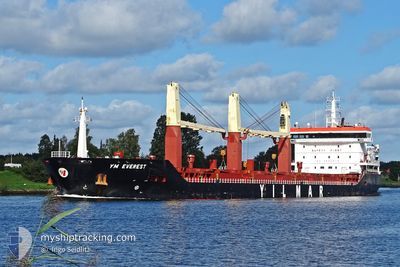
YM EVEREST
General Cargo
Current Trip
| Trip Time | 2 days |
|---|---|
| Trip Distance | 653.58 nm |
| AVG Speed | 11.1 Noeuds |
| MAX Speed | 13 Noeuds |
| Tirant d eau | 5.5 m |
| AVG Wind | 12.4 knots |
| MAX Wind | 27 knots |
| MIN Temp | 8°C / 46.4°F |
| MAX Temp | 21.2°C / 70.16°F |
| Position reçue | 2 d depuis |
Current Position
| Longitude | --- |
|---|---|
| Latitude | --- |
| Etat | Under way using engine |
| Vitesse | 10.7 Noeuds |
| Parcours | 43.9° |
| Zone | Sea of Marmara |
| Station | T-AIS |
| Position reçue | 2 d depuis |
Info
Information
The current position of YM EVEREST is in Sea of Marmara with coordinates 40.31927° / 26.61853° as reported on 2025-12-07 14:01 by AIS to our vessel tracker app. The vessel's current speed is 10.7 Noeuds and is currently inside the port of ICDAS.
The vessel YM EVEREST (IMO: 9653812, MMSI: 229941000) is a General Cargo that was built in 2014 ( 11 Age ). It's sailing under the flag of [MT] Malta.
In this page you can find informations about the vessels current position, last detected port calls, and current voyage information. If the vessels is not in coverage by AIS you will find the latest position.
The current position of YM EVEREST is detected by our AIS receivers and we are not responsible for the reliability of the data. The last position was recorded while the vessel was in Coverage by the Ais receivers of our vessel tracking app.
The current draught of YM EVEREST as reported by AIS is 5.5 meters
Weather
| Temperature | 9.8°C / 49.64°F |
|---|---|
| Wind Speed | 6 knots |
| Direction | 64° ENE |
| Pressure | 1023 hPa |
| Humidity | 75.1 % |
| Cloud Coverage | 99 % |
Featured Company
Last Port Calls
| Port | Arrival | Departure | Time In Port |
|---|---|---|---|
| 2025-12-07 20:00 | |||
| 2025-12-01 12:44 | 2025-12-05 09:09 | 3 d | |
| 2025-11-01 18:20 | 2025-11-11 19:16 | 10 d | |
| 2025-10-27 01:16 | 2025-10-29 20:48 | 2 d | |
| 2025-10-10 07:08 | 2025-10-11 01:36 | 18 h | |
| 2025-10-08 05:13 | 2025-10-09 22:41 | 1 d | |
| 2025-10-01 16:36 | 2025-10-06 06:45 | 4 d |
Most Visited Ports (Last year)
| Port | Arrivals | |
|---|---|---|
| 7 | ||
| 6 | ||
| 2 | ||
| 2 | ||
| 2 | ||
| 1 |
Last Trips
| Origin | Departure | Destination | Arrival | Distance | |
|---|---|---|---|---|---|
| 2025-12-05 09:09 | 2025-12-07 20:00 | 653.58 nm | |||
| 2025-11-11 19:16 | 2025-12-01 12:44 | 4522.52 nm | |||
| 2025-10-29 20:48 | 2025-11-01 18:20 | 773.49 nm | |||
| 2025-10-11 01:36 | 2025-10-27 01:16 | 3956.08 nm | |||
| 2025-10-09 22:41 | 2025-10-10 07:08 | 89.58 nm | |||
| 2025-10-06 06:45 | 2025-10-08 05:13 | 452.47 nm | |||
| 2025-09-10 23:29 | 2025-10-01 16:36 | 4647.10 nm |
Events
| Heure | Evenement | Détails | Position/ Destination | Info |
|---|---|---|---|---|
| 2025-12-07 17:15 | Arret |
40.45264 / 27.14235
[TR] ICDAS
|
Vitesse: Parcours: 166° |
|
| 2025-12-07 17:00 | Port d'arrivée |
|
40.45463 / 27.14082
[TR] ICDAS
|
Vitesse: 4.3 kn Parcours: 138° |
| 2025-12-07 14:06 | Etat Changé | Default Under way using engine |
40.33009 / 26.63210
TRIDS
|
Vitesse: 10.7 kn Parcours: 43.9° |
| 2025-12-07 14:01 | Hors de la zone couverte |
40.31927 / 26.61853
Sea of Marmara
TRIDS
|
Vitesse: 10.7 kn Parcours: 43.9° |
|
| 2025-12-07 11:13 | Changement de zone | Turkish part of the Sea of Marmara Turkish part of the Aegean Sea |
40.01908 / 26.20291
Sea of Marmara
TRIDS
|
Vitesse: 10 kn Parcours: 76.1° |
| 2025-12-07 10:49 | Changement de zone | Turkish part of the Aegean Sea Greek part of the Aegean Sea |
40.00312 / 26.12832
Aegean Sea
TRIDS
|
Vitesse: 10.2 kn Parcours: 72.9° |
| 2025-12-07 10:47 | Etat Changé | Under way using engine Default |
40.00183 / 26.12241
TRIDS
|
Vitesse: 8.3 kn Parcours: 70° |
| 2025-12-07 10:47 | Dans la zone couverte |
40.00312 / 26.12832
Aegean Sea
TRIDS
|
Vitesse: 10.2 kn Parcours: 72.9° |
|
| 2025-12-07 08:44 | Etat Changé | Default Under way using engine |
39.79773 / 25.81840
TRIDS
|
Vitesse: 10.9 kn Parcours: 21° |
| 2025-12-07 08:38 | Hors de la zone couverte |
39.78088 / 25.80991
Aegean Sea
TRIDS
|
Vitesse: 10.9 kn Parcours: 21° |