
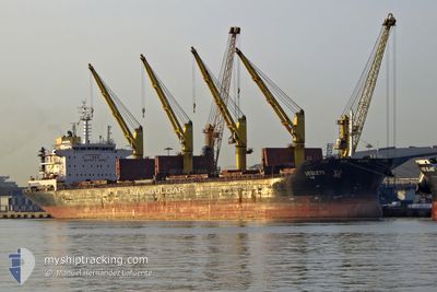
VESLETS
Bulk Carrier
Current Trip
| Time Travelled | 41 days |
|---|---|
| Remaining Time | --- |
| Distance Travelled | 4766.01 nm |
| Remaining Distance | --- |
| AVG Speed | 9.4 Noeuds |
| MAX Speed | 13.1 Noeuds |
| AVG Wind | 16 knots |
| MAX Wind | 41 knots |
| MIN Temp | 10.3°C / 50.54°F |
| MAX Temp | 35.8°C / 96.44°F |
| Tirant d eau | 10.7 m |
| Position reçue | 2 d depuis |
Current Position
| Longitude | -84.78070° |
|---|---|
| Latitude | 9.89495° |
| Etat | At anchor |
| Vitesse | 0.1 Noeuds |
| Parcours | 179° |
| Zone | North Pacific Ocean |
| Station | T-AIS |
| Position reçue | 2 d depuis |
Info
Information
The current position of VESLETS is in North Pacific Ocean with coordinates 9.89495° / -84.78070° as reported on 2024-04-30 20:06 by AIS to our vessel tracker app. The vessel's current speed is 0.1 Noeuds and is heading at the port of CALDERA. The estimated time of arrival as calculated by MyShipTracking vessel tracking app is 2024-04-24 03:00 LT
The vessel VESLETS (IMO: 9621883, MMSI: 229012000) is a Bulk Carrier that was built in 2012 ( 12 Age ). It's sailing under the flag of [MT] Malta.
In this page you can find informations about the vessels current position, last detected port calls, and current voyage information. If the vessels is not in coverage by AIS you will find the latest position.
The current position of VESLETS is detected by our AIS receivers and we are not responsible for the reliability of the data. The last position was recorded while the vessel was in Coverage by the Ais receivers of our vessel tracking app.
The current draught of VESLETS as reported by AIS is 10.7 meters
Weather
| Temperature | 31.8°C / 89.24°F |
|---|---|
| Wind Speed | 11 knots |
| Direction | 178° S |
| Pressure | 1005.8 hPa |
| Humidity | 52.9 % |
| Cloud Coverage | 63 % |
Featured Company
Most Visited Ports (Last year)
| Port | Arrivals | |
|---|---|---|
| 5 | ||
| 3 | ||
| 1 | ||
| 1 | ||
| 1 | ||
| 1 |
Events
| Heure | Evenement | Détails | Position/ Destination | Info |
|---|---|---|---|---|
| 2024-04-30 20:13 | Etat Changé | Default At anchor |
9.89490 / -84.78077
CALDERA COSTA RICA
|
Vitesse: 0.1 kn Parcours: 179° |
| 2024-04-30 20:06 | Hors de la zone couverte |
9.89495 / -84.78070
North Pacific Ocean
|
Vitesse: 0.1 kn Parcours: 240.7° |
|
| 2024-04-30 20:04 | Etat Changé | At anchor Default |
9.89491 / -84.78065
CALDERA COSTA RICA
|
Vitesse: 0.1 kn Parcours: 186° |
| 2024-04-30 19:54 | Etat Changé | Default At anchor |
9.89494 / -84.78051
CALDERA COSTA RICA
|
Vitesse: Parcours: 187° |
| 2024-04-30 19:46 | Etat Changé | At anchor Default |
9.89486 / -84.78039
CALDERA COSTA RICA
|
Vitesse: Parcours: 184° |
| 2024-04-30 19:37 | Etat Changé | Default At anchor |
9.89480 / -84.78050
CALDERA COSTA RICA
|
Vitesse: Parcours: 186° |
| 2024-04-30 18:58 | Detecté en mer | Costa Rican part of the North Pacific Ocean |
9.89470 / -84.78016
North Pacific Ocean
|
Vitesse: Parcours: 240.7° |
| 2024-04-30 18:58 | Etat Changé | At anchor Default |
9.89470 / -84.78016
CALDERA COSTA RICA
|
Vitesse: Parcours: -1° |
| 2024-04-30 18:58 | Dans la zone couverte |
9.89470 / -84.78016
North Pacific Ocean
|
Vitesse: Parcours: 240.7° |
|
| 2024-04-23 16:57 | Arret | 3.87 nm, West of PUERTO CALDERA |
9.89333 / -84.78167
CALDERA COSTA RICA
|
Vitesse: Parcours: -1° |