
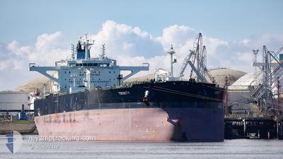
TRINITY
Tanker
Current Trip
CACAPT
| Time Travelled | 5 days |
|---|---|
| Remaining Time | --- |
| Distance Travelled | 1608.76 nm |
| Remaining Distance | --- |
| AVG Speed | 12.9 Noeuds |
| MAX Speed | 16 Noeuds |
| AVG Wind | 12.8 knots |
| MAX Wind | 24.3 knots |
| MIN Temp | 9.6°C / 49.28°F |
| MAX Temp | 26.5°C / 79.7°F |
| Tirant d eau | 13.7 m |
| Position reçue | 1 d depuis |
Current Position
| Longitude | --- |
|---|---|
| Latitude | --- |
| Etat | Under way using engine |
| Vitesse | 11.9 Noeuds |
| Parcours | 84.6° |
| Zone | North Atlantic Ocean |
| Station | T-AIS |
| Position reçue | 1 d depuis |
Info
Information
The current position of TRINITY is in North Atlantic Ocean with coordinates 27.83590° / -78.24862° as reported on 2025-12-05 19:04 by AIS to our vessel tracker app. The vessel's current speed is 11.9 Noeuds
The vessel TRINITY (IMO: 9730361, MMSI: 538006699) is a Tanker It's sailing under the flag of [MH] Marshall Is.
In this page you can find informations about the vessels current position, last detected port calls, and current voyage information. If the vessels is not in coverage by AIS you will find the latest position.
The current position of TRINITY is detected by our AIS receivers and we are not responsible for the reliability of the data. The last position was recorded while the vessel was in Coverage by the Ais receivers of our vessel tracking app.
The current draught of TRINITY as reported by AIS is 13.7 meters
Weather
| Temperature | 22.7°C / 72.86°F |
|---|---|
| Wind Speed | 18 knots |
| Direction | 250° WSW |
| Pressure | 1012.8 hPa |
| Humidity | 89.5 % |
| Cloud Coverage | 65 % |
Featured Company
Most Visited Ports (Last year)
| Port | Arrivals | |
|---|---|---|
| 4 | ||
| 1 | ||
| 1 | ||
| 1 | ||
| 1 | ||
| 1 |
Events
| Heure | Evenement | Détails | Position/ Destination | Info |
|---|---|---|---|---|
| 2025-12-05 19:10 | Etat Changé | Default Under way using engine |
27.83819 / -78.22582
CACAPT
|
Vitesse: 11.9 kn Parcours: 84.6° |
| 2025-12-05 19:04 | Etat Changé | Under way using engine Default |
27.83590 / -78.24862
CACAPT
|
Vitesse: 12 kn Parcours: 85° |
| 2025-12-05 19:04 | Hors de la zone couverte |
27.83590 / -78.24862
North Atlantic Ocean
|
Vitesse: 11.9 kn Parcours: 84.6° |
|
| 2025-12-05 18:46 | Etat Changé | Default Under way using engine |
27.83045 / -78.31587
CACAPT
|
Vitesse: 12 kn Parcours: 84° |
| 2025-12-05 18:27 | Etat Changé | Under way using engine Default |
27.82429 / -78.38792
CACAPT
|
Vitesse: 12.1 kn Parcours: 84° |
| 2025-12-05 18:20 | Etat Changé | Default Under way using engine |
27.82199 / -78.41389
CACAPT
|
Vitesse: 12.2 kn Parcours: 79.4° |
| 2025-12-05 16:58 | Etat Changé | Under way using engine Default |
27.77990 / -78.73679
CACAPT
|
Vitesse: 12.4 kn Parcours: 84° |
| 2025-12-05 16:19 | Etat Changé | Default Under way using engine |
27.76487 / -78.87974
CACAPT
|
Vitesse: 12 kn Parcours: 85° |
| 2025-12-05 16:14 | Etat Changé | Under way using engine Default |
27.76322 / -78.89944
CACAPT
|
Vitesse: 12.5 kn Parcours: 86° |
| 2025-12-05 15:59 | Etat Changé | Default Under way using engine |
27.75923 / -78.95703
CACAPT
|
Vitesse: 12 kn Parcours: 85° |