
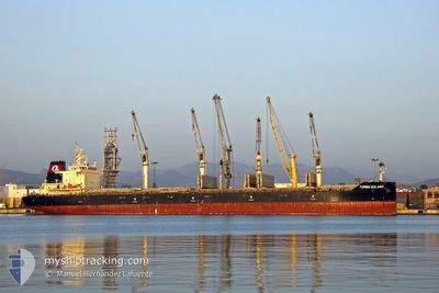
TOMINI SOLANO
Cargo
Current Trip
| Time Travelled | 7 days |
|---|---|
| Remaining Time | 8 h, 23 mins |
| Distance Travelled | 977.48 nm |
| Remaining Distance | 105.66 nm |
| AVG Speed | 12.7 Noeuds |
| MAX Speed | 15 Noeuds |
| AVG Wind | 9.4 knots |
| MAX Wind | 18 knots |
| MIN Temp | 22.6°C / 72.68°F |
| MAX Temp | 25.4°C / 77.72°F |
| Tirant d eau | 7 m |
| Position reçue | 6 m depuis |
Current Position
| Longitude | --- |
|---|---|
| Latitude | --- |
| Etat | Under way using engine |
| Vitesse | 12.5 Noeuds |
| Parcours | 254.5° |
| Zone | Persian Gulf |
| Station | T-AIS |
| Position reçue | 6 m depuis |
Info
Information
The current position of TOMINI SOLANO is in Persian Gulf with coordinates 25.78994° / 55.42427° as reported on 2025-12-05 11:21 by AIS to our vessel tracker app. The vessel's current speed is 12.5 Noeuds and is heading at the port of ABU DHABI. The estimated time of arrival as calculated by MyShipTracking vessel tracking app is 2025-12-05 23:51 LT
The vessel TOMINI SOLANO (IMO: 9711731, MMSI: 538005695) is a Cargo It's sailing under the flag of [MH] Marshall Is.
In this page you can find informations about the vessels current position, last detected port calls, and current voyage information. If the vessels is not in coverage by AIS you will find the latest position.
The current position of TOMINI SOLANO is detected by our AIS receivers and we are not responsible for the reliability of the data. The last position was recorded while the vessel was in Coverage by the Ais receivers of our vessel tracking app.
The current draught of TOMINI SOLANO as reported by AIS is 7 meters
Weather
| Temperature | 25.4°C / 77.72°F |
|---|---|
| Wind Speed | 7 knots |
| Direction | 12° NNE |
| Pressure | 1017.1 hPa |
| Humidity | 63.9 % |
| Cloud Coverage | 100 % |
Featured Company
Last Port Calls
| Port | Arrival | Departure | Time In Port |
|---|---|---|---|
| 2025-11-25 17:51 | 2025-11-28 01:07 | 2 d | |
| 2025-10-06 02:11 |
Most Visited Ports (Last year)
| Port | Arrivals | |
|---|---|---|
| 2 | ||
| 1 | ||
| 1 | ||
| 1 | ||
| 1 | ||
| 1 |
Last Trips
| Origin | Departure | Destination | Arrival | Distance | |
|---|---|---|---|---|---|
| 2025-10-06 02:11 | 2025-11-25 17:51 | 13062.22 nm |
Events
| Heure | Evenement | Détails | Position/ Destination | Info |
|---|---|---|---|---|
| 2025-12-05 09:07 | Changement de zone | United Arab Emirates part of the Persian Gulf Omani part of the Gulf of Oman |
25.96604 / 55.89656
Persian Gulf
AEMZD
|
Vitesse: 12.5 kn Parcours: 234.2° |
| 2025-12-05 09:07 | Etat Changé | Under way using engine Default |
25.96658 / 55.89739
AEMZD
|
Vitesse: 12.6 kn Parcours: 235° |
| 2025-12-05 08:49 | Dans la zone couverte |
25.96604 / 55.89656
Persian Gulf
AEMZD
|
Vitesse: 12.5 kn Parcours: 234.2° |
|
| 2025-12-05 01:20 | Etat Changé | Default Under way using engine |
25.92500 / 56.81333
AEMZD
|
Vitesse: 13.4 kn Parcours: 355.6° |
| 2025-12-05 01:14 | Hors de la zone couverte |
25.90177 / 56.81526
Gulf of Oman
AEMZD
|
Vitesse: 13.4 kn Parcours: 355.6° |
|
| 2025-12-05 00:11 | Changement de zone | Omani part of the Gulf of Oman United Arab Emirates part of the Gulf of Oman |
25.66709 / 56.83077
Gulf of Oman
AEMZD
|
Vitesse: 13.5 kn Parcours: 357.1° |
| 2025-12-04 22:05 | Tirant d'eau modifié | 7 9.3 |
25.21994 / 56.79586
AEMZD
|
Vitesse: 12.8 kn Parcours: 4.3° |
| 2025-12-04 22:05 | Changement de destination | AEMZD IN IXY |
25.21994 / 56.79586
AEMZD
|
Vitesse: 12.8 kn Parcours: 4.3° |
| 2025-12-04 22:05 | Changement d'ETA | 2025/12/05 20:00 2025/11/23 06:30 |
25.21994 / 56.79586
AEMZD
|
Vitesse: 12.8 kn Parcours: 4.3° |
| 2025-12-04 21:19 | Changement de zone | United Arab Emirates part of the Gulf of Oman Omani part of the Gulf of Oman |
25.06953 / 56.85761
Gulf of Oman
|
Vitesse: 12.7 kn Parcours: 331.6° |