
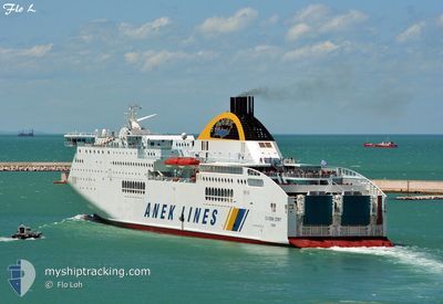
SUPERFAST IV
Ro-Ro/Passenger Ship
Current Trip
| Time Travelled | 14 h, 1 mins |
|---|---|
| Remaining Time | --- |
| Distance Travelled | 274.81 nm |
| Remaining Distance | --- |
| AVG Speed | 22.6 Noeuds |
| MAX Speed | 24.1 Noeuds |
| AVG Wind | 3.5 knots |
| MAX Wind | 15.2 knots |
| MIN Temp | 10.2°C / 50.36°F |
| MAX Temp | 16.1°C / 60.98°F |
| Tirant d eau | 6.3 m |
| Position reçue | 30 m depuis |
Current Position
| Longitude | --- |
|---|---|
| Latitude | --- |
| Etat | Under way using engine |
| Vitesse | 22.5 Noeuds |
| Parcours | 311.5° |
| Zone | Adriatic Sea |
| Station | T-AIS |
| Position reçue | 30 m depuis |
Info
Information
The current position of SUPERFAST IV is in Adriatic Sea with coordinates 41.26570° / 17.78105° as reported on 2025-12-11 07:21 by AIS to our vessel tracker app. The vessel's current speed is 22.5 Noeuds
The vessel SUPERFAST IV (IMO: 9216030, MMSI: 239806000) is a Ro-Ro/Passenger Ship that was built in 2001 ( 24 Age ). It's sailing under the flag of [GR] Greece.
In this page you can find informations about the vessels current position, last detected port calls, and current voyage information. If the vessels is not in coverage by AIS you will find the latest position.
The current position of SUPERFAST IV is detected by our AIS receivers and we are not responsible for the reliability of the data. The last position was recorded while the vessel was in Coverage by the Ais receivers of our vessel tracking app.
The current draught of SUPERFAST IV as reported by AIS is 6.3 meters
Weather
| Temperature | 14.8°C / 58.64°F |
|---|---|
| Wind Speed | 14 knots |
| Direction | 322° NW |
| Pressure | 1022.3 hPa |
| Humidity | 80.7 % |
| Cloud Coverage | 64 % |
Featured Company
Last Port Calls
| Port | Arrival | Departure | Time In Port |
|---|---|---|---|
| 2025-12-10 16:24 | 2025-12-10 19:50 | 3 h | |
| 2025-12-09 14:53 | 2025-12-09 17:57 | 3 h | |
| 2025-12-08 11:14 | 2025-12-08 21:58 | 10 h | |
| 2025-12-07 14:09 | 2025-12-07 17:29 | 3 h | |
| 2025-12-06 13:56 | 2025-12-06 16:47 | 2 h | |
| 2025-12-04 17:01 | 2025-12-05 15:01 | 22 h | |
| 2025-12-03 23:08 | 2025-12-04 00:15 | 1 h | |
| 2025-11-30 17:59 | 2025-12-03 17:47 | 2 d | |
| 2025-11-29 15:25 | 2025-11-29 19:25 | 3 h | |
| 2025-11-28 23:04 | 2025-11-29 00:20 | 1 h |
Most Visited Ports (Last year)
| Port | Arrivals | |
|---|---|---|
| 100 | ||
| 69 | ||
| 65 | ||
| 4 | ||
| 3 |
Last Trips
| Origin | Departure | Destination | Arrival | Distance | |
|---|---|---|---|---|---|
| 2025-12-09 17:57 | 2025-12-10 16:24 | 519.76 nm | |||
| 2025-12-08 21:58 | 2025-12-09 14:53 | 383.05 nm | |||
| 2025-12-07 17:29 | 2025-12-08 11:14 | 401.87 nm | |||
| 2025-12-06 16:47 | 2025-12-07 14:09 | 526.56 nm | |||
| 2025-12-05 15:01 | 2025-12-06 13:56 | 518.86 nm | |||
| 2025-12-04 00:15 | 2025-12-04 17:01 | 396.16 nm | |||
| 2025-12-03 17:47 | 2025-12-03 23:08 | 122.75 nm | |||
| 2025-11-29 19:25 | 2025-11-30 17:59 | 518.72 nm | |||
| 2025-11-29 00:20 | 2025-11-29 15:25 | 402.00 nm | |||
| 2025-11-28 17:57 | 2025-11-28 23:04 | 125.02 nm |
Events
| Heure | Evenement | Détails | Position/ Destination | Info |
|---|---|---|---|---|
| 2025-12-11 07:28 | Etat Changé | Default Under way using engine |
41.29650 / 17.73499
ITAOI
|
Vitesse: 22.5 kn Parcours: 311.5° |
| 2025-12-11 07:17 | Detecté en mer | Italian part of the Adriatic Sea |
41.25246 / 17.80104
Adriatic Sea
ITAOI
|
Vitesse: 22.5 kn Parcours: 311.3° |
| 2025-12-11 07:16 | Etat Changé | Under way using engine Default |
41.24510 / 17.81219
ITAOI
|
Vitesse: 22.4 kn Parcours: 312° |
| 2025-12-11 07:16 | Dans la zone couverte |
41.25246 / 17.80104
Adriatic Sea
ITAOI
|
Vitesse: 22.5 kn Parcours: 311.3° |
|
| 2025-12-11 04:11 | Etat Changé | Default Under way using engine |
40.49021 / 18.97020
ITAOI
|
Vitesse: 23.5 kn Parcours: 311.1° |
| 2025-12-11 04:09 | Etat Changé | Under way using engine Default |
40.47830 / 18.98794
ITAOI
|
Vitesse: 23.4 kn Parcours: 314° |
| 2025-12-11 04:09 | Dans la zone couverte |
40.47830 / 18.98794
Adriatic Sea
ITAOI
|
Vitesse: 23.5 kn Parcours: 311.1° |
|
| 2025-12-11 04:09 | Hors de la zone couverte |
40.47830 / 18.98794
Adriatic Sea
ITAOI
|
Vitesse: 23.5 kn Parcours: 311.1° |
|
| 2025-12-11 02:45 | Etat Changé | Default Under way using engine |
40.11205 / 19.52213
ITAOI
|
Vitesse: 23.3 kn Parcours: 309° |
| 2025-12-11 02:39 | Hors de la zone couverte |
40.08891 / 19.55969
Adriatic Sea
ITAOI
|
Vitesse: 23.3 kn Parcours: 309° |