
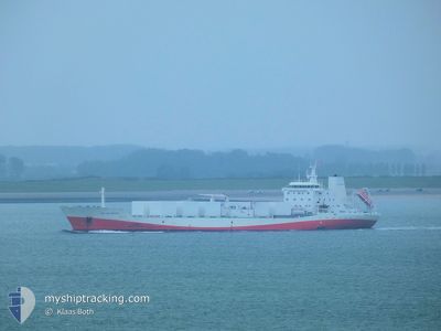
SOL DO BRASIL
Fruit Juice Tanker
Current Trip
BR SSZ
| Time Travelled | 15 h, 55 mins |
|---|---|
| Remaining Time | --- |
| Distance Travelled | 219.42 nm |
| Remaining Distance | --- |
| AVG Speed | 14.6 Noeuds |
| MAX Speed | 15.4 Noeuds |
| AVG Wind | 7.7 knots |
| MAX Wind | 15 knots |
| MIN Temp | 18.4°C / 65.12°F |
| MAX Temp | 23.5°C / 74.3°F |
| Tirant d eau | 6.9 m |
| Position reçue | 3 h, 50 m depuis |
Current Position
| Longitude | -43.41242° |
|---|---|
| Latitude | -23.96294° |
| Etat | Under way using engine |
| Vitesse | 14.5 Noeuds |
| Parcours | 78.5° |
| Zone | South Atlantic Ocean |
| Station | T-AIS |
| Position reçue | 3 h, 50 m depuis |
Info
Information
The current position of SOL DO BRASIL is in South Atlantic Ocean with coordinates -23.96294° / -43.41242° as reported on 2024-06-08 20:40 by AIS to our vessel tracker app. The vessel's current speed is 14.5 Noeuds
The vessel SOL DO BRASIL (IMO: 9018658, MMSI: 636010032) is a Fruit Juice Tanker that was built in 1994 ( 30 Age ). It's sailing under the flag of [LR] Liberia.
In this page you can find informations about the vessels current position, last detected port calls, and current voyage information. If the vessels is not in coverage by AIS you will find the latest position.
The current position of SOL DO BRASIL is detected by our AIS receivers and we are not responsible for the reliability of the data. The last position was recorded while the vessel was in Coverage by the Ais receivers of our vessel tracking app.
The current draught of SOL DO BRASIL as reported by AIS is 6.9 meters
Weather
| Temperature | 23.3°C / 73.94°F |
|---|---|
| Wind Speed | 15 knots |
| Direction | 71° ENE |
| Pressure | 1022.4 hPa |
| Humidity | 76.9 % |
| Cloud Coverage | 2 % |
Featured Company
Last Port Calls
| Port | Arrival | Departure | Time In Port |
|---|---|---|---|
| 2024-06-05 06:03 | 2024-06-08 05:35 | 2 d | |
| 2024-04-22 13:17 | 2024-05-23 14:25 | ||
| 2024-04-05 22:25 | 2024-04-09 02:29 | 3 d |
Most Visited Ports (Last year)
| Port | Arrivals | |
|---|---|---|
| 8 | ||
| 6 | ||
| 2 | ||
| 2 | ||
| 1 | ||
| 1 |
Last Trips
| Origin | Departure | Destination | Arrival | Distance | |
|---|---|---|---|---|---|
| 2024-05-23 14:25 | 2024-06-05 06:03 | 1400.19 nm | |||
| 2024-04-09 02:29 | 2024-04-22 13:17 | 4265.52 nm | |||
| 2024-03-31 14:15 | 2024-04-05 22:25 | 1393.01 nm |
Events
| Heure | Evenement | Détails | Position/ Destination | Info |
|---|---|---|---|---|
| 2024-06-08 23:45 | Arret |
-23.82648 / -42.71965
BR SSZ
|
Vitesse: 0.2 kn Parcours: 42° |
|
| 2024-06-08 20:45 | Etat Changé | Default Under way using engine |
-23.95889 / -43.38911
BR SSZ
|
Vitesse: 14.5 kn Parcours: 78.5° |
| 2024-06-08 20:40 | Hors de la zone couverte |
-23.96294 / -43.41242
South Atlantic Ocean
|
Vitesse: 14.5 kn Parcours: 78.5° |
|
| 2024-06-08 20:37 | Etat Changé | Under way using engine Default |
-23.96497 / -43.42366
BR SSZ
|
Vitesse: 14.3 kn Parcours: 79° |
| 2024-06-08 20:29 | Dans la zone couverte |
-23.96481 / -43.42280
South Atlantic Ocean
|
Vitesse: 14.5 kn Parcours: 78.7° |
|
| 2024-06-08 11:33 | Etat Changé | Default Under way using engine |
-24.25814 / -45.88644
BR SSZ
|
Vitesse: 15.1 kn Parcours: 90.3° |
| 2024-06-08 11:28 | Hors de la zone couverte |
-24.25803 / -45.90615
South Atlantic Ocean
|
Vitesse: 15.1 kn Parcours: 90.3° |
|
| 2024-06-08 11:12 | Etat Changé | Under way using engine Default |
-24.25785 / -45.98090
BR SSZ
|
Vitesse: 15 kn Parcours: 90° |
| 2024-06-08 10:48 | Etat Changé | Default Under way using engine |
-24.25697 / -46.08918
BR SSZ
|
Vitesse: 14.5 kn Parcours: 90.2° |
| 2024-06-08 10:44 | Etat Changé | Under way using engine Default |
-24.25686 / -46.10822
BR SSZ
|
Vitesse: 14.5 kn Parcours: 90° |