
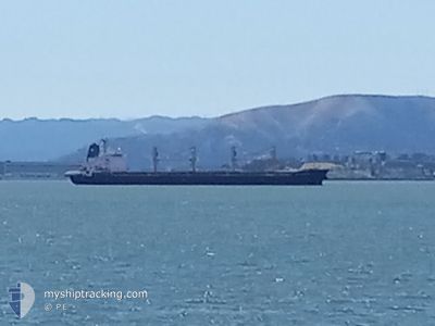
SEASTAR VALIANT
Bulk Carrier
Current Trip
| Trip Time | 3 days |
|---|---|
| Trip Distance | 730.13 nm |
| AVG Speed | 10.1 Noeuds |
| MAX Speed | 11.9 Noeuds |
| Tirant d eau | 9.7 m |
| AVG Wind | 6.9 knots |
| MAX Wind | 15.8 knots |
| MIN Temp | 15.1°C / 59.18°F |
| MAX Temp | 26.3°C / 79.34°F |
| Position reçue | 7 d depuis |
Current Position
| Longitude | --- |
|---|---|
| Latitude | --- |
| Etat | Under way using engine |
| Vitesse | 11.6 Noeuds |
| Parcours | 207° |
| Zone | Gulf of Mexico |
| Station | T-AIS |
| Position reçue | 7 d depuis |
Info
Information
The current position of SEASTAR VALIANT is in Gulf of Mexico with coordinates 29.77911° / -90.02104° as reported on 2025-12-04 12:07 by AIS to our vessel tracker app. The vessel's current speed is 11.6 Noeuds and is currently inside the port of TUXPAN.
The vessel SEASTAR VALIANT (IMO: 9462768, MMSI: 215869000) is a Bulk Carrier that was built in 2012 ( 13 Age ). It's sailing under the flag of [MT] Malta.
In this page you can find informations about the vessels current position, last detected port calls, and current voyage information. If the vessels is not in coverage by AIS you will find the latest position.
The current position of SEASTAR VALIANT is detected by our AIS receivers and we are not responsible for the reliability of the data. The last position was recorded while the vessel was in Coverage by the Ais receivers of our vessel tracking app.
The current draught of SEASTAR VALIANT as reported by AIS is 9.7 meters
Weather
| Temperature | 22.2°C / 71.96°F |
|---|---|
| Wind Speed | 6 knots |
| Direction | 293° WNW |
| Pressure | 1017.4 hPa |
| Humidity | 86.7 % |
| Cloud Coverage | 100 % |
Featured Company
Last Port Calls
| Port | Arrival | Departure | Time In Port |
|---|---|---|---|
| 2025-12-07 20:27 | |||
| 2025-12-04 07:27 | 2025-12-04 12:15 | 4 h | |
| 2025-11-30 13:21 | 2025-12-01 05:27 | 16 h | |
| 2025-11-22 01:25 | 2025-11-27 17:44 | 5 d | |
| 2025-10-27 19:13 | 2025-11-01 22:18 | 5 d |
Last Trips
| Origin | Departure | Destination | Arrival | Distance | |
|---|---|---|---|---|---|
| 2025-12-04 06:15 | 2025-12-07 14:27 | 730.13 nm | |||
| 2025-11-30 23:27 | 2025-12-04 01:27 | 75.79 nm | |||
| 2025-11-27 12:44 | 2025-11-30 07:21 | 467.90 nm | |||
| 2025-11-01 23:18 | 2025-11-21 20:25 | 4390.34 nm | |||
| 2025-09-28 15:17 | 2025-10-27 20:13 | 552.14 nm |
Events
| Heure | Evenement | Détails | Position/ Destination | Info |
|---|---|---|---|---|
| 2025-12-07 21:13 | Arret |
20.95024 / -97.34718
[MX] TUXPAN
|
Vitesse: 0.1 kn Parcours: 232° |
|
| 2025-12-07 20:27 | Port d'arrivée |
|
20.96835 / -97.30834
[MX] TUXPAN
|
Vitesse: 8.8 kn Parcours: 241° |
| 2025-12-07 19:49 | Démarrage | 4.91 nm, East of TUXPAN |
20.98568 / -97.24352
USMSY>MXTUX
|
Vitesse: 3.4 kn Parcours: 333° |
| 2025-12-07 13:11 | Arret | 4.97 nm, East of TUXPAN |
20.98159 / -97.24130
USMSY>MXTUX
|
Vitesse: 0.2 kn Parcours: 5° |
| 2025-12-07 12:45 | Démarrage | 4.72 nm, East of TUXPAN |
20.98752 / -97.24777
USMSY>MXTUX
|
Vitesse: 5.3 kn Parcours: 180° |
| 2025-12-07 11:56 | Arret | 5.32 nm, North East of TUXPAN |
21.00445 / -97.24367
USMSY>MXTUX
|
Vitesse: 0.3 kn Parcours: 308° |
| 2025-12-04 12:15 | Etat Changé | Default Under way using engine |
29.75558 / -90.02444
USMSY>MXTUX
|
Vitesse: 11.6 kn Parcours: 207° |
| 2025-12-04 12:15 | PORT DE DEPART |
|
29.75558 / -90.02444
USMSY>MXTUX
|
Vitesse: 11.6 kn Parcours: 207° |
| 2025-12-04 12:07 | Hors de la zone couverte |
29.77911 / -90.02104
Gulf of Mexico
USMSY>MXTUX
|
Vitesse: 11.6 kn Parcours: 210.4° |
|
| 2025-12-04 09:32 | Tirant d'eau modifié | 9.7 6 |
29.90780 / -90.10593
[US] NEW ORLEANS
|
Vitesse: 9.7 kn Parcours: 81° |