
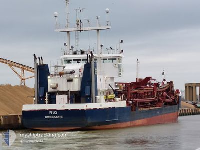
RIO
Trailing Suction Hopper Dredger
Current Trip
| Trip Time | 1 day |
|---|---|
| Trip Distance | 268.09 nm |
| AVG Speed | 7.2 Noeuds |
| MAX Speed | 8.2 Noeuds |
| Tirant d eau | 3.4 m |
| AVG Wind | 8.9 knots |
| MAX Wind | 17.7 knots |
| MIN Temp | 16.4°C / 61.52°F |
| MAX Temp | 21.9°C / 71.42°F |
| Position reçue | 5 m depuis |
Current Position
| Longitude | --- |
|---|---|
| Latitude | --- |
| Etat | At anchor |
| Vitesse | 0.1 Noeuds |
| Parcours | 270° |
| Zone | Mediterranean Sea - Eastern Basin |
| Station | T-AIS |
| Position reçue | 5 m depuis |
Info
Information
The current position of RIO is in Mediterranean Sea - Eastern Basin with coordinates 34.64526° / 33.01059° as reported on 2025-12-08 02:21 by AIS to our vessel tracker app. The vessel's current speed is 0.1 Noeuds and is currently inside the port of LIMASSOL.
The vessel RIO (IMO: 8613047, MMSI: 245618000) is a Trailing Suction Hopper Dredger that was built in 1987 ( 38 Age ). It's sailing under the flag of [NL] Netherlands.
In this page you can find informations about the vessels current position, last detected port calls, and current voyage information. If the vessels is not in coverage by AIS you will find the latest position.
The current position of RIO is detected by our AIS receivers and we are not responsible for the reliability of the data. The last position was recorded while the vessel was in Coverage by the Ais receivers of our vessel tracking app.
The current draught of RIO as reported by AIS is 3.4 meters
Weather
| Temperature | 12.2°C / 53.96°F |
|---|---|
| Wind Speed | 3 knots |
| Direction | 337° NNW |
| Pressure | 1011.3 hPa |
| Humidity | 89.4 % |
| Cloud Coverage | 100 % |
Featured Company
Last Port Calls
| Port | Arrival | Departure | Time In Port |
|---|---|---|---|
| 2025-12-06 08:45 | |||
| 2025-11-29 02:05 | 2025-12-04 19:04 | 5 d | |
| 2025-11-28 17:13 | 2025-11-29 00:40 | 7 h | |
| 2025-11-28 05:29 | 2025-11-28 15:49 | 10 h | |
| 2025-11-27 22:37 | 2025-11-28 04:09 | 5 h | |
| 2025-11-27 06:41 | 2025-11-27 20:45 | 14 h | |
| 2025-11-26 19:09 | 2025-11-27 05:13 | 10 h | |
| 2025-11-26 08:16 | 2025-11-26 17:48 | 9 h | |
| 2025-11-26 00:37 | 2025-11-26 06:00 | 5 h | |
| 2025-11-25 05:14 | 2025-11-25 23:08 | 17 h |
Most Visited Ports (Last year)
| Port | Arrivals | |
|---|---|---|
| 310 | ||
| 43 | ||
| 36 | ||
| 16 | ||
| 6 | ||
| 4 |
Last Trips
| Origin | Departure | Destination | Arrival | Distance | |
|---|---|---|---|---|---|
| 2025-12-04 19:04 | 2025-12-06 08:45 | 268.09 nm | |||
| 2025-11-29 00:40 | 2025-11-29 02:05 | 2.24 nm | |||
| 2025-11-28 15:49 | 2025-11-28 17:13 | 2.53 nm | |||
| 2025-11-28 04:09 | 2025-11-28 05:29 | 1.71 nm | |||
| 2025-11-27 20:45 | 2025-11-27 22:37 | 2.55 nm | |||
| 2025-11-27 05:13 | 2025-11-27 06:41 | 2.13 nm | |||
| 2025-11-26 17:48 | 2025-11-26 19:09 | 2.42 nm | |||
| 2025-11-26 06:00 | 2025-11-26 08:16 | 3.02 nm | |||
| 2025-11-25 23:08 | 2025-11-26 00:37 | 1.45 nm | |||
| 2025-11-25 03:40 | 2025-11-25 05:14 | 1.67 nm |
Events
| Heure | Evenement | Détails | Position/ Destination | Info |
|---|---|---|---|---|
| 2025-12-06 07:06 | Arret |
34.64524 / 33.01059
[CY] LIMASSOL
|
Vitesse: 0.1 kn Parcours: 268° |
|
| 2025-12-06 06:45 | Port d'arrivée |
|
34.65212 / 33.03352
[CY] LIMASSOL
|
Vitesse: 7.1 kn Parcours: 263.5° |
| 2025-12-06 06:38 | Démarrage | 1.06 nm, East of LIMASSOL |
34.65386 / 33.05024
CYLMS
|
Vitesse: 5.2 kn Parcours: 280.7° |
| 2025-12-06 06:33 | Arret | 1.17 nm, East of LIMASSOL |
34.65303 / 33.05239
CYLMS
|
Vitesse: 0.2 kn Parcours: 328° |
| 2025-12-06 02:31 | Changement de destination | CYLMS EGEDK |
34.25126 / 32.77309
CYLMS
|
Vitesse: 7.7 kn Parcours: 40.7° |
| 2025-12-06 02:26 | Etat Changé | At anchor Default |
34.24312 / 32.76486
EGEDK
|
Vitesse: 7.6 kn Parcours: 40° |
| 2025-12-06 02:26 | Dans la zone couverte |
34.24528 / 32.76702
Mediterranean Sea - Eastern Basin
|
Vitesse: 7.6 kn Parcours: 40.4° |
|
| 2025-12-06 01:11 | Etat Changé | Default At anchor |
34.12162 / 32.64530
EGEDK
|
Vitesse: 7.3 kn Parcours: 35.4° |
| 2025-12-06 01:06 | Etat Changé | At anchor Default |
34.11316 / 32.63768
EGEDK
|
Vitesse: 7.3 kn Parcours: 36° |
| 2025-12-06 01:06 | Hors de la zone couverte |
34.11316 / 32.63768
Mediterranean Sea - Eastern Basin
|
Vitesse: 7.3 kn Parcours: 35.4° |