
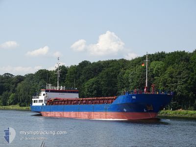
RIG
General Cargo
Current Trip
| Time Travelled | 2 days |
|---|---|
| Remaining Time | 1 day |
| Distance Travelled | 459.88 nm |
| Remaining Distance | 421.22 nm |
| AVG Speed | 8.1 Noeuds |
| MAX Speed | 11.4 Noeuds |
| AVG Wind | 9 knots |
| MAX Wind | 13.9 knots |
| MIN Temp | 9.8°C / 49.64°F |
| MAX Temp | 19.7°C / 67.46°F |
| Tirant d eau | 3.8 m |
| Position reçue | Maintenant |
Current Position
| Longitude | 13.76544° |
|---|---|
| Latitude | 54.93400° |
| Etat | Under way using engine |
| Vitesse | 10.6 Noeuds |
| Parcours | 71.2° |
| Zone | Baltic Sea |
| Station | T-AIS |
| Position reçue | Maintenant |
Info
Information
The current position of RIG is in Baltic Sea with coordinates 54.93400° / 13.76544° as reported on 2024-05-19 18:39 by AIS to our vessel tracker app. The vessel's current speed is 10.6 Noeuds and is heading at the port of RIGA. The estimated time of arrival as calculated by MyShipTracking vessel tracking app is 2024-05-21 15:37 LT
The vessel RIG (IMO: 8801137, MMSI: 305042000) is a General Cargo that was built in 1989 ( 35 Age ). It's sailing under the flag of [AG] Antigua Barbuda.
In this page you can find informations about the vessels current position, last detected port calls, and current voyage information. If the vessels is not in coverage by AIS you will find the latest position.
The current position of RIG is detected by our AIS receivers and we are not responsible for the reliability of the data. The last position was recorded while the vessel was in Coverage by the Ais receivers of our vessel tracking app.
The current draught of RIG as reported by AIS is 3.8 meters
Weather
| Temperature | 12.7°C / 54.86°F |
|---|---|
| Wind Speed | 9 knots |
| Direction | 74° ENE |
| Pressure | 1010.2 hPa |
| Humidity | 85.9 % |
| Cloud Coverage | 5 % |
Featured Company
Last Port Calls
| Port | Arrival | Departure | Time In Port |
|---|---|---|---|
| 2024-05-16 04:31 | 2024-05-17 15:44 | 1 d | |
| 2024-05-09 17:55 | 2024-05-12 19:02 | 3 d | |
| 2024-05-08 05:55 | 2024-05-08 17:26 | 11 h | |
| 2024-05-07 08:47 | 2024-05-07 08:49 | 1 m | |
| 2024-05-05 06:28 | 2024-05-06 19:35 | 1 d | |
| 2024-04-30 17:44 | 2024-05-03 17:08 | 2 d | |
| 2024-04-24 19:44 | 2024-04-26 12:16 | 1 d | |
| 2024-04-18 19:51 | 2024-04-18 19:53 | 2 m | |
| 2024-04-17 09:15 | 2024-04-18 00:44 | 15 h | |
| 2024-04-11 05:05 | 2024-04-12 19:30 | 1 d |
Last Trips
| Origin | Departure | Destination | Arrival | Distance | |
|---|---|---|---|---|---|
| 2024-05-12 19:02 | 2024-05-16 04:31 | 699.25 nm | |||
| 2024-05-08 17:26 | 2024-05-09 17:55 | 227.23 nm | |||
| 2024-05-07 08:49 | 2024-05-08 05:55 | 193.03 nm | |||
| 2024-05-06 19:35 | 2024-05-07 08:47 | 88.34 nm | |||
| 2024-05-03 17:08 | 2024-05-05 06:28 | 84.99 nm | |||
| 2024-04-26 12:16 | 2024-04-30 17:44 | 904.07 nm | |||
| 2024-04-18 19:53 | 2024-04-24 19:44 | 931.71 nm | |||
| 2024-04-18 00:44 | 2024-04-18 19:51 | 144.45 nm | |||
| 2024-04-12 19:30 | 2024-04-17 09:15 | 532.62 nm | |||
| 2024-04-09 10:18 | 2024-04-11 05:05 | 369.55 nm |
Events
| Heure | Evenement | Détails | Position/ Destination | Info |
|---|---|---|---|---|
| 2024-05-19 17:22 | Etat Changé | Under way using engine Default |
54.86433 / 13.39867
LV RIX
|
Vitesse: 10.1 kn Parcours: 73° |
| 2024-05-19 17:21 | Etat Changé | Default Under way using engine |
54.86346 / 13.39403
LV RIX
|
Vitesse: 10.2 kn Parcours: 70° |
| 2024-05-19 17:13 | Etat Changé | Under way using engine Default |
54.85597 / 13.35886
LV RIX
|
Vitesse: 10.4 kn Parcours: 71° |
| 2024-05-19 17:05 | Etat Changé | Default Under way using engine |
54.84819 / 13.31885
LV RIX
|
Vitesse: 10.4 kn Parcours: 71.9° |
| 2024-05-19 11:50 | Changement de zone | German part of the Baltic Sea Danish part of the Baltic Sea |
54.40897 / 12.10842
Baltic Sea
LV RIX
|
Vitesse: 10.3 kn Parcours: 88.2° |
| 2024-05-19 09:32 | Changement de zone | Danish part of the Baltic Sea German part of the Baltic Sea |
54.48926 / 11.46663
Baltic Sea
LV RIX
|
Vitesse: 10.3 kn Parcours: 114.1° |
| 2024-05-19 06:53 | Detecté en mer | German part of the Baltic Sea |
54.55477 / 10.75367
Baltic Sea
LV RIX
|
Vitesse: 9.9 kn Parcours: 83.8° |
| 2024-05-19 06:29 | Changement de zone | Danish part of the Baltic Sea German part of the Baltic Sea |
54.54951 / 10.64429
Baltic Sea
LV RIX
|
Vitesse: 9.3 kn Parcours: 84.8° |
| 2024-05-19 05:25 | Changement d'ETA | 2024/05/21 11:00 2024/05/21 04:00 |
54.49595 / 10.36807
LV RIX
|
Vitesse: 10.3 kn Parcours: 67.3° |
| 2024-05-19 05:02 | Changement de zone | German part of the Baltic Sea German part of the North Sea |
54.46173 / 10.27610
Baltic Sea
LV RIX
|
Vitesse: 9.7 kn Parcours: 41.7° |