
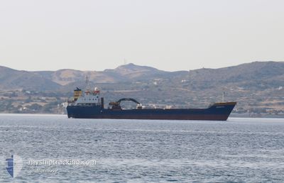
RENATA
General Cargo
Current Trip
GR NKV
| Time Travelled | 7 h, 37 mins |
|---|---|
| Remaining Time | --- |
| Distance Travelled | --- |
| Remaining Distance | --- |
| AVG Speed | --- |
| MAX Speed | --- |
| AVG Wind | --- |
| MAX Wind | --- |
| MIN Temp | --- |
| MAX Temp | --- |
| Tirant d eau | 3.5 m |
| Position reçue | 2 d depuis |
Current Position
| Longitude | --- |
|---|---|
| Latitude | --- |
| Etat | Under way using engine |
| Vitesse | 7.5 Noeuds |
| Parcours | 341.6° |
| Zone | Aegean Sea |
| Station | T-AIS |
| Position reçue | 2 d depuis |
Info
Information
The current position of RENATA is in Aegean Sea with coordinates 38.23171° / 24.60692° as reported on 2025-12-14 16:45 by AIS to our vessel tracker app. The vessel's current speed is 7.5 Noeuds
The vessel RENATA (IMO: 8022872, MMSI: 240136700) is a General Cargo that was built in 1982 ( 43 Age ). It's sailing under the flag of [GR] Greece.
In this page you can find informations about the vessels current position, last detected port calls, and current voyage information. If the vessels is not in coverage by AIS you will find the latest position.
The current position of RENATA is detected by our AIS receivers and we are not responsible for the reliability of the data. The last position was recorded while the vessel was in Coverage by the Ais receivers of our vessel tracking app.
The current draught of RENATA as reported by AIS is 3.5 meters
Weather
| Temperature | 12.5°C / 54.5°F |
|---|---|
| Wind Speed | 5 knots |
| Direction | 59° ENE |
| Pressure | 1025.5 hPa |
| Humidity | 64.9 % |
| Cloud Coverage | 2 % |
Featured Company
Last Port Calls
| Port | Arrival | Departure | Time In Port |
|---|---|---|---|
| 2025-12-15 13:17 | 2025-12-16 18:36 | 1 d | |
| 2025-12-03 10:09 | 2025-12-14 09:17 | 10 d | |
| 2025-11-28 12:01 | 2025-12-03 09:38 | 4 d | |
| 2025-11-24 08:59 | 2025-11-28 11:43 | 4 d | |
| 2025-11-22 06:51 | 2025-11-24 07:29 | 2 d | |
| 2025-11-19 07:06 | 2025-11-19 20:48 | 13 h | |
| 2025-11-18 07:20 | 2025-11-18 13:01 | 5 h | |
| 2025-11-15 19:45 | 2025-11-16 18:04 | 22 h | |
| 2025-11-12 16:32 | 2025-11-14 14:47 | 1 d | |
| 2025-11-08 07:29 | 2025-11-11 15:03 | 3 d |
Most Visited Ports (Last year)
| Port | Arrivals | |
|---|---|---|
| 33 | ||
| 21 | ||
| 14 | ||
| 10 | ||
| 8 | ||
| 5 |
Last Trips
| Origin | Departure | Destination | Arrival | Distance | |
|---|---|---|---|---|---|
| 2025-12-14 09:17 | 2025-12-15 13:17 | 249.80 nm | |||
| 2025-12-03 09:38 | 2025-12-03 10:09 | 1.98 nm | |||
| 2025-11-28 11:43 | 2025-11-28 12:01 | 0.61 nm | |||
| 2025-11-24 07:29 | 2025-11-24 08:59 | 6.84 nm | |||
| 2025-11-19 20:48 | 2025-11-22 06:51 | 246.13 nm | |||
| 2025-11-18 13:01 | 2025-11-19 07:06 | 129.60 nm | |||
| 2025-11-16 18:04 | 2025-11-18 07:20 | 94.06 nm | |||
| 2025-11-14 14:47 | 2025-11-15 19:45 | 255.43 nm | |||
| 2025-11-11 15:03 | 2025-11-12 16:32 | 216.73 nm | |||
| 2025-11-05 10:17 | 2025-11-08 07:29 | 195.27 nm |
Events
| Heure | Evenement | Détails | Position/ Destination | Info |
|---|---|---|---|---|
| 2025-12-16 16:36 | PORT DE DEPART |
|
40.78333 / 24.46500
GR NKV
|
Vitesse: Parcours: 303° |
| 2025-12-15 11:17 | Port d'arrivée |
|
40.94500 / 24.47833
[GR] NEA KARVALI
|
Vitesse: 9 kn Parcours: 9° |
| 2025-12-14 16:48 | Etat Changé | Default Under way using engine |
38.23748 / 24.60443
GR NKV
|
Vitesse: 7.5 kn Parcours: 341.6° |
| 2025-12-14 16:45 | Hors de la zone couverte |
38.23171 / 24.60692
Aegean Sea
GR NKV
|
Vitesse: 7.5 kn Parcours: 341.6° |
|
| 2025-12-14 15:11 | Changement d'ETA | 2025/12/15 09:30 2026/01/01 09:30 |
38.02622 / 24.60274
GR NKV
|
Vitesse: 8.3 kn Parcours: 23° |
| 2025-12-14 14:55 | Etat Changé | Under way using engine Default |
37.99086 / 24.58478
GR NKV
|
Vitesse: 8.4 kn Parcours: 30° |
| 2025-12-14 14:55 | Dans la zone couverte |
37.99086 / 24.58478
Aegean Sea
GR NKV
|
Vitesse: 8.2 kn Parcours: 26.4° |
|
| 2025-12-14 13:26 | Etat Changé | Default Under way using engine |
37.83472 / 24.41211
GR NKV
|
Vitesse: 9.1 kn Parcours: 48.8° |
| 2025-12-14 13:22 | Hors de la zone couverte |
37.82711 / 24.40127
Aegean Sea
GR NKV
|
Vitesse: 9.1 kn Parcours: 48.8° |
|
| 2025-12-14 13:14 | Etat Changé | Under way using engine Default |
37.81377 / 24.38171
GR NKV
|
Vitesse: 8 kn Parcours: 49° |