
NECATI CAVUSOGLU
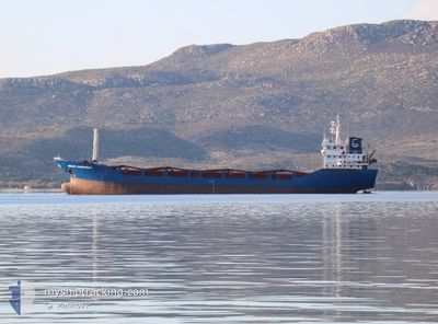
General Cargo
Current Trip
| Time Travelled | 23 h, 7 mins |
|---|---|
| Remaining Time | 17 h, 17 mins |
| Distance Travelled | 197.51 nm |
| Remaining Distance | 190.31 nm |
| AVG Speed | 9.1 Noeuds |
| MAX Speed | 10.7 Noeuds |
| AVG Wind | 5.9 knots |
| MAX Wind | 17 knots |
| MIN Temp | 4.7°C / 40.46°F |
| MAX Temp | 11.8°C / 53.24°F |
| Tirant d eau | 3.5 m |
| Position reçue | 3 m depuis |
Current Position
| Longitude | --- |
|---|---|
| Latitude | --- |
| Etat | At anchor |
| Vitesse | |
| Parcours | 269° |
| Zone | Sea of Marmara |
| Station | T-AIS |
| Position reçue | 3 m depuis |
Info
Information
The current position of NECATI CAVUSOGLU is in Sea of Marmara with coordinates 40.96385° / 28.89634° as reported on 2025-12-10 11:05 by AIS to our vessel tracker app. The vessel's current speed is 0 Noeuds and is heading at the port of CONSTANTA. The estimated time of arrival as calculated by MyShipTracking vessel tracking app is 2025-12-11 06:25 LT
The vessel NECATI CAVUSOGLU (IMO: 9212785, MMSI: 314640000) is a General Cargo that was built in 1999 ( 26 Age ). It's sailing under the flag of [BB] Barbados.
In this page you can find informations about the vessels current position, last detected port calls, and current voyage information. If the vessels is not in coverage by AIS you will find the latest position.
The current position of NECATI CAVUSOGLU is detected by our AIS receivers and we are not responsible for the reliability of the data. The last position was recorded while the vessel was in Coverage by the Ais receivers of our vessel tracking app.
The current draught of NECATI CAVUSOGLU as reported by AIS is 3.5 meters
Weather
| Temperature | 10.7°C / 51.26°F |
|---|---|
| Wind Speed | 4 knots |
| Direction | 250° WSW |
| Pressure | 1021.3 hPa |
| Humidity | 66.2 % |
| Cloud Coverage | 100 % |
Featured Company
Last Port Calls
| Port | Arrival | Departure | Time In Port |
|---|---|---|---|
| 2025-12-04 07:52 | 2025-12-09 14:01 | 5 d | |
| 2025-11-24 09:12 | 2025-11-25 18:31 | 1 d | |
| 2025-11-14 18:48 | 2025-11-16 06:00 | 1 d | |
| 2025-10-30 08:25 | 2025-11-03 14:34 | 4 d | |
| 2025-10-25 08:28 | 2025-10-28 18:17 | 3 d | |
| 2025-10-22 06:41 | 2025-10-24 07:58 | 2 d | |
| 2025-10-17 12:40 | 2025-10-18 22:19 | 1 d | |
| 2025-10-13 06:19 | 2025-10-14 18:09 | 1 d | |
| 2025-10-01 08:32 | 2025-10-04 09:39 | 3 d |
Last Trips
| Origin | Departure | Destination | Arrival | Distance | |
|---|---|---|---|---|---|
| 2025-11-25 18:31 | 2025-12-04 07:52 | 1369.04 nm | |||
| 2025-11-16 06:00 | 2025-11-24 09:12 | 431.82 nm | |||
| 2025-11-03 14:34 | 2025-11-14 18:48 | 1457.58 nm | |||
| 2025-10-28 18:17 | 2025-10-30 08:25 | 216.06 nm | |||
| 2025-10-24 07:58 | 2025-10-25 08:28 | 234.29 nm | |||
| 2025-10-18 22:19 | 2025-10-22 06:41 | 709.89 nm | |||
| 2025-10-14 18:09 | 2025-10-17 12:40 | 235.01 nm | |||
| 2025-10-04 09:39 | 2025-10-13 06:19 | 972.27 nm | |||
| 2025-09-30 18:00 | 2025-10-01 08:32 | 120.85 nm |
Events
| Heure | Evenement | Détails | Position/ Destination | Info |
|---|---|---|---|---|
| 2025-12-10 08:26 | Arret | 0.92 nm, South of ZEYTINBURNU |
40.96392 / 28.89633
RO CND
|
Vitesse: 0.3 kn Parcours: 247° |
| 2025-12-10 08:23 | Etat Changé | At anchor Under way using engine |
40.96358 / 28.89621
RO CND
|
Vitesse: 0.9 kn Parcours: 306° |
| 2025-12-10 04:19 | Etat Changé | Under way using engine Default |
40.78158 / 28.20052
RO CND
|
Vitesse: 10 kn Parcours: 82° |
| 2025-12-10 04:15 | Etat Changé | Default Under way using engine |
40.78043 / 28.18754
RO CND
|
Vitesse: 10 kn Parcours: 82.1° |
| 2025-12-10 03:28 | Etat Changé | Under way using engine Default |
40.76114 / 28.01715
RO CND
|
Vitesse: 9.9 kn Parcours: 83° |
| 2025-12-10 03:25 | Etat Changé | Default Under way using engine |
40.76020 / 28.00624
RO CND
|
Vitesse: 10 kn Parcours: 80.2° |
| 2025-12-10 02:22 | Etat Changé | Under way using engine Default |
40.73674 / 27.77689
RO CND
|
Vitesse: 10 kn Parcours: 83° |
| 2025-12-10 02:17 | Etat Changé | Default Under way using engine |
40.73496 / 27.75748
RO CND
|
Vitesse: 9.9 kn Parcours: 81° |
| 2025-12-10 02:10 | Etat Changé | Under way using engine Default |
40.73256 / 27.73211
RO CND
|
Vitesse: 9.9 kn Parcours: 82° |
| 2025-12-10 02:01 | Dans la zone couverte |
40.73256 / 27.73211
Sea of Marmara
RO CND
|
Vitesse: 9.9 kn Parcours: 83.4° |