
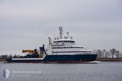
N-SEA PATHFINDER
Diving Support Vessel
Current Trip
| Time Travelled | 5 days |
|---|---|
| Remaining Time | --- |
| Distance Travelled | 500.68 nm |
| Remaining Distance | --- |
| AVG Speed | 9 Noeuds |
| MAX Speed | 12.8 Noeuds |
| AVG Wind | 19.8 knots |
| MAX Wind | 31.8 knots |
| MIN Temp | 7.2°C / 44.96°F |
| MAX Temp | 12.4°C / 54.32°F |
| Tirant d eau | 3.5 m |
| Position reçue | 2 m depuis |
Current Position
| Longitude | --- |
|---|---|
| Latitude | --- |
| Etat | Under way using engine |
| Vitesse | |
| Parcours | 81° |
| Zone | North Sea |
| Station | T-AIS |
| Position reçue | 2 m depuis |
Info
Information
The current position of N-SEA PATHFINDER is in North Sea with coordinates 57.13528° / -2.05595° as reported on 2025-12-05 19:17 by AIS to our vessel tracker app. The vessel's current speed is 0 Noeuds
The vessel N-SEA PATHFINDER (IMO: 9545663, MMSI: 245457000) is a Diving Support Vessel that was built in 2010 ( 15 Age ). It's sailing under the flag of [NL] Netherlands.
In this page you can find informations about the vessels current position, last detected port calls, and current voyage information. If the vessels is not in coverage by AIS you will find the latest position.
The current position of N-SEA PATHFINDER is detected by our AIS receivers and we are not responsible for the reliability of the data. The last position was recorded while the vessel was in Coverage by the Ais receivers of our vessel tracking app.
The current draught of N-SEA PATHFINDER as reported by AIS is 3.5 meters
Weather
| Temperature | 8.6°C / 47.48°F |
|---|---|
| Wind Speed | 29 knots |
| Direction | 149° SSE |
| Pressure | 993.9 hPa |
| Humidity | 86.4 % |
| Cloud Coverage | 100 % |
Featured Company
Last Port Calls
| Port | Arrival | Departure | Time In Port |
|---|---|---|---|
| 2025-11-24 08:42 | 2025-11-30 17:16 | 6 d | |
| 2025-11-24 07:34 | 2025-11-24 08:28 | 53 m | |
| 2025-10-03 19:44 | 2025-10-11 08:10 | 7 d | |
| 2025-10-03 01:15 | 2025-10-03 19:35 | 18 h | |
| 2025-10-01 21:37 | 2025-10-02 00:34 | 2 h | |
| 2025-10-01 13:59 | 2025-10-01 14:57 | 57 m |
Most Visited Ports (Last year)
| Port | Arrivals | |
|---|---|---|
| 12 | ||
| 9 | ||
| 6 | ||
| 5 | ||
| 3 | ||
| 3 |
Last Trips
| Origin | Departure | Destination | Arrival | Distance | |
|---|---|---|---|---|---|
| 2025-11-24 08:28 | 2025-11-24 08:42 | 1.30 nm | |||
| 2025-10-11 08:10 | 2025-11-24 07:34 | 1185.24 nm | |||
| 2025-10-03 19:35 | 2025-10-03 19:44 | 1.15 nm | |||
| 2025-10-02 00:34 | 2025-10-03 01:15 | 48.67 nm | |||
| 2025-10-01 14:57 | 2025-10-01 21:37 | 40.49 nm | |||
| 2025-09-29 14:03 | 2025-10-01 13:59 | 41.15 nm |
Events
| Heure | Evenement | Détails | Position/ Destination | Info |
|---|---|---|---|---|
| 2025-12-04 06:49 | Arret | 0.83 nm, South East of ABERDEEN |
57.13433 / -2.05513
ABERDEEN
|
Vitesse: 0.1 kn Parcours: 39° |
| 2025-12-04 06:13 | Changement de destination | ABERDEEN OWF INCHCAPE |
57.10013 / -2.00987
ABERDEEN
|
Vitesse: 8.2 kn Parcours: 1° |
| 2025-12-04 06:13 | Changement d'ETA | 2025/12/04 07:00 2025/12/03 15:00 |
57.10013 / -2.00987
ABERDEEN
|
Vitesse: 8.2 kn Parcours: 1° |
| 2025-12-04 03:35 | Dans la zone couverte |
56.75661 / -2.16477
North Sea
|
Vitesse: 9 kn Parcours: 21.4° |
|
| 2025-12-04 02:00 | Hors de la zone couverte |
56.54986 / -2.22605
North Sea
|
Vitesse: 0.7 kn Parcours: 32.8° |
|
| 2025-12-04 02:00 | Dans la zone couverte |
56.54986 / -2.22605
North Sea
|
Vitesse: 0.7 kn Parcours: 32.8° |
|
| 2025-12-03 12:57 | Hors de la zone couverte |
56.89661 / -2.07173
North Sea
OWF INCHCAPE
|
Vitesse: 9 kn Parcours: 202.1° |
|
| 2025-12-03 11:17 | Démarrage | 0.89 nm, South East of ABERDEEN |
57.13265 / -2.05505
OWF INCHCAPE
|
Vitesse: 5.4 kn Parcours: 182.5° |
| 2025-12-03 11:04 | Etat Changé | Under way using engine Moored |
57.13525 / -2.05637
OWF INCHCAPE
|
Vitesse: Parcours: 262° |
| 2025-12-03 10:43 | Changement de destination | OWF INCHCAPE GB ABD |
57.13528 / -2.05632
OWF INCHCAPE
|
Vitesse: 0.1 kn Parcours: 262° |