
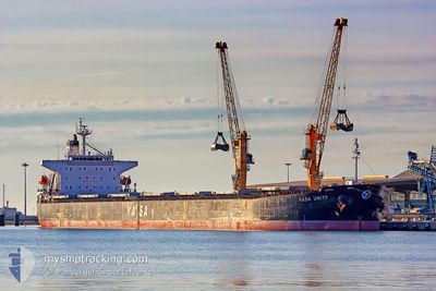
MV YASA UNITY
Bulk Carrier
Current Trip
| Time Travelled | 8 h, 18 mins |
|---|---|
| Remaining Time | --- |
| Distance Travelled | 65.10 nm |
| Remaining Distance | --- |
| AVG Speed | 9.1 Noeuds |
| MAX Speed | 11.6 Noeuds |
| AVG Wind | 18.4 knots |
| MAX Wind | 22.3 knots |
| MIN Temp | 20.4°C / 68.72°F |
| MAX Temp | 21.3°C / 70.34°F |
| Tirant d eau | 6.7 m |
| Position reçue | 20 d depuis |
Current Position
| Longitude | --- |
|---|---|
| Latitude | --- |
| Etat | Under way using engine |
| Vitesse | 12.2 Noeuds |
| Parcours | 47° |
| Zone | Singapore Strait |
| Station | T-AIS |
| Position reçue | 20 d depuis |
Info
Information
The current position of MV YASA UNITY is in Singapore Strait with coordinates 1.29250° / 104.33907° as reported on 2025-11-30 14:38 by AIS to our vessel tracker app. The vessel's current speed is 12.2 Noeuds and is heading at the port of MUARA.
The vessel MV YASA UNITY (IMO: 9296262, MMSI: 538002548) is a Bulk Carrier that was built in 2006 ( 19 Age ). It's sailing under the flag of [MH] Marshall Is.
In this page you can find informations about the vessels current position, last detected port calls, and current voyage information. If the vessels is not in coverage by AIS you will find the latest position.
The current position of MV YASA UNITY is detected by our AIS receivers and we are not responsible for the reliability of the data. The last position was recorded while the vessel was in Coverage by the Ais receivers of our vessel tracking app.
The current draught of MV YASA UNITY as reported by AIS is 6.7 meters
Weather
| Temperature | 20.7°C / 69.26°F |
|---|---|
| Wind Speed | 21 knots |
| Direction | 73° ENE |
| Pressure | 1018.2 hPa |
| Humidity | 81.6 % |
| Cloud Coverage | --- |
Featured Company
Last Port Calls
| Port | Arrival | Departure | Time In Port |
|---|---|---|---|
| 2025-12-19 13:10 | 2025-12-21 11:26 | 1 d | |
| 2025-11-20 23:22 | 2025-11-22 15:31 | 1 d | |
| 2025-11-03 02:59 | 2025-11-04 13:43 | 1 d | |
| 2025-10-11 23:13 | 2025-10-13 14:10 | 1 d | |
| 2025-10-05 10:36 | 2025-10-07 19:34 | 2 d |
Last Trips
| Origin | Departure | Destination | Arrival | Distance | |
|---|---|---|---|---|---|
| 2025-11-22 15:31 | 2025-12-19 13:10 | 4021.23 nm | |||
| 2025-11-04 13:43 | 2025-11-20 23:22 | 3812.52 nm | |||
| 2025-10-13 14:10 | 2025-11-03 02:59 | 4567.35 nm | |||
| 2025-10-07 19:34 | 2025-10-11 23:13 | 1063.98 nm | |||
| 2025-09-20 08:03 | 2025-10-05 10:36 | 3661.38 nm |
Events
| Heure | Evenement | Détails | Position/ Destination | Info |
|---|---|---|---|---|
| 2025-12-21 03:26 | PORT DE DEPART |
|
21.90182 / 113.21085
MUARA BANYUASIN
|
Vitesse: 9 kn Parcours: 162° |
| 2025-12-21 03:02 | Démarrage |
21.94860 / 113.20194
[CN] ZHUHAI
|
Vitesse: 3.3 kn Parcours: 220° |
|
| 2025-12-19 05:14 | Arret |
21.94853 / 113.20641
[CN] ZHUHAI
|
Vitesse: Parcours: 39° |
|
| 2025-12-19 05:10 | Port d'arrivée |
|
21.94863 / 113.20617
[CN] ZHUHAI
|
Vitesse: 3 kn Parcours: 67° |
| 2025-12-12 17:27 | Démarrage |
-.70317 / 105.54140
MUARA BANYUASIN
|
Vitesse: 3.8 kn Parcours: 24° |
|
| 2025-12-12 16:35 | Arret |
-.70338 / 105.53120
MUARA BANYUASIN
|
Vitesse: 0.3 kn Parcours: 61° |
|
| 2025-12-12 06:32 | Démarrage | 11.3 nm, West of MENTOK |
-2.02390 / 104.98080
MUARA BANYUASIN
|
Vitesse: 3.8 kn Parcours: 40° |