
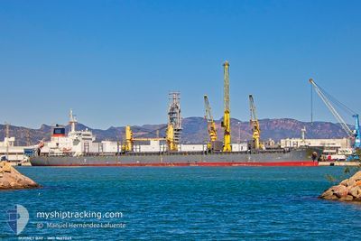
GURNET BAY
Not available
Current Trip
| Time Travelled | 11 days |
|---|---|
| Remaining Time | --- |
| Distance Travelled | 2834.60 nm |
| Remaining Distance | --- |
| AVG Speed | 11.2 Noeuds |
| MAX Speed | 13 Noeuds |
| AVG Wind | 11.2 knots |
| MAX Wind | 25 knots |
| MIN Temp | 12.5°C / 54.5°F |
| MAX Temp | 19°C / 66.2°F |
| Tirant d eau | 9.4 m |
| Position reçue | 3 d depuis |
Current Position
| Longitude | --- |
|---|---|
| Latitude | --- |
| Etat | Under way using engine |
| Vitesse | 11.6 Noeuds |
| Parcours | 268.1° |
| Zone | North Atlantic Ocean |
| Station | T-AIS |
| Position reçue | 3 d depuis |
Info
Information
The current position of GURNET BAY is in North Atlantic Ocean with coordinates 35.95521° / -6.07589° as reported on 2025-12-17 20:25 by AIS to our vessel tracker app. The vessel's current speed is 11.6 Noeuds and is heading at the port of CAP HAITIEN. The estimated time of arrival as calculated by MyShipTracking vessel tracking app is 2025-12-29 18:00 LT
The vessel GURNET BAY (IMO: 9667045, MMSI: 255806204) is a Not available It's sailing under the flag of [PT] Portugal.
In this page you can find informations about the vessels current position, last detected port calls, and current voyage information. If the vessels is not in coverage by AIS you will find the latest position.
The current position of GURNET BAY is detected by our AIS receivers and we are not responsible for the reliability of the data. The last position was recorded while the vessel was in Coverage by the Ais receivers of our vessel tracking app.
The current draught of GURNET BAY as reported by AIS is 9.4 meters
Weather
| Temperature | 18.7°C / 65.66°F |
|---|---|
| Wind Speed | 11 knots |
| Direction | 25° NNE |
| Pressure | 1025.9 hPa |
| Humidity | 65.1 % |
| Cloud Coverage | 80 % |
Featured Company
Last Trips
| Origin | Departure | Destination | Arrival | Distance | |
|---|---|---|---|---|---|
| 2025-11-30 06:23 | 2025-12-02 13:09 | 570.87 nm | |||
| 2025-11-08 16:00 | 2025-11-24 17:44 | 4476.84 nm | |||
| 2025-10-28 22:09 | 2025-11-02 15:44 | 1263.22 nm | |||
| 2025-10-28 18:42 | 2025-10-28 20:16 | 8.58 nm | |||
| 2025-09-29 21:54 | 2025-10-12 10:21 | 3289.66 nm |
Events
| Heure | Evenement | Détails | Position/ Destination | Info |
|---|---|---|---|---|
| 2025-12-17 20:30 | Etat Changé | Default Under way using engine |
35.95334 / -6.09333
CAP HAITIEN HTCAP
|
Vitesse: 11.6 kn Parcours: 268.1° |
| 2025-12-17 20:25 | Hors de la zone couverte |
35.95521 / -6.07589
North Atlantic Ocean
CAP HAITIEN HTCAP
|
Vitesse: 11.6 kn Parcours: 268.1° |
|
| 2025-12-17 19:58 | Changement de zone | Moroccan part of the North Atlantic Ocean Moroccan part of the Strait of Gibraltar |
35.95656 / -5.96936
North Atlantic Ocean
CAP HAITIEN HTCAP
|
Vitesse: 11.6 kn Parcours: 270.5° |
| 2025-12-17 19:54 | Changement de zone | Moroccan part of the Strait of Gibraltar Spanish part of the Strait of Gibraltar |
35.95640 / -5.95352
Strait of Gibraltar
CAP HAITIEN HTCAP
|
Vitesse: 11.8 kn Parcours: 270.4° |
| 2025-12-17 18:35 | Changement d'ETA | 2025/12/29 23:00 |
35.96059 / -5.64655
CAP HAITIEN HTCAP
|
Vitesse: 10.5 kn Parcours: 275° |
| 2025-12-17 17:29 | Changement d'ETA | 2025/12/29 23:00 |
36.00378 / -5.42561
CAP HAITIEN HTCAP
|
Vitesse: 11.3 kn Parcours: 254.8° |
| 2025-12-17 17:10 | Changement de zone | Spanish part of the Strait of Gibraltar Gibraltarian part of the Strait of Gibraltar |
36.02130 / -5.35201
Strait of Gibraltar
|
Vitesse: 11.9 kn Parcours: 252° |
| 2025-12-17 17:06 | Changement de zone | Gibraltarian part of the Strait of Gibraltar Gibraltarian part of the Alboran Sea |
36.02473 / -5.33838
Strait of Gibraltar
|
Vitesse: 12 kn Parcours: 253.9° |
| 2025-12-17 15:59 | Changement d'ETA | 2025/12/29 23:00 2025/12/30 18:00 |
36.06959 / -5.05804
CAP HAITIEN HTCAP
|
Vitesse: 12.4 kn Parcours: 261.9° |
| 2025-12-17 15:30 | Detecté en mer | Gibraltarian part of the Alboran Sea |
36.08533 / -4.93898
Alboran Sea
CAP HAITIEN HTCAP
|
Vitesse: 12.2 kn Parcours: 259.7° |