
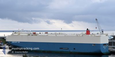
MERCURY ACE
Vehicles Carrier
Current Trip
| Time Travelled | 8 days |
|---|---|
| Remaining Time | 6 h, 11 mins |
| Distance Travelled | 3849.83 nm |
| Remaining Distance | 91.43 nm |
| AVG Speed | 17.7 Noeuds |
| MAX Speed | 20.2 Noeuds |
| AVG Wind | 8.7 knots |
| MAX Wind | 18.5 knots |
| MIN Temp | 16.4°C / 61.52°F |
| MAX Temp | 29°C / 84.2°F |
| Tirant d eau | 8.2 m |
| Position reçue | 2 h, 21 m depuis |
Current Position
| Longitude | --- |
|---|---|
| Latitude | --- |
| Etat | Under way using engine |
| Vitesse | 14.2 Noeuds |
| Parcours | 131.2° |
| Zone | Malacca Strait |
| Station | T-AIS |
| Position reçue | 2 h, 21 m depuis |
Info
Information
The current position of MERCURY ACE is in Malacca Strait with coordinates 1.93931° / 102.16777° as reported on 2026-01-04 17:30 by AIS to our vessel tracker app. The vessel's current speed is 14.2 Noeuds and is heading at the port of SINGAPORE. The estimated time of arrival as calculated by MyShipTracking vessel tracking app is 2026-01-05 10:02 LT
The vessel MERCURY ACE (IMO: 9591052, MMSI: 370644000) is a Vehicles Carrier that was built in 2011 ( 15 Age ). It's sailing under the flag of [PA] Panama.
In this page you can find informations about the vessels current position, last detected port calls, and current voyage information. If the vessels is not in coverage by AIS you will find the latest position.
The current position of MERCURY ACE is detected by our AIS receivers and we are not responsible for the reliability of the data. The last position was recorded while the vessel was in Coverage by the Ais receivers of our vessel tracking app.
The current draught of MERCURY ACE as reported by AIS is 8.2 meters
Weather
| Temperature | 25.7°C / 78.26°F |
|---|---|
| Wind Speed | 15 knots |
| Direction | 34° NE |
| Pressure | 1010.8 hPa |
| Humidity | 78.5 % |
| Cloud Coverage | 63 % |
Featured Company
Last Port Calls
| Port | Arrival | Departure | Time In Port |
|---|---|---|---|
| 2025-12-26 11:49 | 2025-12-27 02:52 | 15 h | |
| 2025-12-25 09:29 | 2025-12-25 16:57 | 7 h | |
| 2025-12-24 08:08 | 2025-12-25 00:59 | 16 h | |
| 2025-12-17 17:12 | 2025-12-20 07:17 | 2 d | |
| 2025-12-15 14:52 | 2025-12-16 08:58 | 18 h | |
| 2025-12-07 05:43 | 2025-12-08 22:04 | 1 d | |
| 2025-12-03 07:22 | 2025-12-06 09:38 | 3 d | |
| 2025-12-01 07:56 | 2025-12-02 03:11 | 19 h | |
| 2025-11-26 12:19 | 2025-11-27 07:28 | 19 h | |
| 2025-11-09 16:09 | 2025-11-10 08:22 | 16 h |
Most Visited Ports (Last year)
| Port | Arrivals | |
|---|---|---|
| 3 | ||
| 3 | ||
| 3 | ||
| 2 | ||
| 2 | ||
| 2 |
Last Trips
| Origin | Departure | Destination | Arrival | Distance | |
|---|---|---|---|---|---|
| 2025-12-25 16:57 | 2025-12-26 11:49 | 303.97 nm | |||
| 2025-12-25 00:59 | 2025-12-25 09:29 | 104.01 nm | |||
| 2025-12-20 07:17 | 2025-12-24 08:08 | 577.69 nm | |||
| 2025-12-16 08:58 | 2025-12-17 17:12 | 300.00 nm | |||
| 2025-12-08 22:04 | 2025-12-15 14:52 | 2847.25 nm | |||
| 2025-12-06 09:38 | 2025-12-07 05:43 | 158.30 nm | |||
| 2025-12-02 03:11 | 2025-12-03 07:22 | 156.07 nm | |||
| 2025-11-27 07:28 | 2025-12-01 07:56 | 1569.88 nm | |||
| 2025-11-10 08:22 | 2025-11-26 12:19 | 6069.63 nm | |||
| 2025-11-06 20:39 | 2025-11-09 16:09 | 914.73 nm |
Events
| Heure | Evenement | Détails | Position/ Destination | Info |
|---|---|---|---|---|
| 2026-01-04 17:37 | Etat Changé | Default Under way using engine |
1.92248 / 102.18855
SG SIN
|
Vitesse: 14.2 kn Parcours: 131.2° |
| 2026-01-04 17:30 | Hors de la zone couverte |
1.93931 / 102.16777
Malacca Strait
SG SIN
|
Vitesse: 14.2 kn Parcours: 131.2° |
|
| 2026-01-04 16:56 | Tirant d'eau modifié | 8.2 7.5 |
2.03083 / 102.06579
SG SIN
|
Vitesse: 14.8 kn Parcours: 132.2° |
| 2026-01-04 16:56 | Changement d'ETA | 2026/01/05 03:00 2026/01/05 02:00 |
2.03083 / 102.06579
SG SIN
|
Vitesse: 14.8 kn Parcours: 132.2° |
| 2026-01-04 16:32 | Changement de zone | Indonesian part of the Malacca Strait Malaysian part of the Malacca Strait |
2.09813 / 101.98599
Malacca Strait
SG SIN
|
Vitesse: 16.1 kn Parcours: 135.1° |
| 2026-01-04 16:10 | Changement de zone | Malaysian part of the Malacca Strait Indian part of the Laccadive Sea |
2.16711 / 101.91397
Malacca Strait
SG SIN
|
Vitesse: 16.4 kn Parcours: 130.7° |
| 2026-01-04 16:10 | Etat Changé | Under way using engine Default |
2.16711 / 101.91397
SG SIN
|
Vitesse: 16.5 kn Parcours: 131° |
| 2026-01-04 15:53 | Dans la zone couverte |
2.16711 / 101.91397
Malacca Strait
SG SIN
|
Vitesse: 16.4 kn Parcours: 130.7° |
|
| 2026-01-01 02:22 | Etat Changé | Default Under way using engine |
6.47757 / 77.91481
SG SIN
|
Vitesse: 19 kn Parcours: 135.7° |
| 2026-01-01 02:21 | Hors de la zone couverte |
6.47947 / 77.91298
Laccadive Sea
SG SIN
|
Vitesse: 19 kn Parcours: 135.7° |