
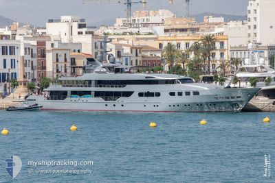
MAGNA GRECIA
Yacht
Current Trip
| Trip Time | 10 h, 37 mins |
|---|---|
| Trip Distance | 81.95 nm |
| AVG Speed | 11 Noeuds |
| MAX Speed | 13.1 Noeuds |
| Tirant d eau | 3.8 m |
| AVG Wind | 3.8 knots |
| MAX Wind | 5 knots |
| MIN Temp | 23.4°C / 74.12°F |
| MAX Temp | 30.9°C / 87.62°F |
| Position reçue | 3 m depuis |
Current Position
| Longitude | 23.68089° |
|---|---|
| Latitude | 37.93049° |
| Etat | Moored |
| Vitesse | |
| Parcours | 61° |
| Zone | Aegean Sea |
| Station | T-AIS |
| Position reçue | 3 m depuis |
Info
Information
The current position of MAGNA GRECIA is in Aegean Sea with coordinates 37.93049° / 23.68089° as reported on 2024-06-08 08:42 by AIS to our vessel tracker app. The vessel's current speed is 0 Noeuds and is currently inside the port of FLISVOS.
The vessel MAGNA GRECIA (IMO: 1003085, MMSI: 538071082) is a Yacht that was built in 1986 ( 38 Age ). It's sailing under the flag of [MH] Marshall Is.
In this page you can find informations about the vessels current position, last detected port calls, and current voyage information. If the vessels is not in coverage by AIS you will find the latest position.
The current position of MAGNA GRECIA is detected by our AIS receivers and we are not responsible for the reliability of the data. The last position was recorded while the vessel was in Coverage by the Ais receivers of our vessel tracking app.
The current draught of MAGNA GRECIA as reported by AIS is 3.8 meters
Weather
| Temperature | 29.9°C / 85.82°F |
|---|---|
| Wind Speed | 11 knots |
| Direction | 9° N |
| Pressure | 1012.1 hPa |
| Humidity | 33.6 % |
| Cloud Coverage | --- |
Featured Company
Events
| Heure | Evenement | Détails | Position/ Destination | Info |
|---|---|---|---|---|
| 2024-06-06 16:23 | Etat Changé | Moored Under way using engine |
37.93047 / 23.68089
[GR] FLISVOS
|
Vitesse: Parcours: 63° |
| 2024-06-06 16:09 | Arret |
37.93144 / 23.68196
[GR] FLISVOS
|
Vitesse: 0.3 kn Parcours: 61° |
|
| 2024-06-06 16:04 | Port d'arrivée |
|
37.93508 / 23.67945
[GR] FLISVOS
|
Vitesse: 4.1 kn Parcours: 111° |
| 2024-06-06 16:03 | Démarrage | 0.21 nm, West of FLISVOS |
37.93530 / 23.67875
FLISVOS
|
Vitesse: 4.1 kn Parcours: 111° |
| 2024-06-06 15:53 | Arret | 0.31 nm, West of FLISVOS |
37.93478 / 23.67650
FLISVOS
|
Vitesse: 0.3 kn Parcours: 28° |
| 2024-06-06 15:07 | Changement de destination | FLISVOS INTWATERS |
37.79302 / 23.71972
FLISVOS
|
Vitesse: 12.9 kn Parcours: 335.9° |
| 2024-06-06 15:07 | Changement d'ETA | 2024/06/06 19:00 2024/06/06 12:00 |
37.79302 / 23.71972
FLISVOS
|
Vitesse: 12.9 kn Parcours: 335.9° |
| 2024-06-06 14:44 | Dans la zone couverte |
37.71867 / 23.76282
Aegean Sea
INTWATERS
|
Vitesse: 12.8 kn Parcours: 336.3° |
|
| 2024-06-06 09:20 | Hors de la zone couverte |
37.27109 / 23.80189
Aegean Sea
INTWATERS
|
Vitesse: 0.9 kn Parcours: 243.5° |
|
| 2024-06-06 09:14 | Dans la zone couverte |
37.27173 / 23.80324
Aegean Sea
INTWATERS
|
Vitesse: 0.8 kn Parcours: 235.9° |