
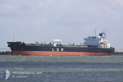
M/T RED DIAMOND
Oil/Chemical Tanker
Current Trip
| Time Travelled | 6 days |
|---|---|
| Remaining Time | --- |
| Distance Travelled | 2151.17 nm |
| Remaining Distance | --- |
| AVG Speed | 12.6 Noeuds |
| MAX Speed | 16.5 Noeuds |
| AVG Wind | 9.7 knots |
| MAX Wind | 33.7 knots |
| MIN Temp | 14.5°C / 58.1°F |
| MAX Temp | 20°C / 68°F |
| Tirant d eau | 9.1 m |
| Position reçue | 10 h, 24 m depuis |
Current Position
| Longitude | -8.50267° |
|---|---|
| Latitude | 45.19421° |
| Etat | Under way using engine |
| Vitesse | 13 Noeuds |
| Parcours | 28.4° |
| Zone | North Atlantic Ocean |
| Station | T-AIS |
| Position reçue | 10 h, 24 m depuis |
Info
Information
The current position of M/T RED DIAMOND is in North Atlantic Ocean with coordinates 45.19421° / -8.50267° as reported on 2024-05-11 03:23 by AIS to our vessel tracker app. The vessel's current speed is 13 Noeuds and is heading at the port of PORT JEROME. The estimated time of arrival as calculated by MyShipTracking vessel tracking app is 2024-05-12 17:00 LT
The vessel M/T RED DIAMOND (IMO: 9583665, MMSI: 256480000) is a Oil/Chemical Tanker that was built in 2012 ( 12 Age ). It's sailing under the flag of [MT] Malta.
In this page you can find informations about the vessels current position, last detected port calls, and current voyage information. If the vessels is not in coverage by AIS you will find the latest position.
The current position of M/T RED DIAMOND is detected by our AIS receivers and we are not responsible for the reliability of the data. The last position was recorded while the vessel was in Coverage by the Ais receivers of our vessel tracking app.
The current draught of M/T RED DIAMOND as reported by AIS is 9.1 meters
Weather
| Temperature | 15.4°C / 59.72°F |
|---|---|
| Wind Speed | 4 knots |
| Direction | 95° E |
| Pressure | 1015.5 hPa |
| Humidity | 92.6 % |
| Cloud Coverage | 7 % |
Featured Company
Last Port Calls
| Port | Arrival | Departure | Time In Port |
|---|---|---|---|
| 2024-05-04 07:28 | 2024-05-04 18:28 | 11 h | |
| 2024-05-02 08:35 | 2024-05-03 18:49 | 1 d | |
| 2024-04-29 19:14 | 2024-05-01 09:26 | 1 d | |
| 2024-04-26 01:10 | 2024-04-26 03:28 | 2 h | |
| 2024-04-06 22:03 | 2024-04-09 19:49 | 2 d | |
| 2024-03-28 23:05 | 2024-03-31 17:46 | 2 d | |
| 2024-03-09 17:14 | 2024-03-13 18:02 | 4 d | |
| 2024-03-06 04:23 | 2024-03-08 17:52 | 2 d |
Last Trips
| Origin | Departure | Destination | Arrival | Distance | |
|---|---|---|---|---|---|
| 2024-05-03 20:49 | 2024-05-04 09:28 | 4.09 nm | |||
| 2024-05-01 11:26 | 2024-05-02 10:35 | 5.04 nm | |||
| 2024-04-26 06:28 | 2024-04-29 21:14 | 1004.27 nm | |||
| 2024-04-09 21:49 | 2024-04-26 04:10 | 2507.50 nm | |||
| 2024-03-31 19:46 | 2024-04-07 00:03 | 1457.81 nm | |||
| 2024-03-13 19:02 | 2024-03-29 00:05 | 193.92 nm | |||
| 2024-03-08 18:52 | 2024-03-09 18:14 | 260.31 nm | |||
| 2024-02-27 04:25 | 2024-03-06 05:23 | 294.77 nm |
Events
| Heure | Evenement | Détails | Position/ Destination | Info |
|---|---|---|---|---|
| 2024-05-11 03:30 | Etat Changé | Default Under way using engine |
45.21333 / -8.48667
ITTAR>FRPJE
|
Vitesse: 13 kn Parcours: 28.4° |
| 2024-05-11 03:23 | Etat Changé | Under way using engine Default |
45.19421 / -8.50267
ITTAR>FRPJE
|
Vitesse: 13 kn Parcours: 27° |
| 2024-05-11 03:23 | Hors de la zone couverte |
45.19421 / -8.50267
North Atlantic Ocean
ITTAR>FRPJE
|
Vitesse: 13 kn Parcours: 28.4° |
|
| 2024-05-11 03:18 | Dans la zone couverte |
45.19421 / -8.50267
North Atlantic Ocean
ITTAR>FRPJE
|
Vitesse: 13 kn Parcours: 28.4° |
|
| 2024-05-10 21:18 | Etat Changé | Default Under way using engine |
44.01145 / -9.38597
ITTAR>FRPJE
|
Vitesse: 13.1 kn Parcours: 28.4° |
| 2024-05-10 21:11 | Hors de la zone couverte |
43.98911 / -9.40276
North Atlantic Ocean
ITTAR>FRPJE
|
Vitesse: 13.1 kn Parcours: 28.4° |
|
| 2024-05-10 20:53 | Etat Changé | Under way using engine Default |
43.93170 / -9.44525
ITTAR>FRPJE
|
Vitesse: 13 kn Parcours: 31° |
| 2024-05-10 20:46 | Etat Changé | Default Under way using engine |
43.91073 / -9.46114
ITTAR>FRPJE
|
Vitesse: 12.8 kn Parcours: 29.3° |
| 2024-05-10 13:07 | Etat Changé | Under way using engine Default |
42.36128 / -9.94820
ITTAR>FRPJE
|
Vitesse: 12.4 kn Parcours: 6° |
| 2024-05-10 13:02 | Etat Changé | Default Under way using engine |
42.34455 / -9.94902
ITTAR>FRPJE
|
Vitesse: 12.6 kn Parcours: 0.5° |