
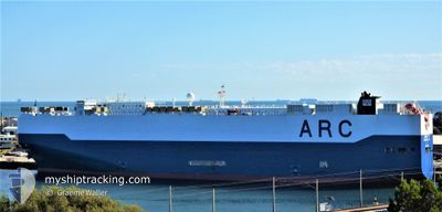
LIBERTY
Vehicles Carrier
Current Trip
| Time Travelled | 6 days |
|---|---|
| Remaining Time | --- |
| Distance Travelled | 2470.08 nm |
| Remaining Distance | --- |
| AVG Speed | 13.5 Noeuds |
| MAX Speed | 18 Noeuds |
| AVG Wind | 12.5 knots |
| MAX Wind | 24 knots |
| MIN Temp | 26°C / 78.8°F |
| MAX Temp | 30.1°C / 86.18°F |
| Tirant d eau | 8.6 m |
| Position reçue | 3 d depuis |
Current Position
| Longitude | -61.25864° |
|---|---|
| Latitude | 13.52694° |
| Etat | Under way using engine |
| Vitesse | 17.2 Noeuds |
| Parcours | 86.6° |
| Zone | Caribbean Sea |
| Station | T-AIS |
| Position reçue | 3 d depuis |
Info
Information
The current position of LIBERTY is in Caribbean Sea with coordinates 13.52694° / -61.25864° as reported on 2024-06-04 16:20 by AIS to our vessel tracker app. The vessel's current speed is 17.2 Noeuds and is heading at the port of RIO DE JANEIRO. The estimated time of arrival as calculated by MyShipTracking vessel tracking app is 2024-06-14 09:00 LT
The vessel LIBERTY (IMO: 9310109, MMSI: 367125000) is a Vehicles Carrier that was built in 2006 ( 18 Age ). It's sailing under the flag of [US] USA.
In this page you can find informations about the vessels current position, last detected port calls, and current voyage information. If the vessels is not in coverage by AIS you will find the latest position.
The current position of LIBERTY is detected by our AIS receivers and we are not responsible for the reliability of the data. The last position was recorded while the vessel was in Coverage by the Ais receivers of our vessel tracking app.
The current draught of LIBERTY as reported by AIS is 8.6 meters
Weather
| Temperature | 28°C / 82.4°F |
|---|---|
| Wind Speed | 10 knots |
| Direction | 107° ESE |
| Pressure | 1014.6 hPa |
| Humidity | 73.8 % |
| Cloud Coverage | 20 % |
Featured Company
Last Port Calls
| Port | Arrival | Departure | Time In Port |
|---|---|---|---|
| 2024-05-31 12:59 | 2024-06-01 01:59 | 12 h | |
| 2024-05-26 08:24 | 2024-05-27 05:02 | 20 h | |
| 2024-05-24 01:58 | 2024-05-25 00:10 | 22 h | |
| 2024-05-21 21:11 | 2024-05-22 23:02 | 1 d | |
| 2024-05-18 19:59 | 2024-05-20 05:32 | 1 d | |
| 2024-05-13 02:04 | 2024-05-13 17:46 | 15 h | |
| 2024-05-13 02:00 | |||
| 2024-05-13 01:53 | |||
| 2024-05-13 01:34 | |||
| 2024-05-13 01:29 |
Most Visited Ports (Last year)
| Port | Arrivals | |
|---|---|---|
| 13 | ||
| 12 | ||
| 5 | ||
| 4 | ||
| 3 | ||
| 3 |
Last Trips
| Origin | Departure | Destination | Arrival | Distance | |
|---|---|---|---|---|---|
| 2024-05-27 00:02 | 2024-05-31 07:59 | 1588.14 nm | |||
| 2024-05-24 19:10 | 2024-05-26 03:24 | 477.52 nm | |||
| 2024-05-22 18:02 | 2024-05-23 20:58 | 239.19 nm | |||
| 2024-05-20 00:32 | 2024-05-21 16:11 | 640.07 nm | |||
| 2024-05-13 12:46 | 2024-05-18 14:59 | 1551.70 nm | |||
| 2024-05-01 22:53 | 2024-05-12 21:04 | 3331.94 nm | |||
| 2024-05-01 22:53 | 2024-05-12 21:00 | 3331.88 nm | |||
| 2024-05-01 22:53 | 2024-05-12 20:53 | 3331.81 nm | |||
| 2024-05-01 22:53 | 2024-05-12 20:34 | 3331.75 nm | |||
| 2024-05-01 22:53 | 2024-05-12 20:29 | 3331.68 nm |
Events
| Heure | Evenement | Détails | Position/ Destination | Info |
|---|---|---|---|---|
| 2024-06-04 16:25 | Etat Changé | Default Under way using engine |
13.52793 / -61.23167
COCTG>BRRIO
|
Vitesse: 17.2 kn Parcours: 86.6° |
| 2024-06-04 16:20 | Etat Changé | Under way using engine Default |
13.52694 / -61.25864
COCTG>BRRIO
|
Vitesse: 17 kn Parcours: 84° |
| 2024-06-04 16:20 | Hors de la zone couverte |
13.52694 / -61.25864
Caribbean Sea
COCTG>BRRIO
|
Vitesse: 17.2 kn Parcours: 86.6° |
|
| 2024-06-04 16:10 | Etat Changé | Default Under way using engine |
13.52234 / -61.30784
COCTG>BRRIO
|
Vitesse: 17 kn Parcours: 86° |
| 2024-06-04 15:33 | Changement de zone | Saint Vincent and the Grenadines part of the Caribbean Sea Venezuelan part of the Caribbean Sea |
13.50861 / -61.48512
Caribbean Sea
COCTG>BRRIO
|
Vitesse: 17 kn Parcours: 86° |
| 2024-06-04 15:30 | Etat Changé | Under way using engine Default |
13.50763 / -61.50326
COCTG>BRRIO
|
Vitesse: 17 kn Parcours: 87° |
| 2024-06-04 15:20 | Dans la zone couverte |
13.50861 / -61.48512
Caribbean Sea
COCTG>BRRIO
|
Vitesse: 17 kn Parcours: 86° |
|
| 2024-06-03 21:09 | Etat Changé | Default Under way using engine |
13.10896 / -66.56243
COCTG>BRRIO
|
Vitesse: 16.1 kn Parcours: 85.1° |
| 2024-06-03 21:01 | Hors de la zone couverte |
13.10640 / -66.59766
Caribbean Sea
COCTG>BRRIO
|
Vitesse: 16.1 kn Parcours: 85.1° |
|
| 2024-06-03 19:33 | Changement de zone | Venezuelan part of the Caribbean Sea Colombian part of the Caribbean Sea |
13.08296 / -66.99588
Caribbean Sea
COCTG>BRRIO
|
Vitesse: 15.8 kn Parcours: 86.3° |