
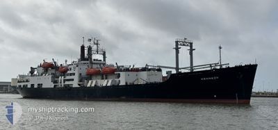
KENNEDY
Training Ship
Current Trip
| Time Travelled | 22 days |
|---|---|
| Remaining Time | --- |
| Distance Travelled | 2527.00 nm |
| Remaining Distance | 12.74 nm |
| AVG Speed | 8.9 Noeuds |
| MAX Speed | 14.5 Noeuds |
| AVG Wind | 11.1 knots |
| MAX Wind | 27.8 knots |
| MIN Temp | 24.1°C / 75.38°F |
| MAX Temp | 29.1°C / 84.38°F |
| Tirant d eau | 8.7 m |
| Position reçue | 2 d depuis |
Current Position
| Longitude | -94.74641° |
|---|---|
| Latitude | 29.34328° |
| Etat | Under way using engine |
| Vitesse | 12.8 Noeuds |
| Parcours | 84.9° |
| Zone | Gulf of Mexico |
| Station | T-AIS |
| Position reçue | 2 d depuis |
Info
Information
The current position of KENNEDY is in Gulf of Mexico with coordinates 29.34328° / -94.74641° as reported on 2024-06-02 20:03 by AIS to our vessel tracker app. The vessel's current speed is 12.8 Noeuds and is heading at the port of GALVESTON.
The vessel KENNEDY (IMO: 6621662, MMSI: 338919000) is a Training Ship that was built in 1967 ( 57 Age ). It's sailing under the flag of [US] USA.
In this page you can find informations about the vessels current position, last detected port calls, and current voyage information. If the vessels is not in coverage by AIS you will find the latest position.
The current position of KENNEDY is detected by our AIS receivers and we are not responsible for the reliability of the data. The last position was recorded while the vessel was in Coverage by the Ais receivers of our vessel tracking app.
The current draught of KENNEDY as reported by AIS is 8.7 meters
Weather
| Temperature | 28°C / 82.4°F |
|---|---|
| Wind Speed | 20 knots |
| Direction | 151° SSE |
| Pressure | 1006.8 hPa |
| Humidity | 86.8 % |
| Cloud Coverage | 53 % |
Featured Company
Last Port Calls
| Port | Arrival | Departure | Time In Port |
|---|---|---|---|
| 2024-05-11 08:20 | 2024-05-13 09:49 | 2 d | |
| 2024-05-04 08:22 | 2024-05-06 17:52 | 2 d | |
| 2024-04-20 14:26 |
Most Visited Ports (Last year)
| Port | Arrivals | |
|---|---|---|
| 1 | ||
| 1 | ||
| 1 | ||
| 1 | ||
| 1 | ||
| 1 |
Last Trips
| Origin | Departure | Destination | Arrival | Distance | |
|---|---|---|---|---|---|
| 2024-05-06 17:52 | 2024-05-11 08:20 | 1200.16 nm | |||
| 2024-04-20 14:26 | 2024-05-04 08:22 | 3093.76 nm |
Events
| Heure | Evenement | Détails | Position/ Destination | Info |
|---|---|---|---|---|
| 2024-06-03 18:01 | Arret | 10.37 nm, South East of GALVESTON |
29.17518 / -94.67129
GALVESTON TEXAS
|
Vitesse: 0.3 kn Parcours: 90° |
| 2024-06-02 20:08 | Etat Changé | Default Under way using engine |
29.34444 / -94.72570
GALVESTON TEXAS
|
Vitesse: 12.8 kn Parcours: 84.9° |
| 2024-06-02 20:03 | Hors de la zone couverte |
29.34328 / -94.74641
Gulf of Mexico
|
Vitesse: 12.8 kn Parcours: 84.9° |
|
| 2024-06-02 19:58 | Etat Changé | Under way using engine Default |
29.34166 / -94.76560
GALVESTON TEXAS
|
Vitesse: 11 kn Parcours: 34° |
| 2024-06-02 19:44 | Etat Changé | Default Under way using engine |
29.31547 / -94.78762
GALVESTON TEXAS
|
Vitesse: 5.8 kn Parcours: 90° |
| 2024-06-02 19:31 | Etat Changé | Under way using engine Default |
29.31041 / -94.81227
GALVESTON TEXAS
|
Vitesse: 2.2 kn Parcours: 96° |
| 2024-06-02 19:31 | Démarrage | 0.88 nm, West of GALVESTON |
29.31041 / -94.81227
GALVESTON TEXAS
|
Vitesse: 6.1 kn Parcours: 91.6° |
| 2024-06-02 19:15 | Etat Changé | Default Moored |
29.31262 / -94.81885
GALVESTON TEXAS
|
Vitesse: Parcours: 283° |
| 2024-06-02 19:09 | Etat Changé | Moored Default |
29.31267 / -94.81889
GALVESTON TEXAS
|
Vitesse: Parcours: 283° |
| 2024-06-02 19:06 | Etat Changé | Default Moored |
29.31268 / -94.81889
GALVESTON TEXAS
|
Vitesse: Parcours: 283° |