
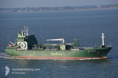
CHUKAR
Lpg Tanker
Current Trip
| Time Travelled | 15 days |
|---|---|
| Remaining Time | --- |
| Distance Travelled | 472.25 nm |
| Remaining Distance | --- |
| AVG Speed | 9.4 Noeuds |
| MAX Speed | 13.4 Noeuds |
| AVG Wind | 17.2 knots |
| MAX Wind | 35.8 knots |
| MIN Temp | 3.6°C / 38.48°F |
| MAX Temp | 15.3°C / 59.54°F |
| Tirant d eau | 5.2 m |
| Position reçue | 2 m depuis |
Current Position
| Longitude | -0.99503° |
|---|---|
| Latitude | 54.70630° |
| Etat | At anchor |
| Vitesse | 0.1 Noeuds |
| Parcours | 116° |
| Zone | North Sea |
| Station | T-AIS |
| Position reçue | 2 m depuis |
Info
Information
The current position of CHUKAR is in North Sea with coordinates 54.70630° / -0.99503° as reported on 2024-04-27 00:59 by AIS to our vessel tracker app. The vessel's current speed is 0.1 Noeuds
The vessel CHUKAR (IMO: 9578000, MMSI: 249362000) is a Lpg Tanker that was built in 2012 ( 12 Age ). It's sailing under the flag of [MT] Malta.
In this page you can find informations about the vessels current position, last detected port calls, and current voyage information. If the vessels is not in coverage by AIS you will find the latest position.
The current position of CHUKAR is detected by our AIS receivers and we are not responsible for the reliability of the data. The last position was recorded while the vessel was in Coverage by the Ais receivers of our vessel tracking app.
The current draught of CHUKAR as reported by AIS is 5.2 meters
Weather
| Temperature | 6.3°C / 43.34°F |
|---|---|
| Wind Speed | 5 knots |
| Direction | 90° E |
| Pressure | 1007.6 hPa |
| Humidity | 75 % |
| Cloud Coverage | 22 % |
Featured Company
Last Port Calls
| Port | Arrival | Departure | Time In Port |
|---|---|---|---|
| 2024-04-09 22:29 | 2024-04-11 21:31 | 1 d | |
| 2024-04-02 00:51 | 2024-04-02 23:04 | 22 h | |
| 2024-03-24 12:12 | 2024-03-25 13:39 | 1 d | |
| 2024-03-15 12:58 | 2024-03-17 12:41 | 1 d | |
| 2024-03-10 11:39 | 2024-03-14 11:56 | 4 d | |
| 2024-03-06 08:35 | 2024-03-07 11:04 | 1 d | |
| 2024-03-03 05:56 | 2024-03-04 06:27 | 1 d | |
| 2024-03-01 15:16 | 2024-03-02 15:48 | 1 d | |
| 2024-02-27 18:19 | 2024-02-29 13:17 | 1 d | |
| 2024-02-24 01:23 | 2024-02-27 03:02 | 3 d |
Last Trips
| Origin | Departure | Destination | Arrival | Distance | |
|---|---|---|---|---|---|
| 2024-04-03 00:04 | 2024-04-10 00:29 | 439.71 nm | |||
| 2024-03-25 13:39 | 2024-04-02 01:51 | 1582.60 nm | |||
| 2024-03-17 13:41 | 2024-03-24 12:12 | 1433.51 nm | |||
| 2024-03-14 12:56 | 2024-03-15 13:58 | 247.60 nm | |||
| 2024-03-07 11:04 | 2024-03-10 12:39 | 409.60 nm | |||
| 2024-03-04 06:27 | 2024-03-06 08:35 | 119.82 nm | |||
| 2024-03-02 15:48 | 2024-03-03 05:56 | 117.42 nm | |||
| 2024-02-29 13:17 | 2024-03-01 15:16 | 303.74 nm | |||
| 2024-02-27 04:02 | 2024-02-27 18:19 | 165.55 nm | |||
| 2024-02-18 13:11 | 2024-02-24 02:23 | 679.43 nm |
Events
| Heure | Evenement | Détails | Position/ Destination | Info |
|---|---|---|---|---|
| 2024-04-27 00:59 | Etat Changé | At anchor Default |
54.70630 / -.99503
GB TEE
|
Vitesse: Parcours: 108° |
| 2024-04-27 00:53 | Etat Changé | Default At anchor |
54.70632 / -.99500
GB TEE
|
Vitesse: Parcours: 107° |
| 2024-04-27 00:44 | Etat Changé | At anchor Default |
54.70632 / -.99502
GB TEE
|
Vitesse: 0.1 kn Parcours: 117° |
| 2024-04-27 00:35 | Etat Changé | Default At anchor |
54.70647 / -.99493
GB TEE
|
Vitesse: Parcours: 122° |
| 2024-04-27 00:01 | Etat Changé | At anchor Under way using engine |
54.70642 / -.99358
GB TEE
|
Vitesse: 0.6 kn Parcours: 137° |
| 2024-04-26 23:58 | Arret | 7.19 nm, East of HARTLEPOOL |
54.70605 / -.99325
GB TEE
|
Vitesse: 0.2 kn Parcours: 123° |
| 2024-04-26 22:11 | Etat Changé | Under way using engine Default |
54.55505 / -.47777
GB TEE
|
Vitesse: 13.2 kn Parcours: 297° |
| 2024-04-26 22:02 | Etat Changé | Default Under way using engine |
54.53935 / -.42683
GB TEE
|
Vitesse: 13.3 kn Parcours: 320.5° |
| 2024-04-26 21:57 | Etat Changé | Under way using engine Default |
54.53045 / -.40117
GB TEE
|
Vitesse: 13.1 kn Parcours: 321° |
| 2024-04-26 21:51 | Dans la zone couverte |
54.53045 / -.40117
North Sea
GB TEE
|
Vitesse: 13.3 kn Parcours: 320.5° |