
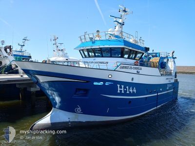
JANNETJE CORNELIS
Fishing
Current Trip
FISHINGGROUND
| Time Travelled | 22 h, 28 mins |
|---|---|
| Remaining Time | --- |
| Distance Travelled | 159.62 nm |
| Remaining Distance | --- |
| AVG Speed | 9.1 Noeuds |
| MAX Speed | 13.5 Noeuds |
| AVG Wind | 8.1 knots |
| MAX Wind | 11 knots |
| MIN Temp | 11.2°C / 52.16°F |
| MAX Temp | 12.6°C / 54.68°F |
| Tirant d eau | 5.5 m |
| Position reçue | 33 m depuis |
Current Position
| Longitude | 0.75841° |
|---|---|
| Latitude | 50.79541° |
| Etat | Engaged in Fishing |
| Vitesse | 10.1 Noeuds |
| Parcours | 240° |
| Zone | English Channel |
| Station | T-AIS |
| Position reçue | 33 m depuis |
Info
Information
The current position of JANNETJE CORNELIS is in English Channel with coordinates 50.79541° / 0.75841° as reported on 2024-05-07 00:17 by AIS to our vessel tracker app. The vessel's current speed is 10.1 Noeuds
The vessel JANNETJE CORNELIS (IMO: 9847255, MMSI: 232018240) is a Fishing It's sailing under the flag of [GB] United Kingdom.
In this page you can find informations about the vessels current position, last detected port calls, and current voyage information. If the vessels is not in coverage by AIS you will find the latest position.
The current position of JANNETJE CORNELIS is detected by our AIS receivers and we are not responsible for the reliability of the data. The last position was recorded while the vessel was in Coverage by the Ais receivers of our vessel tracking app.
The current draught of JANNETJE CORNELIS as reported by AIS is 5.5 meters
Weather
| Temperature | 11.9°C / 53.42°F |
|---|---|
| Wind Speed | 3 knots |
| Direction | 67° ENE |
| Pressure | 1013.3 hPa |
| Humidity | 84.1 % |
| Cloud Coverage | 37 % |
Featured Company
Last Port Calls
| Port | Arrival | Departure | Time In Port |
|---|---|---|---|
| 2024-05-03 00:17 | 2024-05-06 02:22 | 3 d | |
| 2024-04-25 20:25 | 2024-04-29 00:24 | 3 d | |
| 2024-04-19 04:39 | 2024-04-22 00:29 | 2 d | |
| 2024-04-18 00:07 | 2024-04-18 01:17 | 1 h | |
| 2024-04-11 18:10 | 2024-04-15 00:34 | 3 d | |
| 2024-04-04 23:54 | 2024-04-08 00:29 | 3 d | |
| 2024-03-28 21:38 | 2024-04-01 19:00 | 3 d | |
| 2024-03-28 10:42 | 2024-03-28 10:43 | 1 m | |
| 2024-03-21 22:40 | 2024-03-25 12:23 | 3 d | |
| 2024-03-14 20:37 | 2024-03-18 01:36 | 3 d |
Most Visited Ports (Last year)
| Port | Arrivals | |
|---|---|---|
| 44 | ||
| 13 | ||
| 8 | ||
| 1 | ||
| 1 | ||
| 1 |
Last Trips
| Origin | Departure | Destination | Arrival | Distance | |
|---|---|---|---|---|---|
| 2024-04-29 02:24 | 2024-05-03 02:17 | 393.15 nm | |||
| 2024-04-22 02:29 | 2024-04-25 22:25 | 478.20 nm | |||
| 2024-04-18 03:17 | 2024-04-19 06:39 | 182.73 nm | |||
| 2024-04-15 02:34 | 2024-04-18 02:07 | 371.48 nm | |||
| 2024-04-08 02:29 | 2024-04-11 20:10 | 416.61 nm | |||
| 2024-04-01 21:00 | 2024-04-05 01:54 | 344.37 nm | |||
| 2024-03-28 10:43 | 2024-03-28 22:38 | 96.60 nm | |||
| 2024-03-25 13:23 | 2024-03-28 10:42 | 295.49 nm | |||
| 2024-03-18 02:36 | 2024-03-21 23:40 | 200.24 nm | |||
| 2024-03-11 02:33 | 2024-03-14 21:37 | 520.15 nm |
Events
| Heure | Evenement | Détails | Position/ Destination | Info |
|---|---|---|---|---|
| 2024-05-06 23:31 | Detecté en mer | United Kingdom part of the English Channel |
50.85026 / .93096
English Channel
|
Vitesse: 9.1 kn Parcours: 242° |
| 2024-05-06 23:31 | Dans la zone couverte |
50.85026 / .93096
English Channel
|
Vitesse: 9.1 kn Parcours: 242° |
|
| 2024-05-06 20:37 | Hors de la zone couverte |
51.09001 / 1.47104
North Sea
|
Vitesse: 11 kn Parcours: 230° |
|
| 2024-05-06 19:51 | Démarrage | 12.52 nm, South East of RAMSGATE |
51.17853 / 1.65631
FISHINGGROUND
|
Vitesse: 4.5 kn Parcours: 219° |
| 2024-05-06 18:54 | Arret | 12.32 nm, South East of RAMSGATE |
51.20237 / 1.68250
FISHINGGROUND
|
Vitesse: 0.3 kn Parcours: 234° |
| 2024-05-06 17:50 | Démarrage | 11.43 nm, East of RAMSGATE |
51.28970 / 1.71920
FISHINGGROUND
|
Vitesse: 4.9 kn Parcours: 211° |
| 2024-05-06 16:55 | Arret | 11.63 nm, East of RAMSGATE |
51.31128 / 1.72924
FISHINGGROUND
|
Vitesse: 0.1 kn Parcours: 234° |
| 2024-05-06 16:16 | Démarrage | 12.13 nm, East of RAMSGATE |
51.32818 / 1.74359
FISHINGGROUND
|
Vitesse: 5 kn Parcours: 189° |
| 2024-05-06 15:22 | Arret | 12.33 nm, East of RAMSGATE |
51.34036 / 1.74810
FISHINGGROUND
|
Vitesse: 0.3 kn Parcours: 219° |
| 2024-05-06 14:11 | Démarrage | 14.59 nm, East of RAMSGATE |
51.39710 / 1.79213
FISHINGGROUND
|
Vitesse: 3.2 kn Parcours: 19° |