
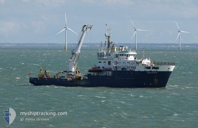
GALATEA
Buoy-laying Vessel
Current Trip
| Trip Time | 4 days |
|---|---|
| Trip Distance | 148.03 nm |
| AVG Speed | 8.5 Noeuds |
| MAX Speed | 13.9 Noeuds |
| Tirant d eau | 4.2 m |
| AVG Wind | 11.7 knots |
| MAX Wind | 32.3 knots |
| MIN Temp | 3.3°C / 37.94°F |
| MAX Temp | 13.2°C / 55.76°F |
| Position reçue | Maintenant |
Current Position
| Longitude | 1.28383° |
|---|---|
| Latitude | 51.94790° |
| Etat | Moored |
| Vitesse | |
| Parcours | 354° |
| Zone | North Sea |
| Station | T-AIS |
| Position reçue | Maintenant |
Info
Information
The current position of GALATEA is in North Sea with coordinates 51.94790° / 1.28383° as reported on 2024-05-04 11:08 by AIS to our vessel tracker app. The vessel's current speed is 0 Noeuds and is currently inside the port of HARWICH.
The vessel GALATEA (IMO: 9338591, MMSI: 235054097) is a Buoy-laying Vessel that was built in 2007 ( 17 Age ). It's sailing under the flag of [GB] United Kingdom.
In this page you can find informations about the vessels current position, last detected port calls, and current voyage information. If the vessels is not in coverage by AIS you will find the latest position.
The current position of GALATEA is detected by our AIS receivers and we are not responsible for the reliability of the data. The last position was recorded while the vessel was in Coverage by the Ais receivers of our vessel tracking app.
The current draught of GALATEA as reported by AIS is 4.2 meters
Weather
| Temperature | 12.7°C / 54.86°F |
|---|---|
| Wind Speed | 9 knots |
| Direction | 146° SE |
| Pressure | 1012.3 hPa |
| Humidity | 77.5 % |
| Cloud Coverage | 87 % |
Featured Company
Last Trips
| Origin | Departure | Destination | Arrival | Distance | |
|---|---|---|---|---|---|
| 2024-04-25 11:48 | 2024-04-29 15:00 | 148.03 nm | |||
| 2024-04-04 09:06 | 2024-04-21 10:47 | 543.20 nm | |||
| 2024-03-29 13:26 | 2024-04-01 12:50 | 238.67 nm | |||
| 2024-03-14 11:37 | 2024-03-27 12:18 | 373.50 nm | |||
| 2024-02-23 17:53 | 2024-03-10 23:30 | 708.17 nm |
Events
| Heure | Evenement | Détails | Position/ Destination | Info |
|---|---|---|---|---|
| 2024-05-01 00:04 | Changement d'ETA | 2025/04/29 15:00 2024/04/29 15:00 |
51.94790 / 1.28381
[GB] HARWICH
|
Vitesse: Parcours: 353° |
| 2024-04-29 14:29 | Etat Changé | Moored Under way using engine |
51.94790 / 1.28381
[GB] HARWICH
|
Vitesse: Parcours: 354° |
| 2024-04-29 14:00 | Port d'arrivée |
|
51.94886 / 1.28355
[GB] HARWICH
|
Vitesse: 1.2 kn Parcours: 1° |
| 2024-04-29 13:49 | Arret | 0.56 nm, South West of FELIXSTOWE |
51.95276 / 1.28838
TRINITY PIER HARWICH
|
Vitesse: 0.3 kn Parcours: 287° |
| 2024-04-29 10:51 | Etat Changé | Under way using engine Restricted manoeuverability |
51.70715 / 1.44673
TRINITY PIER HARWICH
|
Vitesse: 6.4 kn Parcours: 94.3° |
| 2024-04-29 10:51 | Démarrage | 10.43 nm, South East of F HALLS COMPANY BOAT |
51.70715 / 1.44673
TRINITY PIER HARWICH
|
Vitesse: 7.4 kn Parcours: 94.5° |
| 2024-04-29 10:49 | Changement de destination | TRINITY PIER HARWICH BLACK DEEP NO.3 LB |
51.70692 / 1.44306
TRINITY PIER HARWICH
|
Vitesse: 0.7 kn Parcours: 52° |
| 2024-04-29 10:49 | Changement d'ETA | 2024/04/29 15:00 2024/04/29 11:00 |
51.70692 / 1.44306
TRINITY PIER HARWICH
|
Vitesse: 0.7 kn Parcours: 52° |
| 2024-04-29 09:58 | Changement de destination | BLACK DEEP NO.3 LB BLACK DEEP NO.4 LB |
51.70652 / 1.44461
BLACK DEEP NO.3 LB
|
Vitesse: Parcours: 28° |
| 2024-04-29 09:58 | Changement d'ETA | 2024/04/29 11:00 2024/04/29 09:30 |
51.70652 / 1.44461
BLACK DEEP NO.3 LB
|
Vitesse: Parcours: 28° |