
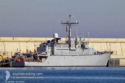
FRENCH WARSHIP
Not available
Current Trip
A
| Time Travelled | 40 days |
|---|---|
| Remaining Time | --- |
| Distance Travelled | 779.03 nm |
| Remaining Distance | --- |
| AVG Speed | 7.4 Noeuds |
| MAX Speed | 11 Noeuds |
| AVG Wind | 12.5 knots |
| MAX Wind | 18 knots |
| MIN Temp | 19.7°C / 67.46°F |
| MAX Temp | 31.7°C / 89.06°F |
| Tirant d eau | 0 m |
| Position reçue | 6 d depuis |
Current Position
| Longitude | 39.15709° |
|---|---|
| Latitude | 21.47079° |
| Etat | Under way using engine |
| Vitesse | 4.7 Noeuds |
| Parcours | 36.1° |
| Zone | Red Sea |
| Station | T-AIS |
| Position reçue | 6 d depuis |
Info
Information
The current position of FRENCH WARSHIP is in Red Sea with coordinates 21.47079° / 39.15709° as reported on 2024-05-03 10:40 by AIS to our vessel tracker app. The vessel's current speed is 4.7 Noeuds
The vessel FRENCH WARSHIP (MMSI: 228773000) is a Not available It's sailing under the flag of [FR] France.
In this page you can find informations about the vessels current position, last detected port calls, and current voyage information. If the vessels is not in coverage by AIS you will find the latest position.
The current position of FRENCH WARSHIP is detected by our AIS receivers and we are not responsible for the reliability of the data. The last position was recorded while the vessel was in Coverage by the Ais receivers of our vessel tracking app.
Weather
| Temperature | 31.8°C / 89.24°F |
|---|---|
| Wind Speed | 14 knots |
| Direction | 293° WNW |
| Pressure | 1008 hPa |
| Humidity | 35.6 % |
| Cloud Coverage | --- |
Featured Company
Last Port Calls
| Port | Arrival | Departure | Time In Port |
|---|---|---|---|
| 2024-04-02 07:05 | 2024-04-02 17:19 | 10 h | |
| 2024-03-27 19:30 | 2024-03-30 10:01 | 2 d | |
| 2024-03-24 06:35 | 2024-03-27 18:01 | 3 d | |
| 2024-03-19 17:11 |
Most Visited Ports (Last year)
| Port | Arrivals | |
|---|---|---|
| 5 | ||
| 2 | ||
| 1 | ||
| 1 |
Events
| Heure | Evenement | Détails | Position/ Destination | Info |
|---|---|---|---|---|
| 2024-05-03 10:40 | Hors de la zone couverte |
21.47079 / 39.15709
Red Sea
|
Vitesse: 4.7 kn Parcours: 36.1° |
|
| 2024-05-03 07:19 | Dans la zone couverte |
21.48782 / 39.06671
Red Sea
|
Vitesse: 5.5 kn Parcours: 108.1° |
|
| 2024-05-03 05:14 | Hors de la zone couverte |
21.48582 / 39.07256
Red Sea
|
Vitesse: 0.7 kn Parcours: 201.4° |
|
| 2024-05-03 00:40 | Dans la zone couverte |
21.52167 / 38.92000
Red Sea
|
Vitesse: 2 kn Parcours: 185° |
|
| 2024-05-02 22:50 | Hors de la zone couverte |
21.47355 / 38.93212
Red Sea
|
Vitesse: 2.7 kn Parcours: 173° |
|
| 2024-05-02 21:49 | Dans la zone couverte |
21.49229 / 38.93469
Red Sea
|
Vitesse: 2.3 kn Parcours: 350.4° |
|
| 2024-05-02 18:55 | Hors de la zone couverte |
21.44592 / 38.94378
Red Sea
|
Vitesse: 1.8 kn Parcours: 284.8° |
|
| 2024-05-02 16:07 | Démarrage | 8.26 nm, West of JEDDAH |
21.48508 / 39.00188
A
|
Vitesse: 4.8 kn Parcours: 140.4° |
| 2024-05-02 15:08 | Dans la zone couverte |
21.49508 / 38.98597
Red Sea
|
Vitesse: 0.3 kn Parcours: 56.7° |
|
| 2024-05-02 13:50 | Hors de la zone couverte |
21.47184 / 39.00902
Red Sea
|
Vitesse: 1.5 kn Parcours: 313.7° |